Pages
-

-
Title
-
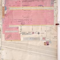
Sanborn Map, Kansas City, Vol. 5, 1909-1938, Page p603
-
Description
-
A portion of Kansas City from E. Front Street south to E. 1st Street and from N. Vine Street east to Woodland Avenue, showing buildings, streets, railroads, and additions. Large numbers at edges of page refer to page with adjoining area.
-
Date
-
1909/1938
-
Object Type
-
Map
-

-
Title
-
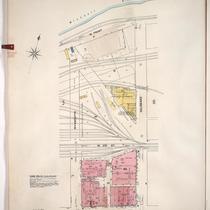
Sanborn Map, Kansas City, Vol. 5, 1909-1938, Page p605
-
Description
-
A portion of Kansas City from E. Front Street south to Guinotte Avenue and from N. Garfield Avenue east to N. Park Avenue, showing buildings, streets, and additions. Large numbers at edges of page refer to page with adjoining area.
-
Date
-
1909/1938
-
Object Type
-
Map
-
-
Title
-
Sanborn Map, Kansas City, Vol. 5, 1909-1938, Page p724
-
Description
-
A portion of Kansas City in the Leed's Industrial District, showing buildings, streets, and railroads. Large numbers at edges of page refer to page with adjoining area. At the top of page, "Add'l Sheet, Nov. 1928."
-
Date
-
1909/1938
-
Object Type
-
Map
-

-
Title
-
Sanborn Map, Kansas City, Vol. 5, 1909-1938, Page p604
-
Description
-
A portion of Kansas City from E. Front Street south to E. 1st Street and from N. Woodland Avenue east to Garfield Avenue, showing buildings, streets, railroads, and additions. Shows The Kansas City Star printing paper storage house. Large numbers at edges of page refer to page with adjoining area.
-
Date
-
1909/1938
-
Object Type
-
Map
-

-
Title
-
Sanborn Map, Kansas City, Vol. 5, 1909-1938, Page p689
-
Description
-
A portion of Kansas City at the intersection of Cambridge Avenue and Winner Road, showing buildings, streets, railroads, and additions. Large numbers at edges of page refer to page with adjoining area. At the top of page, "New Sheet May 1922."
-
Date
-
1909/1938
-
Object Type
-
Map
-

-
Title
-
Sanborn Map, Kansas City, Vol. 5, 1909-1938, Page p706
-
Description
-
A portion of Kansas City from E. 38th Street south to E. 40th Street and from Fremont Avenue east to Bennington Avenue, showing buildings, streets, railroads, and additions. Large numbers at edges of page refer to page with adjoining area.
-
Date
-
1909/1938
-
Object Type
-
Map
-

-
Title
-
Sanborn Map, Kansas City, Vol. 5, 1909-1938, Page p690
-
Description
-
A portion of Kansas City in the Sheffield neighborhood near Crystal Avenue and the Blue River, showing buildings, streets, railroads, and additions. Large numbers at edges of page refer to page with adjoining area.
-
Date
-
1909/1938
-
Object Type
-
Map
-

-
Title
-
Sanborn Map, Kansas City, Vol. 1, 1909-1938, Page p028
-
Description
-
A portion of Kansas City from W. 9th Street south to W. 11th Street and from Mulberry east to Santa Fe, showing buildings, streets, railroads, and additions. Large numbers at edges of page refer to page with adjoining area.
-
Date
-
1909/1938
-
Object Type
-
Map
-

-
Title
-
Sanborn Map, Kansas City, Vol. 5, 1909-1938, Page p692
-
Description
-
A portion of Kansas City from Washington Park Boulevard south to E. 7th Street and from Cambridge Avenue east to Winchester Avenue, showing buildings, streets, and additions. Large numbers at edges of page refer to page with adjoining area.
-
Date
-
1909/1938
-
Object Type
-
Map
-

-
Title
-
Sanborn Map, Kansas City, Vol. 5, 1909-1938, Page p608
-
Description
-
A portion of Kansas City from Rochester Avenue south to Guinotte Avenue and from N. Montgall Avenue east to Guinotte Avenue, showing buildings, streets, railroads, and additions. Large numbers at edges of page refer to page with adjoining area.
-
Date
-
1909/1938
-
Object Type
-
Map
-

-
Title
-
Sanborn Map, Kansas City, Vol. 5, 1909-1938, Page p607
-
Description
-
A portion of Kansas City from Rochester Avenue south to Guinotte Avenue and from N. Wabash Avenue east to N. Montgall Avenue, showing buildings, streets, railroads, and additions. Large numbers at edges of page refer to page with adjoining area.
-
Date
-
1909/1938
-
Object Type
-
Map
-

-
Title
-
Sanborn Map, Kansas City, Vol. 1, 1909-1938, Page p006
-
Description
-
A portion of Kansas City from W. Front Street south to W. 3rd Street and from Delaware east to Main Street, showing buildings, streets, and additions. Large numbers at edges of page refer to page with adjoining area.
-
Date
-
1909/1938
-
Object Type
-
Map
-
-
Title
-
Sanborn Map, Kansas City, Vol. 1, 1909-1938, Page p005
-
Description
-
A portion of Kansas City from W. Front Street south to W. 3rd Street and from Wyandotte east to Delaware, showing buildings, streets, and additions. Large numbers at edges of page refer to page with adjoining area.
-
Date
-
1909/1938
-
Object Type
-
Map
-

-
Title
-
Sanborn Map, Kansas City, Vol. 5, 1909-1938, Page p707
-
Description
-
A portion of Kansas City at the intersection of E. 39th Street and Ewing Avenue, showing buildings, streets, railroads, and additions. Large numbers at edges of page refer to page with adjoining area.
-
Date
-
1909/1938
-
Object Type
-
Map
-

-
Title
-
Sanborn Map, Kansas City, Vol. 5, 1909-1938, Page p699
-
Description
-
A portion of Kansas City from E. 16th Street south to E. 17th Street and from Ewing Avenue east to Bristol Avenue, showing buildings, streets, railroads, and additions. Large numbers at edges of page refer to page with adjoining area.
-
Date
-
1909/1938
-
Object Type
-
Map
-

-
Title
-
Sanborn Map, Kansas City, Vol. 5, 1909-1938, Page p722
-
Description
-
A portion of Kansas City in the Sheffield Industrial District, showing buildings, streets, and railroads. Large numbers at edges of page refer to page with adjoining area. At the top of page, "New Sheet, May 1922."
-
Date
-
1909/1938
-
Object Type
-
Map
-

-
Title
-
Sanborn Map, Kansas City, Vol. 5, 1909-1938, Page p606
-
Description
-
A portion of Kansas City from Rochester Avenue south to Guinotte Avenue and from N. Park Avenue east to N. Wabash Avenue, showing buildings, streets, railroads, and additions. Large numbers at edges of page refer to page with adjoining area.
-
Date
-
1909/1938
-
Object Type
-
Map
-

-
Title
-
Sanborn Map, Kansas City, Vol. 5, 1909-1938, Page p614
-
Description
-
A portion of Kansas City at the intersection of N. Monroe Avenue and Nicholson Avenue, showing the W. S. Dickey Clay Manufacturing Company and Missouri Pacific Railroad roundhouse. Large numbers at edges of page refer to page with adjoining area.
-
Date
-
1909/1938
-
Object Type
-
Map
-

-
Title
-
Sanborn Map, Kansas City, Vol. 5, 1909-1938, Page p702
-
Description
-
A portion of Kansas City from E. 16th Street south to E. 17th Street and from Eastern Avenue east to Palmer Avenue, showing buildings, streets, railroads, and additions. Large numbers at edges of page refer to page with adjoining area.
-
Date
-
1909/1938
-
Object Type
-
Map
-

-
Title
-
Sanborn Map, Kansas City, Vol. 5, 1909-1938, Page p609
-
Description
-
A portion of Kansas City from E. Front Street south to Heim Avenue and from N. Brooklyn Avenue east to N. Olive, showing buildings, streets, railroads, and additions. Large numbers at edges of page refer to page with adjoining area.
-
Date
-
1909/1938
-
Object Type
-
Map
Pages
