-

-
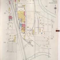
Title
-
Sanborn Map, Kansas City, Vol. 5, 1940-1941, Page p1216
-
Description
-
A portion of Kansas City from the Big Blue River south to E. 24th Street and from the Saint Louis and San Francisco Railroad east to Tullis Avenue, showing buildings and streets. Large numbers at edges of page refer to page with adjoining area. Indicated at top of sheet that this page number corresponds with pages 707, 710 and 722 in Vol. 5, 1909-1938.
-
Date
-
1940/1941
-
Object Type
-
Map
-

-
Title
-
Sanborn Map, Kansas City, Vol. 5, 1940-1941, Page p0645
-
Description
-
A portion of Kansas City just north of the intersection of Bristol Avenue and E. 6th Street, showing buildings, railroads and streets. Large numbers at edges of page refer to page with adjoining area. Indicated at top of sheet that this page number corresponds with pages 689, 690, and 692 in Vol. 5, 1909-1938.
-
Date
-
1940/1941
-
Object Type
-
Map
-
-
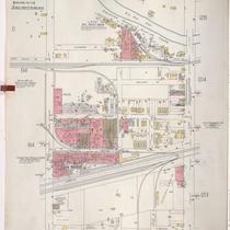
Title
-
Sanborn Map, Kansas City, Vol. 5, 1940-1941, Page p1214
-
Description
-
A portion of Kansas City from E. 15th Street south to E. 18th Street and from Crystal Avenue east to Winchester Avenue, showing buildings and streets. Large numbers at edges of page refer to page with adjoining area. Indicated at top of sheet that this page number corresponds with pages 698 and 700-702 in Vol. 5, 1909-1938.
-
Date
-
1940/1941
-
Object Type
-
Map
-

-
Title
-
Sanborn Map, Kansas City, Vol. 5, 1940-1941, Page p0644
-
Description
-
A portion of Kansas City from St. John Avenue south to Wilson Avenue and from Bennington Avenue east to Cambridge Avenue, showing buildings, railroads, and streets. Large numbers at edges of page refer to page with adjoining area. Indicated at top of sheet that this page number corresponds with pages 603, 613, 687, 689, 695 and 711 in Vol. 5, 1909-1938.
-
Date
-
1940/1941
-
Object Type
-
Map
-
-
Title
-
Sanborn Map, Kansas City, Vol. 5, 1940-1941, Page p0607
-
Description
-
A portion of Kansas City from E. 12th Street south to E. 15th Street and from Bristol Avenue east to Manchester Avenue, showing buildings, streets, and railroad lines. Large numbers at edges of page refer to page with adjoining area. Indicated at top of sheet that this page number corresponds with pages 696, 698, 701, and 710 in Vol. 5, 1909-1938.
-
Date
-
1940/1941
-
Object Type
-
Map
-

-
Title
-
Sanborn Map, Kansas City, Vol. 5, 1940-1941, Page p0614
-
Description
-
A portion of Kansas City from E. 6th Street south to E. 12th Street and from Winchester Avenue east to Eastern Avenue, showing buildings, railroads, and streets. Large numbers at edges of page refer to page with adjoining area. Indicated at top of sheet that this page number corresponds with pages 696, 699, 703, and 709 in Vol. 5, 1909-1938.
-
Date
-
1940/1941
-
Object Type
-
Map
-

-
Title
-
Sanborn Map, Kansas City, Vol. 5, 1940-1941, Page p0635
-
Description
-
A portion of Kansas City from Gladstone Boulevard south to Norledge Avenue and from Elmwood Avenue east to N. Quincy Avenue, showing buildings, railroads, and streets. Large numbers at edges of page refer to page with adjoining area. Indicated at top of sheet that this page number corresponds with page 613 and 615 in Vol. 5, 1909-1938.
-
Date
-
1940/1941
-
Object Type
-
Map
