-

-
Title
-
Kansas City Illustrated, 1902
-
Description
-
Intricate illustration of the cemetery's main building on a bluff with list of the cemetery's organizers and plans.
-
Date
-
1902
-
Object Type
-
Book
-

-
Title
-
A Friend of ''Jim'' Bridger
-
Description
-
Article describes a man's encounter with legendary explorer Jim Bridger in the Spring of 1850. William Walker, of Scandia, Kansas, was welcomed by Bridger in a small Indian village in Utah while travelling West to California.
-
Date
-
2005-11-21
-
Object Type
-
Newspaper Article
-
-
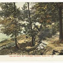
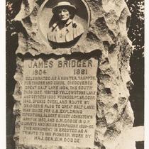
Title
-
Jim Bridger Monument
-
Description
-
Postcard of the Jim Bridger Monument in Mount Washington Cemetery.
-
Object Type
-
Postcard
-
-
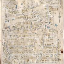
Title
-
Sanborn Map, Kansas City, Vol. 6, 1917-1957, Page p836
-
Description
-
A portion of the Intercity District connecting Kansas City, Missouri, and Independence, Missouri, from Morrell Avenue south to Independence Avenue and from Blue Ridge Boulevard east to Tennessee Avenue, showing buildings, streets, and additions. Large numbers at edges of page refer to page with adjoining area.
-
Date
-
1917/1957
-
Object Type
-
Map
-

-
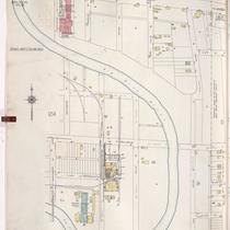
Title
-
Sanborn Map, Kansas City, Vol. 6, 1917-1957, Page p833
-
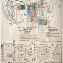
Description
-
Index to New Report of Intercity District showing area connecting Kansas City, Missouri, and Independence, Missouri, as well as Sugar Creek district, dated December 1932. At bottom of sheet is a portion of Sugar Creek from Scarritt Avenue south to Kentucky Avenue and from Home Avenue east to Ralston Avenue, showing buildings, streets, and additions. Large numbers at edges of page refer to page with adjoining area. A new report for Sugar Creek is also attached dated November 1939.
-
Date
-
1917/1957
-
Object Type
-
Map
-

-
Title
-
Sanborn Map, Kansas City, Vol. 6, 1917-1957, Page p839
-
Description
-
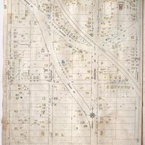
A portion of Kansas City from Independence Avenue south to about E. 10th Street and from Brookside Drive east to Overton Avenue, showing buildings, streets, and additions. Large numbers at edges of page refer to page with adjoining area.
-
Date
-
1917/1957
-
Object Type
-
Map
-
-
Title
-
Sanborn Map, Kansas City, Vol. 5, 1940-1941, Page p1215
-
Description
-
A portion of Kansas City from E. 15th Street south to E. 19th Street and from Manchester Avenue east to Ashland Avenue, showing buildings and streets. Large numbers at edges of page refer to page with adjoining area. Indicated at top of sheet that this page number corresponds with pages 652, 707 and 710 in Vol. 5, 1909-1938.
-
Date
-
1940/1941
-
Object Type
-
Map
-
-
Title
-
Sanborn Map, Kansas City, Vol. 6, 1917-1945, Page p839
-
Description
-
A portion of the Intercity District connecting Kansas City, Missouri, and Independence, Missouri, from Independence Avenue south to E. 9th Street and from Brookside Drive east to Overton Avenue, showing buildings, streets, and additions. Large numbers at edges of page refer to page with adjoining area.
-
Date
-
1917/1945
-
Object Type
-
Map
-
-
Title
-
Sanborn Map, Kansas City, Vol. 6, 1917-1945, Page p833
-
Description
-
Index to New Report of Intercity District showing area connecting Kansas City, Missouri and Independence, Missouri, as well as Sugar Creek district, dated December 1932. At bottom of sheet is a portion of Sugar Creek from Scarritt Avenue south to Kentucky Avenue and from Home Avenue east to Ralston Avenue, showing buildings, streets and additions. Large numbers at edges of page refer to page with adjoining area.
-
Date
-
1917/1945
-
Object Type
-
Map
-

-
Title
-
Mount Washington Cemetery
-
Description
-
Physical description of Mount Washington Cemetery, at the time "lying east of the city about a half-hour's ride and reached from any portion of it by a five-cent car fare." Includes a photograph.
-
Date
-
1903-04
-
Object Type
-
Magazine Article