-
-
Title
-
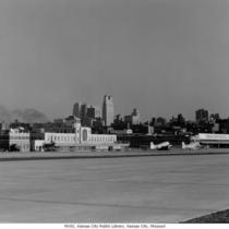
Municipal Airport
-
Description
-
View of the terminal building at Municipal Airport, looking toward the southeast with the Kansas City skyline in the background. There are TWA airplanes on the ground and the Transcontinental & Western Air, Inc. (TWA) airport hanger building is in view.
-
Date
-
1939
-
Object Type
-
Photograph
-

-
Title
-
Aerial View of Downtown Kansas City
-
Description
-
Aerial view looking northwest from about 16th Street, from Quality Hill to Locust Street. The Missouri River and Municipal Airport are visible as well as the Broadway Bridge, 2nd Hannibal Bridge, and the Paseo Bridge.
-
Date
-
1962-11-21
-
Object Type
-
Photograph
-

-
Title
-
Aerial View of Downtown Kansas City
-
Description
-
Aerial view of downtown Kansas City and portions of North Kansas City, Missouri, looking toward the northwest. The Municipal Airport is in view as well as the Missouri River as it bends to the north. The Broadway Bridge, 2nd Hannibal Bridge, and the ASB Bridge, in that order from left to right, can be seen spanning the river. No print image; negative and digital only.
-
Date
-
1962-11-20
-
Object Type
-
Negative
-
-
Title
-
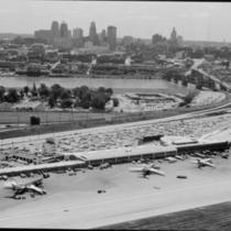
Municipal Airport and Downtown Skyline
-
Description
-
Aerial view looking south to downtown Kansas City showing Municipal Airport terminal buildings and parking lot. Airplanes sit on the taxiway. The Broadway Bridge spans the Missouri River on the right. The Harlem neighborhood north of the Missouri River can also be seen. Airport was later renamed Charles B. Wheeler Downtown Airport.
-
Date
-
1960~
-
Object Type
-
Negative
-

-
Title
-
Municipal Airport
-
Description
-
Low, aerial view of Municipal Airport, looking toward the south with the Kansas City, Missouri skyline in view. A portion of the runway and the airport terminal building are visible as well as various airplanes on the ground. The Broadway Bridge, 2nd Hannibal Bridge and ASB Bridge can be seen crossing the Missouri River.
-
Date
-
1970~
-
Object Type
-
Photograph
-

-
Title
-
Aerial View of Downtown Kansas City
-
Description
-
Aerial view of downtown Kansas City and portions of North Kansas City, Missouri, looking toward the northwest. The Municipal Airport is in view as well as the Missouri River as it bends to the north. The Fairfax Airport is on the west side of the river. The Broadway Bridge, 2nd Hannibal Bridge, and the ASB Bridge, in that order from left to right, can be seen spanning the river. The Fairfax Bridge can be seen in the distance beyond the airport.
-
Date
-
1960~
-
Object Type
-
Photograph
-

-
Title
-
Aerial View of Downtown Kansas City
-
Description
-
Aerial view of downtown Kansas City and portions of North Kansas City, Missouri, looking toward the northwest. The Municipal Airport is in view as well as the Missouri River as it bends to the north The Broadway Bridge, 2nd Hannibal Bridge, and the ASB Bridge, in that order from left to right, can be seen spanning the river. The Fairfax Bridge can be seen in the distance beyond the airport.
-
Date
-
1960-12
-
Object Type
-
Photograph

