-

-
Title
-
The Kansas City Times' Map of Oklahoma
-
Description
-
"Taken from government surveys." Shows proposed railroad and stage line and includes "Direction for Locating a Claim." Specific areas of Indian tribes noted.
-
Date
-
1888
-
Object Type
-
Map
-
-
Title
-
Correct Map of Oklahoma and Indian Territories
-
Description
-
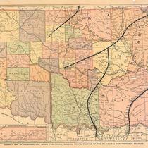
Map of Oklahoma Territory and Indian Territory. Railroad lines, counties, and Indian jurisdictions (Osage, Kiowa, Comanche, and Apache) are shown. The following Indian nations are shown in Indian Territory: Cherokee, Choctaw, Chickasaw, Seminole, Creek.
-
Date
-
1901~
-
Object Type
-
Map
-

-
Title
-
Map of the Cherokee Strip Indian Territory
-
Description
-
Map shows trails, ranches, corrals and branding pens, camps, springs, etc. of the Cherokee Strip Indian Territory leased by the Cherokee Strip Live Stock Association. Compiled from surveys of ranges made for the Association.
-
Date
-
1884
-
Object Type
-
Map
-

-
Title
-
Historical Map of Oklahoma
-
Description
-
Pictorial map of Oklahoma showing various geographical and historical points of interest. Summary of Oklahoma-area history from 1226 B. C. inset.
-
Date
-
1931
-
Object Type
-
Map
-
-
Title
-
Oklahoma Indian and Cowboy Views, Photograph 01
-
Description
-
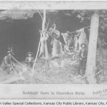
Photograph one of twenty-four in Collection of Oklahoma Indian and Cowboy Views [ca. 1889] by William S. Prettyman and George B. Cornish. It is titled "Robbers Cave in Cherokee Strip" and shows three men in front of the Barker Outlaw Cave. From left to right, the Reverend A.C. Kronk, Arkansas City; J.W. "Cherokee" Jordan; and photographer William S. Prettyman.
-
Date
-
1885~
-
Object Type
-
Photograph
