-

-
Title
-
Osceola, Land of Osage River Lore
-
Description
-
Description of the early history of the Missouri territory of the Osage Indians, especially in Saint Clair and Jackson Counties from 1719 to 1825.
-
Date
-
1960-07
-
Object Type
-
Magazine Article
-
-
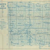
Title
-
Bates CO. Missouri
-
Description
-
Map of Bates County, Missouri, that includes paved roads, graveled roads, state or county roads not highly improved, roads, interstates and highways, railroads, drainage district line, municipal township lines, streams, and schools. Includes the townships of West Boone, East Boone, Deer Creek, Grand River, Mingo, West Point, Elkhart, Mound, Shawnee, Spruce, Homer, Charlotte, Mount Pleasant, Summit, Deepwater, Walnut, New Home, Lone Oak, Pleasant Gap, Hudson, Howard, Osage, Prairie, and Rockville.
-
Object Type
-
Map
-

-
Title
-
The Contributors' Club: Old Times on the Missouri
-
Description
-
Article about the history of navigation on the Missouri River and Osage River, giving comparisons of different times, as far back as the Missouri Indians, to an 1886 voyage aboard the steamboat "General Meade."
-
Date
-
1903-09
-
Object Type
-
Magazine Article
-

-
Title
-
Site of the Old Toll Bridge at Linn Creek
-
Description
-
Photo and text about the old toll bridge over the Osage River at Linn Creek, now submerged beneath the Lake of the Ozarks.
-
Date
-
1932-06
-
Object Type
-
Magazine Article
-

-
Title
-
One Hundred Years on the Missouri River
-
Description
-
Article about the history of steamboats on the Missouri and Osage Rivers, especially the early ones visiting Saint Louis and Kansas City, including the following: "Western Engineer" (page 21), "Zebulon M. Pike" and "Maid of Orleans" (page 23), "Steamboat Trapper" (page 24), "Flora Jones" (page 31), "James H. Lucas," "Wyoming," "Ben W. Lewis," "Morning Star," "Meteor," "Timour," "Saluda," and "Edna" (page 33), "Twilight" (page 34), "Bertrand," "Butte," "Boreas," "Ozark Uplift," and "Missouri Belle" (page 36).
-
Date
-
1921-10-03
-
Object Type
-
Magazine Article
-

-
Title
-
Map of Vernon Co. Mo.
-
Description
-
Civil War era map of Vernon County, Missouri showing roads, rivers and towns. Includes a chart for typical section numbering pattern and shows state and county lines. No map key is included.
-
Object Type
-
Map
-

-
Title
-
Green Bay Terrace Quadrangle
-
Description
-
Topographical map of the Lake of the Ozarks within Camden County, Missouri, including the Niangua and Little Niangua Arms of the lake, as well as the Osage River. Also shown are churches and schools, as well as ridges, bluffs, hollows, and other geographical features of the area.
-
Date
-
1934
-
Object Type
-
Map
-

-
Title
-
Versailles Sheet
-
Description
-
Topographical map of areas of Morgan, Camden, and Miller counties in Missouri, including segments of the Osage and Niangua rivers and the towns of Bagnell and Versailles. Map depicts railroads and a local iron works.
-
Date
-
1893
-
Object Type
-
Map
-

-
Title
-
Bagnell Quadrangle
-
Description
-
Topographical map of part of Miller County, Missouri, an area northeast of the Lake of the Ozarks. Map includes Osage River and Little Gravois Creek, as well as depicting tranmission lines, peaks, schools, and churches.
-
Date
-
1934
-
Object Type
-
Map
-

-
Title
-
Warsaw Sheet
-
Description
-
Topographical map of areas of Benton and Hickory counties in Missouri, including segments of the Osage and Pomme de Terre rivers and the town of Warsaw. Map also depicts other communities, railroads, and some local roads.
-
Date
-
1894
-
Object Type
-
Map
-

-
Title
-
Louis Vasquez, Mountain Man
-
Description
-
Mention of "the old Harmony Mission on the Osage River," visited by mountain man Old Bill Williams in the mid-1800s, on a trading assignment from Fort Osage.
-
Date
-
1958-12-01
-
Object Type
-
Magazine Article
-

-
Title
-
Lincoln SE Quadrangle
-
Description
-
Topographical map of Benton County, Missouri, including sections of the Osage River and the Lake of the Ozarks. Also depicted are fish hatcheries, churches, schools, cemeteries, and roads of varying grades.
-
Date
-
1959
-
Object Type
-
Map
-

-
Title
-
Green Bay Terrace Quadrangle
-
Description
-
Topographical map of the Lake of the Ozarks within Camden County, Missouri, including the Niangua and Little Niangua Arms of the lake, as well as the Osage River. Also shown are churches and schools, as well as ridges, bluffs, hollows, and other geographical features of the area.
-
Date
-
1959
-
Object Type
-
Map
