Pages
-

-
Title
-
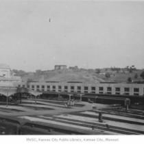
Railroad Tracks near Terminal Warehouse
-
Description
-
View along railroad tracks near the Midwest Terminal Warehouse Co., Number 3 building; shows portion of Kansas City skyline in the distance.
-
Date
-
1951
-
Object Type
-
Photograph
-

-
Title
-
Flood Damaged Railroad Yard
-
Description
-
Overhead view of men working to repair a railroad yard in the aftermath of the 1951 Flood.
-
Date
-
1951
-
Object Type
-
Photograph
-

-
Title
-
Flood Damaged Area
-
Description
-
View of damaged street and railroad tracks in the aftermath of the 1951 Flood; shows part of the Kansas City Pump Co. (far right) sign and building.
-
Date
-
1951
-
Object Type
-
Photograph
-
-
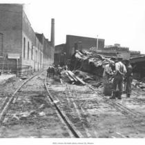
Title
-
Flood Damaged Area
-
Description
-
Unidentified men working on recovery effort after the 1951 Flood; shows damaged buildings and railroad tracks.
-
Date
-
1951
-
Object Type
-
Photograph
-

-
Title
-
Flood Damaged Area
-
Description
-
Overhead view of an area in the West Bottoms showing damage from the 19151 Flood; visible are railroad tracks and buildings owned by the Rudy-Patrick Seed Co., Crooks Terminal Warehouse Co., the Peppard Seed Co., Sewall Paint & Varnish Co., Helmers Manufacturing Co., and Standard Seed Co.
-
Date
-
1951
-
Object Type
-
Photograph
-
-
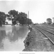
Title
-
Railroad Tracks near Flooded Area
-
Description
-
View of flooding near railroad tracks in an unidentified area, probably in the aftermath of the 1951 Flood.
-
Date
-
1951
-
Object Type
-
Photograph
-

-
Title
-
Swope Park
-
Description
-
View of tree lined road and a railway track. Identified on the back as: "Swope tract, 1915, Rev. F.M. Smith, Independence."
-
Date
-
1915
-
Object Type
-
Photograph
-
-
Title
-
Union Station
-
Description
-
Partial view of Union Station and the tracks located on the west side of the station. View is looking toward the southeast. In view is hill across the street from the station where the Liberty Memorial was later built. Some train cars can be seen on the tracks. Photograph taken from Broadway Viaduct.
-
Date
-
1915-08
-
Object Type
-
Photograph
-

-
Title
-
Liberty Bell in Kansas City
-
Description
-
View of an unidentified train track area, perhaps Union Station area, with the train carrying the Liberty Bell located on the last special flat car. Back of the photograph reads: "Famous Liberty Bell in Kansas City, W. Malcom Lowry."
-
Date
-
1915
-
Object Type
-
Photograph
-

-
Title
-
Union Station
-
Description
-
View of train tracks associated with Union Station. Train engines and railroad cars are in view.
-
Date
-
1928
-
Object Type
-
Photograph
-
-
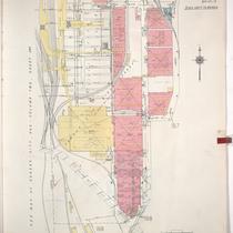
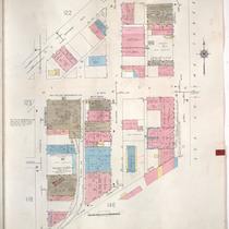
Title
-
Sanborn Map, Kansas City, Vol. 1A, 1939-1949, Page p170
-
Description
-
A portion of Kansas City from W. 17th Street south to about W. 23rd Street and from State Line east to Liberty, showing buildings and streets. Large numbers at edges of page refer to page with adjoining area.
-
Date
-
1939/1949
-
Object Type
-
Map
-

-
Title
-
Sanborn Map, Kansas City, Vol. 1A, 1939-1949, Page p169
-
Description
-
A portion of Kansas City from W. 12th Street south to W. 17th Street and from State Line east to Genessee, showing buildings, railroads, and streets. Large numbers at edges of page refer to page with adjoining area.
-
Date
-
1939/1949
-
Object Type
-
Map
-
-
Title
-
Sanborn Map, Kansas City, Vol. 1A, 1939-1949, Page p124
-
Description
-
A portion of Kansas City from W. 19th Street south to W. 22nd Street and from Wyandotte east to Main Street, showing buildings and streets. Large numbers at edges of page refer to page with adjoining area.
-
Date
-
1939/1949
-
Object Type
-
Map
-

-
Title
-
Sanborn Map, Kansas City, Vol. 1A, 1939-1949, Page p146
-
Description
-
A portion of Kansas City from W. 22nd Street south to W. 25th Street and from Broadway east to Main Street, showing buildings and streets. Large numbers at edges of page refer to page with adjoining area.
-
Date
-
1939/1949
-
Object Type
-
Map
-

-
Title
-
Sanborn Map, Kansas City, Vol. 5, 1940-1941, Page p0645
-
Description
-
A portion of Kansas City just north of the intersection of Bristol Avenue and E. 6th Street, showing buildings, railroads and streets. Large numbers at edges of page refer to page with adjoining area. Indicated at top of sheet that this page number corresponds with pages 689, 690, and 692 in Vol. 5, 1909-1938.
-
Date
-
1940/1941
-
Object Type
-
Map
-

-
Title
-
Sanborn Map, Kansas City, Vol. 5, 1940-1941, Page p0646
-
Description
-
A portion of Kansas City just north of the intersection of Wilson and Manchester Avenue, showing buildings, railroads, and streets. Large numbers at edges of page refer to page with adjoining area. Indicated at top of sheet that this page number corresponds with pages 703, 704, 711, and 723 in Vol. 5, 1909-1938.
-
Date
-
1940/1941
-
Object Type
-
Map
-

-
Title
-
Sanborn Map, Kansas City, Vol. 1A, 1939-1949, Page p172
-
Description
-
A portion of Kansas City from W. 16th Street south to W. 17th Street and from Genessee east to Liberty, showing buildings, railroads and streets. Large numbers at edges of page refer to page with adjoining area. Written in red in upper right corner, "Poor Section."
-
Date
-
1939/1949
-
Object Type
-
Map
-

-
Title
-
Sanborn Map, Kansas City, Vol. 5, 1940-1941, Page p0618
-
Description
-
A portion of Kansas City from Independence Avenue south to E. 8th Street and from Colorado Avenue east to Oakley Avenue, showing buildings and streets. Large numbers at edges of page refer to page with adjoining area. Indicated at top of sheet that this page number corresponds with page 640 in Vol. 5, 1909-1938.
-
Date
-
1940/1941
-
Object Type
-
Map
-
-
Title
-
Union Station
-
Description
-
View of Union Station and train tracks looking toward the east. Located at Pershing Road and Main Street in Kansas City, Missouri. Train engines can be seen under the sheds as well as what appears to be employees by the tracks.
-
Date
-
1915~
-
Object Type
-
Photograph
-

-
Title
-
Railroad Tracks and Bridge
-
Description
-
Distant view of a man in a coat and hat standing between two railroad tracks. A bridge is visible in the background.
-
Date
-
1920~
-
Object Type
-
Negative
Pages
