-

-
Title
-
Westport Map
-
Description
-
File contains maps, illustrations, and information on the 1855 map of Westport, Missouri by Charles Carroll Spalding, or C. C. Spalding, an early Kansas City civil engineer, journalist, author, and town promoter.
-
Object Type
-
Vertical File
-
-
Title
-
Spalding 1855 Map of Westport
-
Description
-
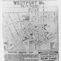
Photograph of the 1855 "Westport, Mo. and Its Additions" map by Charles C. Spalding as it appeared in some publication dated January 16, 1947.
-
Date
-
1947-01-16
-
Object Type
-
Photograph
-

-
Title
-
Westport, Mo. & Its Additions
-
Description
-
Map of early Westport, with comments by the map's creator or cartographer, Charles Spalding.
-
Date
-
1855
-
Object Type
-
Book
-

-
Title
-
Spalding 1855 Map of Westport
-
Description
-
The 1855 Spalding map of Westport, Missouri, which hangs in the Special Collections Department as of September 26, 1974, is on indefinite loan to the Kansas City Public Library from the Daughters of Old Westport. Background information on the map is found in the local clubs collection, "SC 8."
-
Object Type
-
Archival Material
-

-
Title
-
Charles Spalding--Westport and Kansas City Town Booster
-
Description
-
File containing a photo and biographical article about Charles Carroll Spalding, or Charles Spalding (1826-1876), a pioneer promoter and writer of Kansas City. Native of Vermont coming to Kansas City in 1855 as city engineer (producing a famous map of Westport that year) and journalist for the Kansas City Enterprise, writing one of the city's first books in 1858, becoming city clerk in 1860, and dying partly from Civil War wounds.
-
Date
-
1996-04
-
Object Type
-
Magazine Article
