-

-
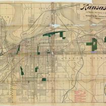
Title
-
Map Showing Paved and Macadamized Streets and Alleys and Street Railroads
-
Description
-
Map of Kansas City, Missouri, bordered by the Kansas and Missouri Rivers on the west and north, and by Woodland Avenue and 24th Street on the east and south, respectively. Street types (cedar block, stone, macadam pavement, etc.) indicated, as well as street railroad lines.
-
Date
-
1885
-
Object Type
-
Map
-

-
Title
-
Map of Greater Kansas City and Suburbs
-
Description
-
Street map of Kansas City area, including Rosedale and Kansas City, Kansas; North Kansas City, Independence, and Mount Washington in Missouri. Shows classes of roads, railroad lines, and streetcar lines as well as clubs and cemeteries. Includes index to streets and streetcar lines.
-
Date
-
1912
-
Object Type
-
Map
-

-
Title
-
1914 Map of Greater Kansas City
-
Description
-
Street map of Kansas City metropolitan area featuring successive circular lines in one mile intervals out from New Union Station. Rosedale, North Kansas City, Independence, and Kansas City, Kansas, are shown, with indexes to streets and street car lines.
-
Date
-
1914
-
Object Type
-
Map
-
-
Title
-
Park, Boulevard, Street Railway and Railway Map of Kansas City, Mo. and Kansas City, Kas.
-
Description
-
Street map of Kansas City, Missouri, and Kansas City, Kansas, showing parks, park districts, railroad and street car lines, etc. Inset map of the Midwest shows railroad lines converging on Kansas City.
-
Date
-
1894
-
Object Type
-
Map
-

-
Title
-
G. M. Hopkins' Map of Kansas City, Missouri
-
Description
-
Map of Kansas City showing major wards, streets, neighborhoods, subdivisions, railway lines, horse car lines, cable lines, and motor lines. Red ink markings added at a later date. Stamped at the top: "Compliments of Sweet Bros., Real Estate and Investments, Room 212 Alamo Building. Choice Business & Income Property a Specialty, Correspondence Solicited, Kansas City, Mo."
-
Date
-
1886
-
Object Type
-
Map
