-

-
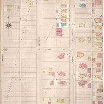
Title
-
Sanborn Map, Kansas City, Vol. 3, 1909-1957, Page p373
-
Description
-
A portion of Kansas City from E. 25th Street south to E. 26th Street and from Campbell Street east to Forest Avenue, showing buildings, streets, and additions. Large numbers at edges of page refer to page with adjoining area.
-
Date
-
1909/1957
-
Object Type
-
Map
-
-
Title
-
Sanborn Map, Kansas City, Vol. 3, 1896-1907, Page p296
-
Description
-
Southeastern part of early Kansas City from about E. 25th Street south to E. 27th Street and from Campbell Street east to Forest Avenue, showing buildings, streets, and additions. Large numbers at edges of page refer to page with adjoining area.
-
Date
-
1896/1907
-
Object Type
-
Map
-

-
Title
-
Troost Avenue Methodist Episcopal Church, South
-
Description
-
Folder contains a program for a ballad concert held at the Troost Avenue M.E. Church, South, February 3, 1898. Included various different performers.
-
Date
-
1898
-
Object Type
-
Archival Material
-

-
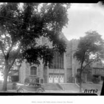
Title
-
Troost Avenue Methodist Church
-
Description
-
Full, street level view of the Troost Avenue Methodist Church located at 2536 Troost Avenue in Kansas City, Missouri.
-
Date
-
1952-05
-
Object Type
-
Negative