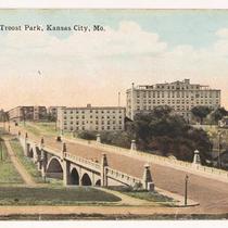
Pages
-

-
Title
-
Arly L. Hedrick Bridge and Troost Lake Marker
-
Description
-
The column "Postcards of Historic Northeast" features the Arly L. Hedrick Bridge as seen in 1921 at 27th Street. The bridge was built in 1919 in Troost Park by the firm of Hedrick & Hedrick and is now gone. "Troost Park was one of Kansas City's first amusement parks, originally opened in 1889 to bolster ridership for the Kansas City Cable Car Company". Column also includes two photographs of a marker at Troost Lake which commemorates the 1831 passage of Joseph Smith and his Mormon followers.
-
Date
-
2006-01-11
-
Object Type
-
Newspaper Article
-
-
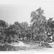
Title
-
Troost Park
-
Description
-
Troost Park in winter with leafless trees in Kansas City, Missouri. A car drives along road on right side of photo and a line of house is partially visible behind it.
-
Date
-
1916-02-20
-
Object Type
-
Photograph
-
-
Title
-
Troost Park, Bridge
-
Description
-
Postcard showing the Arly L. Hedrick Bridge at Troost Park.
-
Object Type
-
Postcard
-
-
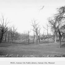
Title
-
Car near Troost Lake
-
Description
-
Car driving along lakeshore drive.
-
Date
-
1920
-
Object Type
-
Photograph
-
-
Title
-
Troost Park Boat House
-
Description
-
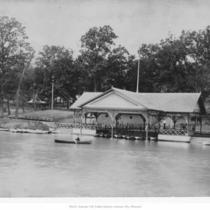
View of boat house from the lake; park located on a tract bounded by between 27th Street to the north, 31st Street to the south, Vine to the east, and Tracy to the west.
-
Date
-
1900
-
Object Type
-
Photograph
-

-
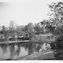
Title
-
Troost Park
-
Description
-
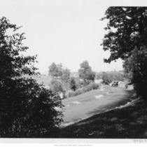
Looking north across lake to the 27th Street Viaduct.
-
Date
-
1920
-
Object Type
-
Photograph
-
-
Title
-
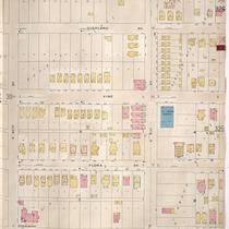
Sanborn Map, Kansas City, Vol. 3, 1896-1907, Page p302
-
Description
-
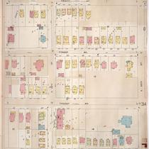
Southeastern part of early Kansas City from E. 29th Street south to about E. 30th Street and from Harrison Street east to Tracy Avenue, showing buildings, streets, and additions. Large numbers at edges of page refer to page with adjoining area.
-
Date
-
1896/1907
-
Object Type
-
Map
-
-
Title
-
Sanborn Map, Kansas City, Vol. 3, 1896-1907, Page p311
-
Description
-
Southeasernt part of early Kansas City from E. 29th Street south to E. 30th Street and from Lydia Avenue east to Highland Avenue, showing buildings, streets, and additions. Large numbers at edges of page refer to page with adjoining area.
-
Date
-
1896/1907
-
Object Type
-
Map
-

-
Title
-
Sanborn Map, Kansas City, Vol. 3, 1896-1907, Page p301
-
Description
-
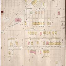
Southeastern part of early Kansas City from E. 27th Street south to about E. 29th Street and from Harrison Street east to Tracy Avenue, showing buildings, streets, and additions. Large numbers at edges of page refer to page with adjoining area.
-
Date
-
1896/1907
-
Object Type
-
Map
-
-
Title
-
Sanborn Map, Kansas City, Vol. 3, 1896-1907, Page p312
-
Description
-
Southeastern part of early Kansas City from E. 30th Street south to E. 31st Street and from Lydia Avenue east to Highland Avenue, showing buildings, streets, and additions. Large numbers at edges of page refer to page with adjoining area.
-
Date
-
1896/1907
-
Object Type
-
Map
-

-
Title
-
Kansas City's Coney Island
-
Description
-
Illustrations and text about the industrial exposition at Electric Park and the agricultural exposition at Troost Park.
-
Date
-
1902-07-27
-
Object Type
-
Newspaper Article
-

-
Title
-
Before Electric Park: A Promenade of Early Kansas City Area Amusement Parks
-
Description
-
The early Kansas City area parks featured in this article include: (1) Washington Park which was located in Independence, Missouri, and opened on July 4, 1887; (2) Fairmount Park which was located in the Fairmount section of Independence, Missouri and was opened in the 1890s by Arthur Stilwell; (3) Troost Park which was opened in 1888 and located at 29th and Tracy, one block from the Troost Avenue cable line; (4) Forest Park located at the corner of Independence Avenue and Hardesty Avenue and was opened on June 14, 1903; (5) Chelsea Park located in Kansas City, Kansas, opening on July 4, 1887; and (6) Carnival Park located in Kansas City, Kansas, opening on May 25, 1907.
-
Date
-
2006
-
Object Type
-
Magazine Article
Pages