Pages
-

-
Title
-
Kansas City Art Institute
-
Description
-
Clippings, brochures, and information about the Institute.
-
Object Type
-
Vertical File
-

-
Title
-
College Names Sculpture Park for Oppenheimers
-
Description
-
Johnson County Community College announced that the lawn in front of the Nerman Museum of Contemporary Art will be renamed the Oppenheimer Sculpture Park. Marti and Tony Oppenheimer are the museum's largest donors, contributing almost $2.5 million over the past 19 years.
-
Date
-
2011-07-31
-
Object Type
-
Newspaper Article
-

-
Title
-
School Nicknames
-
Description
-
Nicknames for Kansas City football teams have been confusing to many followers. Central High--Blue Eagles; Westport--Tigers; East High--Greenies; Southwest High--Indians; Manual High--Vikings; Rockhurst High--Young Hawks; De La Salle Academy--Cavaliers; Pembroke--Pembrokers; North Kansas City High--Hornets; Lathrop Trade School--Traders; Rosedale High--Mt. Martians; Argentine High--Mustangs; Wyandotte High--Bulldogs; William Chrisman--Bears; Rockhurst College--Hawks; Kansas City, Kansas, Junior College--Blue Devils; Olathe High--Eagles; and Center High--Yellow Jackets.
-
Date
-
1929-11-06
-
Object Type
-
Newspaper Article
-

-
Title
-
Christian Education Guide
-
Description
-
Forty-two page insert into Metro Voice about the Christian schools in the metro area including colleges as well as grade and high schools.
-
Date
-
2007-04
-
Object Type
-
Newspaper Article
-
-
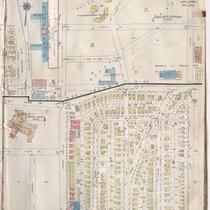
Title
-
Sanborn Map, Kansas City, Vol. 6, 1917-1957, Page p852
-
Description
-
A portion of Kansas City from E. 50th Street south to E. 51st Street and from Grand Avenue east to Holmes and a portion from Volker Drive south to E. 51st Street and from Rockhill Road east to Lydia Avenue, showing buildings, streets, and additions. Large numbers at edges of page refer to page with adjoining area. Noted at top of page, "Add'l Sheet Dec. 1933."
-
Date
-
1917/1957
-
Object Type
-
Map
-

-
Title
-
Sanborn Map, Kansas City, Vol. 2, 1940-1957, Page p245
-
Description
-
A portion of northeast Kansas City from Independence Boulevard south to E. 8th Street and from Euclid Avenue east to Brooklyn Avenue, showing buildings and streets. Large numbers at edges of pages refer to page with adjoining area.
-
Date
-
1940/1957
-
Object Type
-
Map
-

-
Title
-
Sanborn Map, Kansas City, Vol. 2, 1940-1950, Page p245
-
Description
-
A portion of northeast Kansas City from Independence Boulevard south to E. 8th Street and from Euclid Avenue east to Brooklyn Avenue, showing buildings and streets. Large numbers at edges of pages refer to page with adjoining area.
-
Date
-
1940/1950
-
Object Type
-
Map
-

-
Title
-
Metro-Comm. College Sub-Districts
-
Description
-
Map shows the boundaries of the Metropolitan Community College campus sub-districts in Kansas City.
-
Date
-
1992-10-22
-
Object Type
-
Map
-

-
Title
-
Metro-Comm. College Sub-Districts
-
Description
-
Map shows the boundaries of the Metropolitan Community College campus sub-districts in Kansas City.
-
Date
-
1982-05-25
-
Object Type
-
Map
-
-
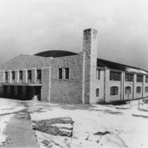
Title
-
Rockhurst College Campus
-
Description
-
Full view of the Mason-Halpin Fieldhouse located on the campus of what is now Rockhurst University at 1100 Rockhurst Road in Kansas City, Missouri.
-
Date
-
1940~/1949~
-
Object Type
-
Photograph
-

-
Title
-
Rockhurst College Campus
-
Description
-
Interior view of basketball game in progress in the Mason-Halpin Fieldhouse located on the campus of what is now Rockhurst University located at 1100 Rockhurst Road in Kansas City, Missouri.
-
Date
-
1940~/1949~
-
Object Type
-
Photograph
-

-
Title
-
Rockhurst College Chapel
-
Description
-
Interior view looking toward the altar area of the chapel located in Conway Hall on the campus of what is now Rockhurst University located at 1100 Rockhurst Road in Kansas City, Missouri.
-
Date
-
1940~/1949~
-
Object Type
-
Photograph
-
-
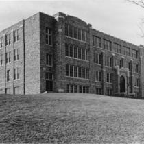
Title
-
Rockhurst College Campus
-
Description
-
Exteriior, full view of Conway Hall located on the campus of what is now Rockhurst University located at 1100 Rockhurst Road in Kansas City, Missouri.
-
Date
-
1940~/1949~
-
Object Type
-
Photograph
-

-
Title
-
University of Missouri-Columbia Campus
-
Description
-
Unframed, bird's eye view map (17.75 in. x 29.5 in.) of the University of Missouri-Columbia drawn by Arthur J. Elder. Coprighted in 1910 by W. T. Little & Co., New York. It is a buff color with brown inks.
-
Date
-
1910
-
Object Type
-
Archival Material
-

-
Title
-
Veterinary School Classroom Blackboard
-
Description
-
Interior view of a blackboard with drawing and identification of an unidentified animal spine, perhaps a horse. It is believed to have been taken at the Kansas City Veterinary College.
-
Date
-
1918~
-
Object Type
-
Photograph
-
-
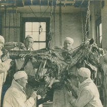
Title
-
Kansas City Veterinary College Class
-
Description
-
Interior view of a group of six male veterinary students studying what appears to be a partial horse carcass hanging from the ceiling. Believed to be part of a class taught at the Kansas City Veterinary School, which is listed in the 1917 Kansas City Directory as located at 1330-1336 E. 15th Street.
-
Date
-
1918~
-
Object Type
-
Photograph
-
-
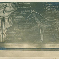
Title
-
Veterinary School Classroom Blackboard
-
Description
-
Interior, close-up view of what appears to be a classroom blackboard used for instruction at the Kansas City Veterinary College. Includes diagram of a complete horse on the right and perhaps a leg joint on the left.
-
Date
-
1918~
-
Object Type
-
Photograph
-

-
Title
-
A New Ballgame
-
Description
-
Avila University President Ron Slepitza said the improvements being made to the school "are part of a strategic plan that has been in the works for three or four years." The first improvements were new entrance signage, renovations to the anatomy and physiology labs, and an addition to Mabee Fieldhouse.
-
Date
-
2011-09-30
-
Object Type
-
Newspaper Article
Pages

