Skip to main content
Advanced Search
Select Collection
All collections
Images
Local History Index (Citations)
Search box
Home
Local History Blog
This Week in KC History
KC FAQs
Coloring Kansas City
Research Resources
Research Guides
Archival Collections
Educational Experiences
Digital Collections
About
Plan a Visit
Our Services
Donate Materials
Order Digital Files
Contact Us
You are here
Brink, McDonough & Company
(x)
1 to 3 of 3 Objects
Sort By:
Relevancy
Date
Title
Search results
Title
Township 48 North, Range 33 West of 5th Principal Meridian
Description
A plat map identifying property owners in Jackson County. Shows area south of 59th and east of Wornall.
Date
1877
Object Type
Map
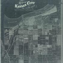
Title
Map of Kansas City and Suburbs
Description
Negative photocopy of a cadastral map showing plats in sections of the city.
Date
1877
Object Type
Map
Title
Township & Railroad Map of Missouri: Showing Congressional Townships, Principal Towns, Post Offices, Streams
Description
Map of Missouri showing counties in color. Also shows railroads, towns, and post offices, and lead mines. Includes tables showing 1860 and 1870 populations of counties and 1870 population for principal towns. Map does not actually show townships.
Date
1877
Object Type
Map
Refine Search
Object Type
Map
(3)
+
-
Local Subject
Maps
(3)
+
-
Atlases
(1)
+
-
Boundaries
(1)
+
-
Business Districts
(1)
+
-
Census
(1)
+
-
Counties
(1)
+
-
Jackson County Townships
(1)
+
-
Mining
(1)
+
-
Missouri
(1)
+
-
Population
(1)
+
-
Railroads
(1)
+
-
Real Estate
(1)
+
-
Residential Districts
(1)
+
-
Roads
(1)
+
-
Show more
Date
1877
(3)
+
-
Creator
Brink, McDonough & Company
(3)
+
-
Williams, John R.
(1)
+
-