-
-
Title
-
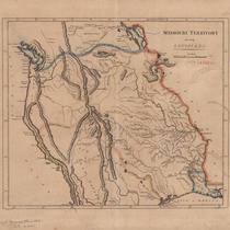
Missouri Territory, Formerly Louisiana
-
Description
-
Map shows area from Mississippi River westward, with rivers, mountains, locations of Native American tribes, and "probable north boundary" marked in blue and "probable south boundary marked in light pink and ivory. Eastern border of the Mississippi River highlighted in orange. Written in pencil in lower left corner, "Carey's General Atlas 1808? LC p 442."
-
Date
-
1808
-
Object Type
-
Map
-
-
Title
-
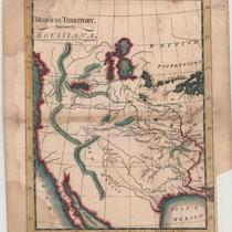
Missouri Territory, Formerly Louisiana
-
Description
-
Colored map shows area from Mississippi River westward, with rivers, mountains, and lakes indicated. Penciled note on map reads "Mo 1813."
-
Date
-
1813
-
Object Type
-
Map
