-

-
Title
-
Water Resources Development by the U. S. Army Corps of Engineers in Missouri
-
Description
-
Illlustrated article giving a description of the flood control projects of the Army Corps of Engineers in Jackson and Clay Counties, Missouri, on the Little Platte River for the new Smithville Lake and the Little Blue River, "authorized by the Flood Control Act of 1968," creating dams and water recreation at the new Little Blue River lakes of Blue Springs Lake and, on part of the land of the Longview Farm, Longview Lake.
-
Date
-
1979-01-01
-
Object Type
-
Report
-

-
Title
-
Water Resources Development by the U. S. Army Corps of Engineers in Missouri
-
Description
-
Description and photos of the new Truman Dam and Truman Lake "on the Osage River about 1 mile upstream from Warsaw, at the headwaters of the Lake of the Ozarks." Designed for flood control and hydroelectric energy along with the new Stockton Lake, both incidentally useful also for "outdoor recreation."
-
Date
-
1979
-
Object Type
-
Report
-

-
Title
-
Missouri River, Mouth to Kansas City
-
Description
-
Continuation of title, "Revision from Airplane Photographs, July 15, 1924. In 50 sheets. Sheet No. 49."Map shows a stretch of the Missouri River which includes Randolph Bend, Big Blue Bend, and Sissons Bend. Shows all principal topographic features for a minimum distance of 2000 feet inland, indicating levees, creeks, and railroad lines. The Missouri towns or sites of Cement City, Mt. Washington, Kansas City, Randolph, and Birmingham are in evidence. Standard Oil Co. intake noted, as well as the refinery.
-
Date
-
1924
-
Object Type
-
Map
-

-
Title
-
Missouri River, Kansas City to Sioux City
-
Description
-
Map of a stretch of the Missouri River between Waldron, Missouri, and Parkville, Missouri. Shows river soundings and principal topographic features between bluffs, and indicates older river bank lines (1890), levee lines, and railroad lines. The Kansas towns or stations of Wolcott or Connors City, Pomeroy, and Nearman are in evidence. Printed on the map, "Surveyed Nov.-Dec. 1922 E. A. B., Jun. Engr. In 47 sheets, Sheet No. 2. Made under the direction of Major C. C. Gee, Corps of Engineers, U.S.A. Submitted by E. C. Constance, Asst. Engr., U.S. Engineer Office, Kansas City, Mo."
-
Date
-
1922/1923
-
Object Type
-
Map
-

-
Title
-
Missouri River, Mouth to Kansas City
-
Description
-
Continuation of title, "Revision from Airplane Photographs, July 15, 1924. In 50 sheets. Sheet No. 48."Map shows a stretch of the Missouri River which includes Wayne City Bend, Liberty Bend, Mills Bend, and Jackson's Bend. Shows all principal topographic features for a minimum distance of 2000 feet inland, indicating levees, jetties, and creeks. The towns or stations of Courtney and South Liberty are in evidence, as well as Eton Tower, Atwood Quarry, and Liberty Water Works Pumping Station.
-
Date
-
1924
-
Object Type
-
Map
-
-
Title
-
Missouri River, Mouth to Kansas City
-
Description
-
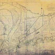
Continuation of title, "Revision from Airplane Photographs, July 15, Aug. 21, 1924. In 50 sheets. Sheet No. 50."Map of a stretch of the Missouri River from Quindaro Bend and the Fairfax Drainage District to the East Bottoms Bend. Shows all principal topographic features for a minimum distance of 2000 feet inland, indicating levees, jetties, creeks, and railroad lines. Goose Island, the Kansas River, Kaw Point, Kansas City, Kansas, Harlem, North Kansas City, Kansas City, Missouri, are in evidence.
-
Date
-
1924
-
Object Type
-
Map
-

-
Title
-
Missouri River, Kansas City to Sioux City
-
Description
-
Map of a stretch of the Missouri River between the Hannibal Bridge in Kansas City, Missouri, and the Quindaro Bend. Shows river soundings and principal topographic features between bluffs, and indicates older river bank lines (1890), levee lines, and railroad lines. Goose Island and the Kansas City Waterworks are in evidence. Printed on the map, "Surveyed Dec. 1922, E. A. B., Jun. Engr. In 47 sheets, Sheet No. 1. Made under the direction of Major C. C. Gee, Corps of Engineers, U.S.A. Submitted by E. C. Constance, Asst. Engr., U.S. Engineer Office, Kansas City, Mo."
-
Date
-
1922/1923
-
Object Type
-
Map
