Pages
-

-
Title
-
Sanborn Map, Kansas City, Vol. 3, 1909-1957, Page p368
-
Description
-
A portion of Kansas City from E. 26th Street south to E. 28th Street and from Main Street east to McGee Street, showing buildings, streets, and additions. Large numbers at edges of page refer to page with adjoining area.
-
Date
-
1909/1957
-
Object Type
-
Map
-

-
Title
-
Sanborn Map, Kansas City, Vol. 9, 1930-1941, Page p0942
-
Description
-
A portion of Kansas City from E. 59th Street south to E. 63rd Street and from Brooklyn Avenue east to Prospect Avenue, showing buildings, streets, and additions. Large numbers at edges of page refer to page with adjoining area.
-
Date
-
1930/1941
-
Object Type
-
Map
-

-
Title
-
Sanborn Map, Kansas City, Vol. 6, 1917-1957, Page p842
-
Description
-
A portion of Independence, Missouri from Short Street south to W. South Avenue and from Claremont east to Forest Avenue, showing buildings, streets, and additions. Large numbers at edges of page refer to page with adjoining area.
-
Date
-
1917/1957
-
Object Type
-
Map
-

-
Title
-
Sanborn Map, Kansas City, Vol. 6, 1917-1957, Page p839
-
Description
-
A portion of Kansas City from Independence Avenue south to about E. 10th Street and from Brookside Drive east to Overton Avenue, showing buildings, streets, and additions. Large numbers at edges of page refer to page with adjoining area.
-
Date
-
1917/1957
-
Object Type
-
Map
-

-
Title
-
Sanborn Map, Kansas City, Vol. 5, 1940-1941, Page p0628
-
Description
-
A portion of Kansas City from Anderson Avenue south to Independence Avenue and from Wheeling Avenue east to Bennington Avenue, showing buildings and streets. Large numbers at edges of page refer to page with adjoining area. Top of sheet indicates that this page number corresponds with pages 688, 712 and 714 in Vol. 5, 1909-1938.
-
Date
-
1940/1941
-
Object Type
-
Map
-
-
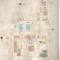
Title
-
Sanborn Map, Kansas City, Vol. 3, 1909-1957, Page p391
-
Description
-
A portion of Kansas City from E. 29th Street south to E. 30th Street and from Main Street east to McGee Street, showing buildings, streets, and additions. Large numbers at edges of page refer to page with adjoining area.
-
Date
-
1909/1957
-
Object Type
-
Map
-

-
Title
-
Sanborn Map, Kansas City, Vol. 3, 1909-1957, Page p403
-
Description
-
A portion of Kansas City from E. 28th Street south to E. 29th Street and from Michigan Avenue east to Brooklyn Avenue, showing buildings, streets, and additions. Large numbers at edges of page refer to page with adjoining area.
-
Date
-
1909/1957
-
Object Type
-
Map
-

-
Title
-
Sanborn Map, Kansas City, Vol. 3, 1909-1957, Page p381
-
Description
-
A portion of Kansas City from E. 25th Street south to E. 26th Street and from Garfield Avenue east to Olive Street, showing buildings, streets, and additions. Large numbers at edges of page refer to page with adjoining area.
-
Date
-
1909/1957
-
Object Type
-
Map
-

-
Title
-
Sanborn Map, Kansas City, Vol. 3, 1909-1957, Page p379
-
Description
-
A portion of Kansas City from E. 25th Street south to about E. 27th Street and from Woodland Avenue east to Garfield Avenue, showing buildings, streets, and additions. Large numbers at edges of page refer to page with adjoining area.
-
Date
-
1909/1957
-
Object Type
-
Map
-

-
Title
-
Sanborn Map, Kansas City, Vol. 5, 1940-1941, Page p1215
-
Description
-
A portion of Kansas City from E. 15th Street south to E. 19th Street and from Manchester Avenue east to Ashland Avenue, showing buildings and streets. Large numbers at edges of page refer to page with adjoining area. Indicated at top of sheet that this page number corresponds with pages 652, 707 and 710 in Vol. 5, 1909-1938.
-
Date
-
1940/1941
-
Object Type
-
Map
-

-
Title
-
Sanborn Map, Kansas City, Vol. 5, 1940-1941, Page p0601
-
Description
-
A portion of Kansas City from just north of E. 14th Street south to E. 15th Street and from Van Brunt Boulevard east to Colorado Avenue, showing buildings and streets. Large numbers at edges of page refer to page with adjoining area. Indicated at top of sheet that this page number corresponds with page 657 in Vol. 5, 1909-1938.
-
Date
-
1940/1941
-
Object Type
-
Map
-

-
Title
-
Sanborn Map, Kansas City, Vol. 5, 1940-1941, Page p1217
-
Description
-
A portion of Kansas City from E. 19th Street south to E. 25th Street and from Cleveland Avenue east to Kensington Avenue, showing buildings, streets and Mount St. Mary's Cemetery. Large numbers at edges of page refer to page with adjoining area. Indicated at top of sheet that this page number corresponds with pages 669, 670, 677 and 678 in Vol. 5, 1909-1938.
-
Date
-
1940/1941
-
Object Type
-
Map
-

-
Title
-
Map of Miami County, Kansas
-
Description
-
Map of Miami County, Kansas, showing roads, townships, railroads, cemeteries, pipelines, etc.
-
Date
-
1984
-
Object Type
-
Map
-

-
Title
-
Kansas City, Missouri
-
Description
-
Street map of Kansas City showing parks, cemeteries, park district boundaries, and street car lines.
-
Date
-
1926
-
Object Type
-
Map
-

-
Title
-
Road Map of Miami County, Kansas
-
Description
-
Road map of Miami County, Kansas, showing roads, townships, railroads, cemeteries, pipelines, etc.
-
Date
-
1983
-
Object Type
-
Map
-

-
Title
-
Fabulous Johnson County, Kansas
-
Description
-
Plat map of Johnson County, Kansas, with property owner names and includes roads, railroads, townships, schools, churches, cemeteries, etc.
-
Date
-
1965
-
Object Type
-
Map
-

-
Title
-
Kansas City Park, Boulevard, Street Railway and Railway Map of Kansas City, Mo. and Kansas City, Kas.
-
Description
-
Map of Kansas City, Missouri, and Kansas City, Kansas, showing parks, park districts, cemeteries, streets, railroad lines, and trolley lines. Inset map shows location of freight depots and express companies throughout the Midwest.
-
Date
-
1900
-
Object Type
-
Map
-

-
Title
-
Kansas City, Missouri School Districts
-
Description
-
Street map showing elementary, high schools and junior high schools. Also shows location of parks and cemeteries.
-
Date
-
1955
-
Object Type
-
Map
-

-
Title
-
Map of Forest Hill Cemetery, Kansas City
-
Description
-
Map of cemetery showing numbered sections, names of streets, and location of vaults. No key to individual plots. Below title: "Homer Reed, President. Organized 1888. George Law, Secretary."
-
Date
-
1888
-
Object Type
-
Map
Pages
