Pages
-

-
Title
-
Sanborn Map, Kansas City, Vol. 2, 1909-1937, Page p154
-
Description
-
A portion of Kansas City from Front Street south to E. 2nd Street and from Charlotte east to Harrison, showing buildings, streets, railroads, and additions. Large numbers at edges of page refer to page with adjoining area.
-
Date
-
1909/1937
-
Object Type
-
Map
-

-
Title
-
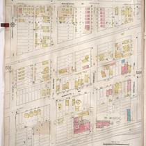
Sanborn Map, Kansas City, Vol. 2, 1909-1937, Page p153
-
Description
-
A portion of Kansas City Old Town from E. 1st Street south to E. 2nd Street and from Cherry Street east to Charlotte, showing buildings, streets, railroads, and additions. Large numbers at edges of page refer to page with adjoining area.
-
Date
-
1909/1937
-
Object Type
-
Map
-

-
Title
-
Sanborn Map, Kansas City, Vol. 6, 1917-1957, Page p854
-
Description
-
A portion of the Intercity District between Kansas City, Missouri, and Independence, Missouri, from E. 11th Street south to E. 14th Street and from Glenwood Avenue east to Ralston Avenue, showing buildings, streets, and additions. Large numbers at edges of page refer to page with adjoining area. Noted at top of map, "Add'l Sheet, Nov. 1936. Independence."
-
Date
-
1917/1957
-
Object Type
-
Map
-

-
Title
-
Sanborn Map, Kansas City, Vol. 6, 1917-1957, Page p837
-
Description
-
A portion of the Intercity District connecting Kansas City, Missouri, and Independence, Missouri, from Morrell Avenue south to Independence Avenue and from Brookside Drive east to Overton Avenue, showing buildings, streets, and additions. Large numbers at edges of page refer to page with adjoining area.
-
Date
-
1917/1957
-
Object Type
-
Map
-

-
Title
-
Sanborn Map, Kansas City, Vol. 5, 1909-1938, Page p608
-
Description
-
A portion of Kansas City from Rochester Avenue south to Guinotte Avenue and from N. Montgall Avenue east to Guinotte Avenue, showing buildings, streets, railroads, and additions. Large numbers at edges of page refer to page with adjoining area.
-
Date
-
1909/1938
-
Object Type
-
Map
-

-
Title
-
Sanborn Map, Kansas City, Vol. 1, 1909-1938, Page p039
-
Description
-
A portion of Kansas City from W. 11th Street south to W. 13th Street Terrace and from Mulberry east to Franklin Street, showing buildings, streets, railroads, and additions. Large numbers at edges of page refer to page with adjoining area.
-
Date
-
1909/1938
-
Object Type
-
Map
-
-
Title
-
Sanborn Map, Kansas City, Vol. 5, 1909-1938, Page p607
-
Description
-
A portion of Kansas City from Rochester Avenue south to Guinotte Avenue and from N. Wabash Avenue east to N. Montgall Avenue, showing buildings, streets, railroads, and additions. Large numbers at edges of page refer to page with adjoining area.
-
Date
-
1909/1938
-
Object Type
-
Map
-

-
Title
-
Sanborn Map, Kansas City, Vol. 1, 1909-1938, Page p006
-
Description
-
A portion of Kansas City from W. Front Street south to W. 3rd Street and from Delaware east to Main Street, showing buildings, streets, and additions. Large numbers at edges of page refer to page with adjoining area.
-
Date
-
1909/1938
-
Object Type
-
Map
-

-
Title
-
Sanborn Map, Kansas City, Vol. 1, 1909-1938, Page p005
-
Description
-
A portion of Kansas City from W. Front Street south to W. 3rd Street and from Wyandotte east to Delaware, showing buildings, streets, and additions. Large numbers at edges of page refer to page with adjoining area.
-
Date
-
1909/1938
-
Object Type
-
Map
-

-
Title
-
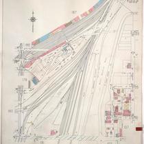
Sanborn Map, Kansas City, Vol. 6, 1917-1957, Page p833
-
Description
-
Index to New Report of Intercity District showing area connecting Kansas City, Missouri, and Independence, Missouri, as well as Sugar Creek district, dated December 1932. At bottom of sheet is a portion of Sugar Creek from Scarritt Avenue south to Kentucky Avenue and from Home Avenue east to Ralston Avenue, showing buildings, streets, and additions. Large numbers at edges of page refer to page with adjoining area. A new report for Sugar Creek is also attached dated November 1939.
-
Date
-
1917/1957
-
Object Type
-
Map
-

-
Title
-
Sanborn Map, Kansas City, Vol. 6, 1917-1957, Page p842
-
Description
-
A portion of Independence, Missouri from Short Street south to W. South Avenue and from Claremont east to Forest Avenue, showing buildings, streets, and additions. Large numbers at edges of page refer to page with adjoining area.
-
Date
-
1917/1957
-
Object Type
-
Map
-

-
Title
-
Sanborn Map, Kansas City, Vol. 6, 1917-1957, Page p839
-
Description
-
A portion of Kansas City from Independence Avenue south to about E. 10th Street and from Brookside Drive east to Overton Avenue, showing buildings, streets, and additions. Large numbers at edges of page refer to page with adjoining area.
-
Date
-
1917/1957
-
Object Type
-
Map
-

-
Title
-
Sanborn Map, Kansas City, Vol. 6, 1917-1957, Page p855
-
Description
-
A portion of the Intercity District between Kansas City, Missouri, and Independence, Missouri, from E. 14th Street south to E. 18th Street and from Arlington Avenue east to Maywood Avenue, showing buildings, streets, and additions. Large numbers at edges of page refer to page with adjoining area. Noted at top of map, "Add'l Sheet, Nov. 1936. Independence."
-
Date
-
1917/1957
-
Object Type
-
Map
-

-
Title
-
Sanborn Map, Kansas City, Vol. 6, 1917-1957, Page p840
-
Description
-
A portion of Kansas City from Independence Avenue south to E. 11th Street and from Overton Avenue east to S. Hardy Avenue, showing buildings, streets, and additions. Large numbers at edges of page refer to page with adjoining area.
-
Date
-
1917/1957
-
Object Type
-
Map
-

-
Title
-
Sanborn Map, Kansas City, Vol. 6, 1917-1957, Page p841
-
Description
-
A portion of Independence, Missouri, from Winner Road south to E. 20th Street and from Northern Boulevard east to Claremont, showing buildings, streets, and additions. Large numbers at edges of page refer to page with adjoining area.
-
Date
-
1917/1957
-
Object Type
-
Map
-

-
Title
-
Sanborn Map, Kansas City, Vol. 1A, 1939-1949, Page p165
-
Description
-
A portion of Kansas City from W. 27th Street south to Southwest Boulevard and from Bell Street east to Wyoming, showing buildings, streets, and railroads. Large numbers at edges of page refer to page with adjoining area.
-
Date
-
1939/1949
-
Object Type
-
Map
-
-
Title
-
Sanborn Map, Kansas City, Vol. 1A, 1939-1949, Page p188
-
Description
-
A portion of Kansas City from W. 9th Street south to W. 12th Street and from Santa Fe east to Jefferson, showing buildings, railroads and streets. Large numbers at edges of page refer to page with adjoining area.
-
Date
-
1939/1949
-
Object Type
-
Map
-

-
Title
-
Sanborn Map, Kansas City, Vol. 1A, 1939-1949, Page p168
-
Description
-
A portion of Kansas City from W. 21st Street south to W. 25th Street and from State Line east to Terrace Street, showing buildings, railroads, and streets. Large numbers at edges of page refer to page with adjoining area.
-
Date
-
1939/1949
-
Object Type
-
Map
-

-
Title
-
Sanborn Map, Kansas City, Vol. 2, 1940-1957, Page p279
-
Description
-
A portion of northeast Kansas City from E. Front Street south to Cliff Drive and from Lydia Avenue east to N. Woodland Avenue, showing buildings, parks, streets, and railroad lines. Shows N. Midtown Freeway. Large numbers at edges of pages refer to page with adjoining area.
-
Date
-
1940/1957
-
Object Type
-
Map
-
-
Title
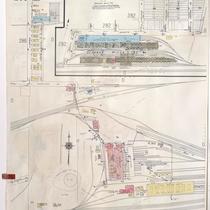
-
Sanborn Map, Kansas City, Vol. 2, 1940-1957, Page p285
-
Description
-
Portions of northeast Kansas City in the Missouri Pacific Railroad Company's yards and the General Mills Incorporated plant. Large numbers at edges of pages refer to page with adjoining area.
-
Date
-
1940/1957
-
Object Type
-
Map
Pages
