Pages
-
-
Title
-
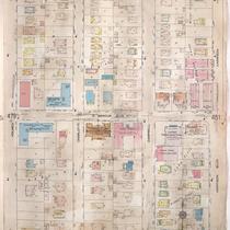
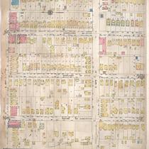
Sanborn Map, Kansas City, Vol. 4, 1909-1950, Page p480
-
Description
-
A portion of Kansas City from E. 34th Street south to E. 36th Street and from Holmes Avenue east to Harrison Boulevard, showing buildings, streets, and additions. Large numbers at edges of page refer to page with adjoining area.
-
Date
-
1909/1950
-
Object Type
-
Map
-

-
Title
-
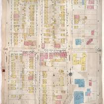
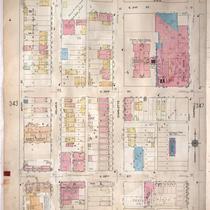
Sanborn Map, Kansas City, Vol. 3, 1909-1950, Page p319
-
Description
-
A portion of Kansas City from E. 17th Street south to E. 19th Street and from The Paseo east to Woodland Avenue, showing buildings, streets, and additions. Large numbers at edges of page refer to page with adjoining area.
-
Date
-
1909/1950
-
Object Type
-
Map
-
-
Title
-
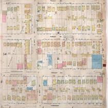
Sanborn Map, Kansas City, Vol. 4, 1909-1950, Page p547
-
Description
-
A portion of Kansas City from E. 45th Street south to E. 47th Street and from Forest Avenue east to The Paseo, showing buildings, streets, and additions. Large numbers at edges of page refer to page with adjoining area.
-
Date
-
1909/1950
-
Object Type
-
Map
-

-
Title
-
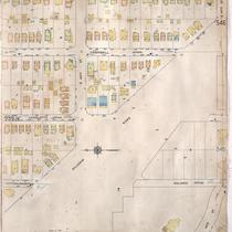
Sanborn Map, Kansas City, Vol. 4, 1909-1950, Page p553
-
Description
-
A portion of Kansas City from W. 41st Street south to W. 42nd Street and from State Line east to Terrace, showing buildings, streets, and additions. Large numbers at edges of page refer to page with adjoining area.
-
Date
-
1909/1950
-
Object Type
-
Map
-

-
Title
-
Sanborn Map, Kansas City, Vol. 4, 1909-1950, Page p490
-
Description
-
A portion of Kansas City from E. 35th Street south to E. 36th Street and from Montgall Avenue east to Agnes Avenue, showing buildings, streets, and additions. Large numbers at edges of page refer to page with adjoining area.
-
Date
-
1909/1950
-
Object Type
-
Map
-

-
Title
-
Sanborn Map, Kansas City, Vol. 4, 1909-1950, Page p470
-
Description
-
A portion of Kansas City from E. 31st Street south to E. 33rd Street and from Woodland Avenue east to Garfield Avenue, showing buildings, streets, and additions. Large numbers at edges of page refer to page with adjoining area.
-
Date
-
1909/1950
-
Object Type
-
Map
-

-
Title
-
Sanborn Map, Kansas City, Vol. 4, 1909-1950, Page p463
-
Description
-
A portion of Kansas City from E. 31st Street south to E. Linwood Boulevard and from Gillham Road east to Campbell Street, showing buildings, streets, and additions. Large numbers at edges of page refer to page with adjoining area.
-
Date
-
1909/1950
-
Object Type
-
Map
-

-
Title
-
Sanborn Map, Kansas City, Vol. 4, 1909-1950, Page p577
-
Description
-
A portion of Kansas City from W. 33rd Street south to W. 34th Street and from Holly Street east to Coleman Road, showing buildings, streets, and additions. Large numbers at edges of page refer to page with adjoining area. At top of map, "Add'l Sheet, Dec. 1921."
-
Date
-
1909/1950
-
Object Type
-
Map
-
-
Title
-
Sanborn Map, Kansas City, Vol. 4, 1909-1950, Page p542
-
Description
-
A portion of Kansas City from E. 44th Street south to E. 45th Street and from Harrison Street east to Tracy Avenue, showing buildings, streets, and additions. Large numbers at edges of page refer to page with adjoining area.
-
Date
-
1909/1950
-
Object Type
-
Map
-

-
Title
-
Sanborn Map, Kansas City, Vol. 4, 1909-1950, Page p564
-
Description
-
A portion of Kansas City from W. 44th Street Terrace south to W. 46th Street and from Madison Avenue east to Pennsylvania Avenue, showing buildings, streets, and additions. Large numbers at edges of page refer to page with adjoining area.
-
Date
-
1909/1950
-
Object Type
-
Map
-

-
Title
-
Sanborn Map, Kansas City, Vol. 4, 1909-1950, Page p534
-
Description
-
A portion of Kansas City from E. 41st Street south to E. 42nd Street and from Campbell Street east to Forest Avenue, showing buildings, streets, and additions. Large numbers at edges of page refer to page with adjoining area.
-
Date
-
1909/1950
-
Object Type
-
Map
-

-
Title
-
Sanborn Map, Kansas City, Vol. 4, 1909-1950, Page p567
-
Description
-
A portion of Kansas City from E. 36th Street south to about E. 37th Street and from Locust east to Janssen Place, showing buildings, streets, and additions. Large numbers at edges of page refer to page with adjoining area. At top of map, "Add'l Sheet, May 1912."
-
Date
-
1909/1950
-
Object Type
-
Map
-
-
Title
-
Sanborn Map, Kansas City, Vol. 4, 1909-1950, Page p540
-
Description
-
A portion of Kansas City from E. 44th Street south to E. 45th Street and from Kenwood Avenue east to Harrison Street, showing buildings, streets, and additions. Large numbers at edges of page refer to page with adjoining area.
-
Date
-
1909/1950
-
Object Type
-
Map
-
-
Title
-
Sanborn Map, Kansas City, Vol. 4, 1909-1950, Page p537
-
Description
-
A portion of Kansas City from E. 39th Street south to E. 40th Street and from Flora Avenue east to Michigan Avenue, showing buildings, streets, and additions. Large numbers at edges of page refer to page with adjoining area.
-
Date
-
1909/1950
-
Object Type
-
Map
-
-
Title
-
Sanborn Map, Kansas City, Vol. 3, 1909-1950, Page p345
-
Description
-
A portion of Kansas City from E. 21st Street south to E. 23rd Street and from McCoy Avenue east to Campbell, showing buildings, streets, and additions. Large numbers at edges of page refer to page with adjoining area.
-
Date
-
1909/1950
-
Object Type
-
Map
-

-
Title
-
Sanborn Map, Kansas City, Vol. 4, 1909-1950, Page p458
-
Description
-
A portion of Kansas City from W. Linwood Boulevard south to W. 34th Street and from Central Street east to Main Street, showing buildings, streets, and additions. Large numbers at edges of page refer to page with adjoining area.
-
Date
-
1909/1950
-
Object Type
-
Map
-

-
Title
-
Sanborn Map, Kansas City, Vol. 4, 1909-1950, Page p544
-
Description
-
A portion of Kansas City from E. 44th Street south to E. 45th Street and from Tracy Avenue east to Wayne Avenue, showing buildings, streets, and additions. Large numbers at edges of page refer to page with adjoining area.
-
Date
-
1909/1950
-
Object Type
-
Map
-

-
Title
-
Sanborn Map, Kansas City, Vol. 3, 1909-1950, Page p339
-
Description
-
A portion of Kansas City from E. 19th Street south to E. 21st Street and from College Avenue east to Bales Avenue, showing buildings, streets, and additions. Large numbers at edges of page refer to page with adjoining area.
-
Date
-
1909/1950
-
Object Type
-
Map
-

-
Title
-
Sanborn Map, Kansas City, Vol. 4, 1909-1950, Page p455
-
Description
-
A portion of Kansas City from W. 33rd Street south to W. 35th Street and from Coleman Road east to Jefferson Street, showing buildings, streets, and additions. Large numbers at edges of page refer to page with adjoining area.
-
Date
-
1909/1950
-
Object Type
-
Map
-

-
Title
-
Sanborn Map, Kansas City, Vol. 4, 1909-1950, Page p493
-
Description
-
A portion of Kansas City from Valentine Road south to W. 39th Street and from Roanoke Road east to Summit, showing buildings, streets, and additions. Large numbers at edges of page refer to page with adjoining area.
-
Date
-
1909/1950
-
Object Type
-
Map
Pages
