Pages
-
-
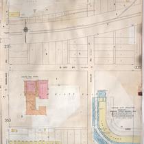
Title
-
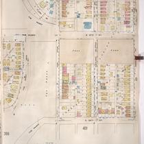
Sanborn Map, Kansas City, Vol. 3, 1909-1957, Page p378
-
Description
-
A portion of Kansas City from E. 27th Street south to E. 28th Street and from The Paseo east to Woodland Avenue, showing buildings, streets, and additions. Large numbers at edges of page refer to page with adjoining area.
-
Date
-
1909/1957
-
Object Type
-
Map
-

-
Title
-
Sanborn Map, Kansas City, Vol. 4, 1909-1957, Page p495
-
Description
-
A portion of Kansas City from Valentine Road south to W. 38th Street and from Belleview Avenue east to Jefferson, showing buildings, streets, and additions. Large numbers at edges of page refer to page with adjoining area.
-
Date
-
1909/1957
-
Object Type
-
Map
-

-
Title
-
Sanborn Map, Kansas City, Vol. 4, 1909-1957, Page p472
-
Description
-
A portion of Kansas City from E. 31st Street south to E. 33rd Street and from Olive Street east to Montgall Avenue, showing buildings, streets, and additions. Large numbers at edges of page refer to page with adjoining area.
-
Date
-
1909/1957
-
Object Type
-
Map
-
-
Title
-
Sanborn Map, Kansas City, Vol. 3, 1909-1957, Page p387
-
Description
-
A portion of Kansas City from E. 25th Street south to E. 26th Street and from Agnes Avenue east to Indiana Avenue, showing buildings, streets, and additions. Large numbers at edges of page refer to page with adjoining area.
-
Date
-
1909/1957
-
Object Type
-
Map
-

-
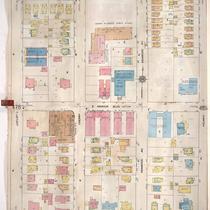
Title
-
Sanborn Map, Kansas City, Vol. 4, 1909-1957, Page p475
-
Description
-
A portion of Kansas City from W. 35th Street south to Valentine Road and from Jefferson Street east to Broadway, showing buildings, streets, and additions. Large numbers at edges of page refer to page with adjoining area.
-
Date
-
1909/1957
-
Object Type
-
Map
-

-
Title
-
Sanborn Map, Kansas City, Vol. 4, 1909-1957, Page p474
-
Description
-
A portion of Kansas City from W. 36th Street south to Valentine Road and from Belleview Avenue east to Jefferson Street, showing buildings, streets, and additions. Large numbers at edges of page refer to page with adjoining area.
-
Date
-
1909/1957
-
Object Type
-
Map
-

-
Title
-
Sanborn Map, Kansas City, Vol. 4, 1909-1957, Page p486
-
Description
-
A portion of Kansas City from E. 35th Street south to E. 36th Street and from Michigan Avenue east to Park Avenue, showing buildings, streets, and additions. Large numbers at edges of page refer to page with adjoining area.
-
Date
-
1909/1957
-
Object Type
-
Map
-

-
Title
-
Sanborn Map, Kansas City, Vol. 3, 1909-1957, Page p395
-
Description
-
A portion of Kansas City from E. 28th Street south to E. 29th Street and from Cherry Street east to Campbell Street, showing buildings, streets, and additions. Large numbers at edges of page refer to page with adjoining area.
-
Date
-
1909/1957
-
Object Type
-
Map
-

-
Title
-
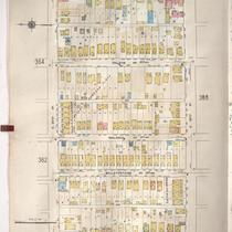
Sanborn Map, Kansas City, Vol. 3, 1909-1957, Page p368
-
Description
-
A portion of Kansas City from E. 26th Street south to E. 28th Street and from Main Street east to McGee Street, showing buildings, streets, and additions. Large numbers at edges of page refer to page with adjoining area.
-
Date
-
1909/1957
-
Object Type
-
Map
-

-
Title
-
Sanborn Map, Kansas City, Vol. 3, 1909-1957, Page p306
-
Description
-
A portion of Kansas City from Truman Road south to E. 17th Street and from Tracy Avenue east to The Paseo, showing buildings, streets, and additions. Large numbers at edges of page refer to page with adjoining area.
-
Date
-
1909/1957
-
Object Type
-
Map
-
-
Title
-
Sanborn Map, Kansas City, Vol. 4, 1909-1957, Page p479
-
Description
-
A portion of Kansas City from E. 34th Street south to E. 36th Street and from Locust east to Holmes Street, showing buildings, streets, and additions. Large numbers at edges of page refer to page with adjoining area.
-
Date
-
1909/1957
-
Object Type
-
Map
-

-
Title
-
Sanborn Map, Kansas City, Vol. 3, 1909-1957, Page p384
-
Description
-
A portion of Kansas City from E. 27th Street south to E. 28th Street and from Olive Street east to Prospect Avenue, showing buildings, streets, and additions. Large numbers at edges of page refer to page with adjoining area.
-
Date
-
1909/1957
-
Object Type
-
Map
-

-
Title
-
Sanborn Map, Kansas City, Vol. 4, 1909-1957, Page p488
-
Description
-
A portion of Kansas City from E. 35th Street south to E. 36th Street and from Park Avenue east to Montgall Avenue, showing buildings, streets, and additions. Large numbers at edges of page refer to page with adjoining area.
-
Date
-
1909/1957
-
Object Type
-
Map
-

-
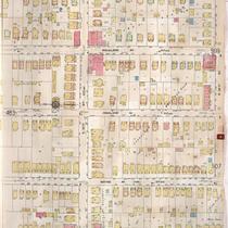
Title
-
Sanborn Map, Kansas City, Vol. 3, 1909-1957, Page p358
-
Description
-
A portion of Kansas City from E. 24th Street south to E. 25th Street and from Park Avenue east to Prospect Avenue, showing buildings, streets, and additions. Large numbers at edges of page refer to page with adjoining area.
-
Date
-
1909/1957
-
Object Type
-
Map
-
-
Title
-
Sanborn Map, Kansas City, Vol. 4, 1909-1957, Page p484
-
Description
-
A portion of Kansas City from E. 35th Street south to E. 36th Street and from Flora Avenue east to Michigan Avenue, showing buildings, streets, and additions. Large numbers at edges of page refer to page with adjoining area.
-
Date
-
1909/1957
-
Object Type
-
Map
-

-
Title
-
Sanborn Map, Kansas City, Vol. 3, 1909-1957, Page p316
-
Description
-
A portion of Kansas City from E. 17th Street south to E. 19th Street and from Charlotte east to Harrison, showing buildings, streets, and additions. Large numbers at edges of page refer to page with adjoining area.
-
Date
-
1909/1957
-
Object Type
-
Map
-

-
Title
-
Sanborn Map, Kansas City, Vol. 3, 1909-1957, Page p398
-
Description
-
A portion of Kansas City from E. 30th Street south to E. 31st Street and from Campbell Street east to Forest Avenue, showing buildings, streets, and additions. Large numbers at edges of page refer to page with adjoining area.
-
Date
-
1909/1957
-
Object Type
-
Map
-

-
Title
-
Sanborn Map, Kansas City, Vol. 3, 1909-1957, Page p302
-
Description
-
A portion of Kansas City from Truman Road south to E. 17th Street and from Grand Avenue east to Locust, showing buildings, streets, and additions. Large numbers at edges of page refer to page with adjoining area.
-
Date
-
1909/1957
-
Object Type
-
Map
-

-
Title
-
Sanborn Map, Kansas City, Vol. 3, 1909-1957, Page p340
-
Description
-
A portion of Kansas City from E. 19th Street south to E. 21st Street and from Bales Avenue east to Cleveland Avenue, showing buildings, streets, and additions. Large numbers at edges of page refer to page with adjoining area.
-
Date
-
1909/1957
-
Object Type
-
Map
-
-
Title
-
Sanborn Map, Kansas City, Vol. 3, 1909-1957, Page p334
-
Description
-
A portion of Kansas City from E. 19th Street Terrace south to E. 22nd Street and from Woodland Avenue east to Euclid Avenue, showing buildings, streets, and additions. Large numbers at edges of page refer to page with adjoining area.
-
Date
-
1909/1957
-
Object Type
-
Map
Pages
