-

-
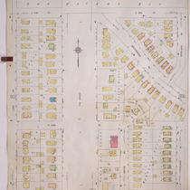
Title
-
Sanborn Map, Kansas City, Vol. 9, 1930-1957, Page p1025
-
Description
-
A portion of Kansas City from Charlotte Street east to Troost Avenue and E. 70th Street south to E. 76th Street Terrace, showing buildings, streets, and additions. Large numbers at edges of page refer to page with adjoining area.
-
Date
-
1930/1957
-
Object Type
-
Map
-

-
Title
-
Sanborn Map, Kansas City, Vol. 9, 1930-1957, Page p1011
-
Description
-
A portion of Kansas City from W. 73rd Street south to W. 76th Street and from State Line Road east to Jarboe Street, showing buildings, streets, and additions. Large numbers at edges of page refer to page with adjoining area.
-
Date
-
1930/1957
-
Object Type
-
Map
-
-
Title
-
Sanborn Map, Kansas City, Vol. 9, 1930-1957, Page p0903
-
Description
-
A portion of Kansas City from E. 51st Street south to E. 52nd Street and from Lydia Avenue east to Highland Avenue, showing buildings, streets, and additions. Large numbers at edges of page refer to page with adjoining area.
-
Date
-
1930/1957
-
Object Type
-
Map
-

-
Title
-
Sanborn Map, Kansas City, Vol. 9, 1930-1957, Page p1114
-
Description
-
A portion of Kansas City from E. 74th Street south to E. 77th Street and from Wayne Avenue east to Brooklyn Avenue, showing buildings, streets, and additions. Large numbers at edges of page refer to page with adjoining area. At top of map, "Add'l Sheet, May 1937."
-
Date
-
1930/1957
-
Object Type
-
Map
