Pages
-

-
Title
-
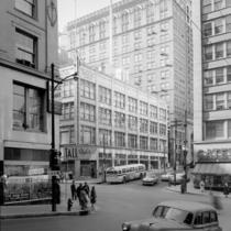
10th Street
-
Description
-
View looking toward the southwest of the south side of 10th Street between Main Street and Baltimore Avenue in downtown Kansas City, Missouri. The first of the two taller buildings is the Land Bank building, also known as the Riss building, located at 15 W. 10th Street. Next to it is the New England Bank building located at 21 W. 10th Street. The bank building later became the Hanover Lofts. In the foreground is Rothschild's department store.
-
Date
-
1950~
-
Object Type
-
Negative
-
-
Title
-
10th Street
-
Description
-
View of the intersection of 10th and Main streets in downtown Kansas City, Missouri. View includes the Rothschild's clothing store on the southwest corner of the intersection. West of it is the Riss building and a portion of the New England National Bank building. A Gateway Sporting Goods store can be seen on the northwest corner. A city bus is also in view.
-
Date
-
1950~
-
Object Type
-
Negative
-

-
Title
-
12th and Main Streets
-
Description
-
Looking north along Main Street from 12th Street. On the right is the southwest corner of the Jones Store building. Harzfeld's Department Store is visible one block south, and signs for King Joy Lo Restaurant, Liggett's Drugs, B & G Hosiery, Newman Theater, and Berkson's line the west side of the street from south to north. The block on the west side of Main was razed in the early 1970s and now occupied by City Center Square.
-
Date
-
1940~
-
Object Type
-
Negative
-

-
Title
-
Actor in Costume
-
Description
-
Actor seated in a chair, dressed in a Shakespearean costume.
-
Date
-
1920~
-
Object Type
-
Negative
-

-
Title
-
Actress Estelle Taylor
-
Description
-
Actress Estelle Taylor applying make-up in front of a mirror.
-
Date
-
1930~
-
Object Type
-
Negative
-

-
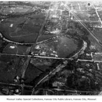
Title
-
Aerial View 11th and Baltimore
-
Description
-
Aerial view looking southwest from 11th Street and Baltimore Avenue. Shows Kansas City Club under construction and Convention Hall.
-
Date
-
1925
-
Object Type
-
Negative
-

-
Title
-
Aerial View of 26th and Broadway
-
Description
-
Aerial view looking northeast from 26th Street and Broadway Boulevard. Included in view are Union Station and Penn Valley Park.
-
Date
-
1920~
-
Object Type
-
Negative
-

-
Title
-
Aerial View of Columbus Park with Funeral Procession
-
Description
-
Aerial view of the Columbus Park neighborhood of Kansas City, Missouri. The area in view ranges from Charlotte Street on the left hand side of the image to Gillis Street on the right, and from 4th Street at the top of the image to Pacific Street at the bottom. The image shows an apparent funeral procession down Campbell Street to Holy Rosary Catholic Church.
-
Date
-
1934~
-
Object Type
-
Negative
-

-
Title
-
Aerial View of Downtown and West Bottoms Kansas City
-
Description
-
Aerial view of downtown Kansas City, Missouri, with the west portal of the 8th Street Tunnel in the left foreground. Quality Hill, the West Bluffs, a portion of the West Bottoms, and I-70 to the left and the 12th Street Bridge (viaduct) also appear. No print image; negative and digital only.
-
Object Type
-
Negative
-

-
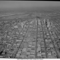
Title
-
Aerial View of Downtown Kansas City
-
Description
-
Aerial view of downtown Kansas City looking west with the Jackson County Courthouse and City Hall, two prominent buildings in the left foreground.
-
Object Type
-
Negative
-

-
Title
-
Aerial View of Downtown Kansas City
-
Description
-
Aerial view of downtown Kansas City with a portion of the West Bottoms in the foreground, looking east. No print image; negative and digital only.
-
Object Type
-
Negative
-

-
Title
-
Aerial View of Downtown Kansas City
-
Description
-
Aerial view of downtown Kansas City, Missouri, with the west portal of the 8th Street Tunnel in left foreground. Quality Hill, the West Bluffs, and I-70 to the left also appear. No print image; negative and digital only.
-
Date
-
1958-10-14
-
Object Type
-
Negative
-

-
Title
-
Aerial View of Downtown Kansas City
-
Description
-
Aerial view looking north with Union Station and Western Auto/Coca Cola building in the foreground and General Hospital to the right.
-
Date
-
1962-11-20
-
Object Type
-
Negative
-
-
Title
-
Aerial View of Downtown Kansas City
-
Description
-
Aerial view of downtown Kansas City and portions of North Kansas City, Missouri, looking toward the northwest. The Municipal Airport is in view as well as the Missouri River as it bends to the north. The Broadway Bridge, 2nd Hannibal Bridge, and the ASB Bridge, in that order from left to right, can be seen spanning the river. No print image; negative and digital only.
-
Date
-
1962-11-20
-
Object Type
-
Negative
-

-
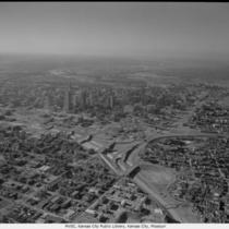
Title
-
Aerial View of Downtown Kansas City
-
Description
-
Aerial view of downtown Kansas City, Missouri, looking west with Interstate 70 (I-70) and northeast portion of the downtown loop on the right. No print image; negative and digital only.
-
Date
-
1962-11-20
-
Object Type
-
Negative
-
-
Title
-
Aerial View of Downtown Kansas City
-
Description
-
Aerial view of downtown Kansas City looking mostly west with Interstate 70 (I-70) on the right and the northeast loop. No print image; negative and digital only.
-
Date
-
1962-11-20
-
Object Type
-
Negative
-

-
Title
-
Aerial View of Downtown Kansas City
-
Description
-
Aerial view of downtown Kansas City looking west with Interstate 70 (I-70) on the right.
-
Date
-
1962-11-20
-
Object Type
-
Negative
Pages