
Maps and Atlases in the Missouri Valley Room
The map collection, with over 2000 maps, plat books, and atlases, covers the Kansas City region, Missouri, Kansas, the Midwest, trails, railroads, and early maps that identify Native American lands. They also include eastern states and rare maps of the early western hemisphere. Many maps are indexed in the Digital Gallery and some of these records include images. Additional atlases and maps can be found by searching the online catalog.
The Sanborn Fire Insurance Maps were created for fire insurance companies to assist them in assessing the risk of insuring a particular property. Today, however, they provide an important source for the study of the development of urban America beginning in the late 1800s. See our Sanborn map pages for information about the maps, a tutorial (PDF) on how to use the maps, an online exhibit (PDF), and more than 1200 images of the Kansas City Sanborn maps in the Digital Gallery. Sanborn maps for other cities and towns in Missouri and Kansas may be accessed through the Digital Sanborn Maps, 1867-1970 database (Kansas City Public Library card required to view from home).
Selected Kansas City atlases and plat books
The Atlas of the Environs of Kansas City, in Jackson County, Missouri for 1886, 1887 and 1891 [MVSC F 099.7 H79 on microfilm]
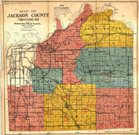
Plat Book of Jackson County Missouri for 1904 and 1911. [MVSC F 099.7 N87 1904; MVSC F 099.7 B53 1911 both also on microfilm]
Map pages (225), mounted on heavy boards, of the 1925 Atlas of Kansas City, Missouri, and Environs by Tuttle-Ayers-Woodward are stored in a wooden chest in the Missouri Valley Room. View online at Historic Maps Works, Residential Genealogy.
Family Maps of Jackson County, Missouri [MVSC 929.3 MS41BO], includes names of original land patent holders which can be used in conjunction with a search of the Federal Land Patent web page for original documents transferring the land.