Pages
-

-
Title
-
Plan of the City of Leavenworth, Kansas
-
Description
-
Map of Leavenworth including a numbered guide with city and county offices, railroad buildings, hotels, schools, and churches.
-
Date
-
1876
-
Object Type
-
Map
-

-
Title
-
Independence and Vicinity
-
Description
-
Map of Independence, Missouri, including named streets, roads, house numbers, schools, points of interest, etc.
-
Date
-
1949~
-
Object Type
-
Map
-

-
Title
-
Kansas City, Missouri School Districts
-
Description
-
Street map showing elementary, high schools and junior high schools. Also shows location of parks and cemeteries.
-
Date
-
1955
-
Object Type
-
Map
-

-
Title
-
Greater Kansas City
-
Description
-
Map of Kansas City including an alphabetical listing for named streets. Legend includes roads, railroads, parks, schools, ect.
-
Object Type
-
Map
-

-
Title
-
Wyandotte County, Kansas Street Map
-
Description
-
Street map of Wyandotte County, Kansas, including an index. Legend indicates schools, hospitals, parks, points of interest, railroads, streets, etc.
-
Object Type
-
Map
-

-
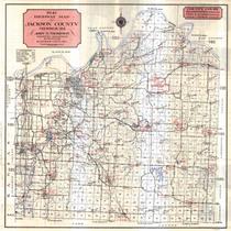
Title
-
Jackson County Street Map
-
Description
-
Map of Jackson County including highways, parks, schools, and an index of streets.
-
Object Type
-
Map
-

-
Title
-
The White River Country of Missouri: A Vacation Guide Map
-
Description
-
"Prepared by Missouri State Department of Resources and Development ." Detailed map of the White River Country area in southern Missouri. Legend includes cemeteries, schools, churches, roads, streams, etc.
-
Object Type
-
Map
-

-
Title
-
Jackson County, Missouri
-
Description
-
Map shows roads, railroad lines, schools, and political township lines of Jackson County, Missouri, and also shows proposed enlarged school districts, with some school districts unchanged.
-
Date
-
1920
-
Object Type
-
Map
-

-
Title
-
General Highway Map, Platte County, Missouri
-
Description
-
Map of Platte County, Missouri, including roads, streams, dams, bridges, parks, schools, and much more.
-
Date
-
1953
-
Object Type
-
Map
-

-
Title
-
Kansas City, Missouri
-
Description
-
Map of Kansas City showing streets, streetcar lines, railroads, schools, and school district boundaries.
-
Date
-
1930~
-
Object Type
-
Map
-

-
Title
-
Kansas City, Missouri School Districts
-
Description
-
Map of Kansas City, south of the river, demarcates school district boundaries for the Kansas City, MO, Independence, Blue Springs, Raytown, Center, Hickman Mills, Grandview, and Lee's Summit school districts.
-
Date
-
1982-05-01
-
Object Type
-
Map
-
-
Title
-
1941 Highway Map of Jackson County, Missouri
-
Description
-
Map of county, state and United States roads in Jackson County, Missouri, including rural schools, churches and cemeteries. Legend includes conditions of roads. Regional map of Kansas City on back.
-
Date
-
1941
-
Object Type
-
Map
-

-
Title
-
School Board Elections Polling Places
-
Description
-
Page 5 from the January 17, 1972 edition of the Kansas City Star. Map shows wards and polling places.
-
Date
-
1972-01-17
-
Object Type
-
Map
-

-
Title
-
The School District of Kansas City, Missouri
-
Description
-
Includes index with school name and address. Legend includes elementary, jr. high and senior high schools plus district wide facilities and non-academic buildings.
-
Date
-
1971
-
Object Type
-
Map
-

-
Title
-
Platte Co., Missouri
-
Description
-
Map of Platte County showing roads, railroads, towns, airports, township lines, streams, and schools. Includes list of county officials.
-
Date
-
1965~
-
Object Type
-
Map
Pages
