Pages
-

-
Title
-
Urban Renewal Projects in Kansas City, Missouri
-
Description
-
Street map of Kansas City (south of the Missouri River) showing urban renewal areas in color. Map is on a poster which includes before and after photos of urban renewal projects, statistics on projects, and a financial statement of the Land Clearance for Redevelopment Authority.
-
Date
-
1966
-
Object Type
-
Map
-

-
Title
-
Platte County Surburban Street Map
-
Description
-
Map of Platte County, Missouri, including a street index as well as roads, schools, parks, etc.
-
Date
-
1966
-
Object Type
-
Map
-

-
Title
-
Johnson Co. Suburban Area
-
Description
-
Map of Johnson County including a street index. Legend indicates roads, townships, schools, etc.
-
Date
-
1966
-
Object Type
-
Map
-

-
Title
-
Metropolitan Kansas City
-
Description
-
Blue-line map of the metropolitan Kansas City area, specifically Cass, Jackson, Clay, and Platte Counties in Missouri, and Wyandotte, Johnson, and a portion of Leavenworth Counties in Kansas. Map depicts area municipalities and major highways, including the proposals for Interstate 635, Interstate 470, and the southeast corner of Interstate 435.
-
Date
-
1966
-
Object Type
-
Map
-

-
Title
-
Old Oregon Trail
-
Description
-
Map includes historical sketches and information about the Oregon Trail.
-
Date
-
1959
-
Object Type
-
Map
-

-
Title
-
Kansas City, Missouri School Districts
-
Description
-
Map showing the boundary lines for Kansas City, Missouri schools. Roads, parks, streetcar, and rail lines are depicted, and schools are differentiated between "white schools" and "colored schools."
-
Date
-
1956
-
Object Type
-
Map
-

-
Title
-
Urban Renewal: Kansas City, Missouri
-
Description
-
Street map of downtown Kansas City, Missouri and vicinity showing urban renewal projects, redevelopment projects, existing & planned public housing, and freeway rights of way. Key incomplete; does not indicate meaning of colored blocks on map.
-
Date
-
1956
-
Object Type
-
Map
-

-
Title
-
Joseph Schlitz Brewing Company
-
Description
-
Plot plan showing layout of the Schlitz Brewing Company facility, located between 3rd and 5th, Grand and Locust streets in downtown Kansas City, Missouri.
-
Date
-
1956
-
Object Type
-
Map
-

-
Title
-
Zoning Map of Kansas City, Missouri
-
Description
-
Zoning map of Kansas City with shading indicating zoning districts. Key on map. "Red areas indicate the location of zoning changes during the period June 1952 to January 1956."
-
Date
-
1956
-
Object Type
-
Map
-

-
Title
-
Clay County Missouri
-
Description
-
Detailed map of Clay County, Missouri depicts county and city boundaries, interstates, state, and county highways, as well as many primary and secondary surface streets within particular localities. Also noted are parks, schools, hospitals, and townships. Of particular note is an illustration of the proposed site of the Smithville Reservoir in northern Clay County, which in 1979 became Smithville Lake.
-
Date
-
1965
-
Object Type
-
Map
-

-
Title
-
Kansas City Metropolitan Area
-
Description
-
Map of Kansas City area including Jackson, Cass, Clay, parts of Ray, Clinton, and Platte Counties in Missouri. Includes several counties on the Kansas side.
-
Object Type
-
Map
-
-
Title
-
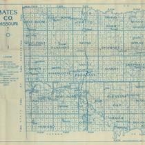
Bates CO. Missouri
-
Description
-
Map of Bates County, Missouri, that includes paved roads, graveled roads, state or county roads not highly improved, roads, interstates and highways, railroads, drainage district line, municipal township lines, streams, and schools. Includes the townships of West Boone, East Boone, Deer Creek, Grand River, Mingo, West Point, Elkhart, Mound, Shawnee, Spruce, Homer, Charlotte, Mount Pleasant, Summit, Deepwater, Walnut, New Home, Lone Oak, Pleasant Gap, Hudson, Howard, Osage, Prairie, and Rockville.
-
Object Type
-
Map
-

-
Title
-
America's Cattle Trails
-
Description
-
Map of trails including those used by the Spanish, pre-Civil War trails, Civil War routes, and other overland trails.
-
Date
-
1949
-
Object Type
-
Map
-

-
Title
-
Kansas City, Missouri
-
Description
-
Street map of Kansas City showing parks, cemeteries, park district boundaries, and street car lines.
-
Date
-
1940
-
Object Type
-
Map
Pages

