Pages
-

-
Title
-
Missouri: 150th Year
-
Description
-
Map of Missouri indicating county boundaries, possibly at the time of statehood in 1821. The map was prepared from documents located in the Missouri State Archives, and proceeds from its sale went to the Missouri Sesquicentennial Commission.
-
Date
-
1971-05-26
-
Object Type
-
Map
-

-
Title
-
A Literary Map of Missouri
-
Description
-
Map showing Missouri authors and books on a map of Missouri. Also includes additional authors on a list.
-
Date
-
1955-04
-
Object Type
-
Map
-

-
Title
-
Base Map of Missouri
-
Description
-
Map of Missouri including railroad lines, cities over 5,000, counties and county seats, and elevations.
-
Date
-
1940
-
Object Type
-
Map
-

-
Title
-
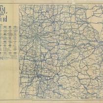
Official Road Map of Missouri
-
Description
-
Road map of Missouri showing the state highway system and the various types of roads within that system, including concrete, asphalt, brick, gravel, oiled, and graded earth. Map also shows cities and towns, parks, bodies of water, counties, schools, colleges and universities, and hospitals. Map includes insets of the Kansas City and Saint Louis metropolitan areas. Verso of map lists distances between cities along specific highways and the towns encountered along those routes.
-
Date
-
1936
-
Object Type
-
Map
-

-
Title
-
Missouri: The Show-Me State
-
Description
-
Map of Missouri with illustrations of important historical events and historical narrative in text around map.
-
Date
-
1935
-
Object Type
-
Map
-

-
Title
-
Shell Official Road Map of Missouri
-
Description
-
Road map of Missouri showing the state highway system and the various types of roads within that system, as well as state parks, points of interest, airports, and populations of cities and towns. Map also includes small portions of states bordering Missouri; a significant portion of southern Illinois including the cities of Springfield, Evansville; and part of Kansas as far west as Emporia. The reverse side of the map shows a Shell Transcontinental Mileage Chart and an Official Road Map of the United States. Also included are National Parks and monuments in the United States and Canada.
-
Date
-
1935
-
Object Type
-
Map
-

-
Title
-
Official Road Map of Missouri
-
Description
-
Map shows various kinds of roads in Missouri, indicating route numbers, road conditions, and points of interest. Towns, state parks, and toll bridges are also shown; reverse shows distances between various points.
-
Date
-
1931
-
Object Type
-
Map
-

-
Title
-
Official Road Map of Missouri
-
Description
-
Road map of Missouri showing state highway system including route numbers, road conditions, and points of interest. Various types of roads are included, as are counties, cities, and state parks. Reverse side of map depicts highway routes, scenic views of Missouri, and details of Kansas City and St. Louis.
-
Date
-
1927
-
Object Type
-
Map
-

-
Title
-
Soil Map of Missouri - Reconnaissance Survey
-
Description
-
Survey map of the state of Missouri provides detailed regional information about soil types (silt, clay, sand, etc.). Also included are locations of cities, rivers and lakes, railroads, and county lines.
-
Date
-
1918
-
Object Type
-
Map
-

-
Title
-
Base Map of Missouri
-
Description
-
Map of Missouri including railroad lines, cities over 5,000, counties and county seats, and elevations.
-
Date
-
1914
-
Object Type
-
Map
-

-
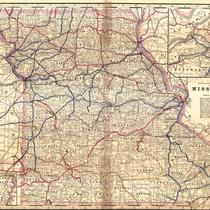
Title
-
Commissioners Official Railway Map of Missouri
-
Description
-
Continuation of title: Showing all Railway Lines and Stations; the County Boundaries and County Seats; also Congressional Townships, with Range and Township Numbers. Map shows color-coded 46 railroad lines, as well as railway mileage in Missouri for each line. Names of commissioners included.
-
Date
-
1904-04-01
-
Object Type
-
Map
-

-
Title
-
Mendenhall's Road Map of Missouri
-
Description
-
Continuation of title, "Showing Through Bicycle Routes in the State. Location of Towns, Post Offices, Railroads, &c." Map of Missouri showing bicycle through-routes, railroads, towns, counties, post offices, etc. Includes an enlargement of St. Louis.
-
Date
-
1902
-
Object Type
-
Map
-

-
Title
-
The Rand-McNally Vest Pocket Map of Missouri
-
Description
-
Title taken from original cover (now on the back of map) and continued, "Showing All Counties, Cities, Towns, Railways, Lakes, Rivers, etc." The map shows 46 railroad lines, keyed to numbers printed in red ink as well as a list of chief cities and their population. Back of map includes list of "Counties, Creeks, Rivers, and Towns" with square miles and population.
-
Date
-
1895
-
Object Type
-
Map
Pages