Pages
-

-
Title
-
18th and Vine: A Historical Map
-
Description
-
Illustrated map of area bounded by Parade Park, Woodland Avenue, 19th Street, and the Paseo. Reverse side features descriptions of the businesses and buildings depicted on the map.
-
Date
-
1990~
-
Object Type
-
Map
-
-
Title
-
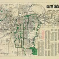
1914 Map of Greater Kansas City
-
Description
-
Street map of Kansas City metropolitan area featuring successive circular lines in one mile intervals out from New Union Station. Rosedale, North Kansas City, Independence, and Kansas City, Kansas, are shown, with indexes to streets and street car lines.
-
Date
-
1914
-
Object Type
-
Map
-
-
Title
-
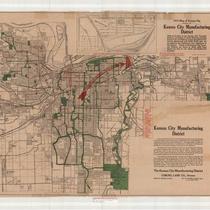
1914 Map of Kansas City, Showing the Kansas City Manufacturing District
-
Description
-
Map of greater Kansas City (including Independence, Missouri) with the Kansas City Manufacturing District indicated in red; street car lines are indicated in red, as well. An inset map shows an enlarged version of the Manufacturing District, with a freight station and railroad lines indicated, located just west of the Blue River and just south of Gladstone Boulevard.
-
Date
-
1914
-
Object Type
-
Map
-
-
Title
-
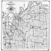
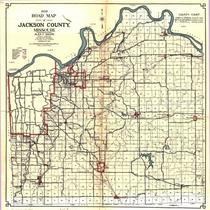
1921 Road Map of Jackson County, Missouri
-
Description
-
Map shows roads in Jackson County, Missouri. Legend indicates type of road (macadam, graded, etc.). Section lines and streams are also shown.
-
Date
-
1921
-
Object Type
-
Map
-

-
Title
-
1922 Road Map of Jackson County, Missouri
-
Description
-
Map showing roads in Jackson County, Missouri. Legend indicates type of road (macadam, graded, etc.). Section lines, electric lines, railroad lines, and streams are also shown. Only a few major roads in Kansas City are identified.
-
Date
-
1922
-
Object Type
-
Map
-

-
Title
-
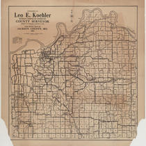
1923 Map of Road Overseer Districts of Jackson County, Missouri
-
Description
-
Map of Jackson County, Missouri, indicating surface conditions of roads, plus railroads, electric lines, streams, etc. Under title of map: "Leo E. Koehler. County Surveyor and Ex-officio County Highway Engineer of Jackson County, Missouri."
-
Date
-
1923
-
Object Type
-
Map
-
-
Title
-
1924 Road Map of Jackson County, MO.
-
Description
-
Map showing different types of roads (macadam, graded, oiled, and earth) as well as railroads, electric lines, section lines, towns, and streams in Jackson County, Missouri.
-
Date
-
1924
-
Object Type
-
Map
-
-
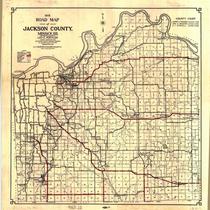
Title
-
1931 Road Map of Jackson County, Missouri
-
Description
-
Map showing roads in Jackson County, Missouri. Legend indicates kind of road (macadam, graded, etc.). Section lines, electric lines, railroad lines, schools, and streams are also shown. Only a few major roads in Kansas City are identified. Shows townships and ranges.
-
Date
-
1931
-
Object Type
-
Map
-
-
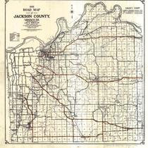
Title
-
1932 Road Map of Jackson County, Missouri
-
Description
-
Map showing roads in Jackson County, Missouri. Legend indicates kind of road (macadam, graded, etc.). Section lines, electric lines, railroad lines, schools, and streams are also shown. Only a few major roads in Kansas City are identified.
-
Date
-
1932
-
Object Type
-
Map
-

-
Title
-
1933 Road Map of Jackson County, Missouri
-
Description
-
Map shows roads in Jackson County, Missouri. Legend indicates kind of road (macadam, graded, etc.). Section lines, electric lines, railroad lines, schools, and streams are also shown. Only a few major roads in Kansas City are identified. Lists judges of the County Court, including Harry S. Truman, presiding judge.
-
Date
-
1933
-
Object Type
-
Map
-
-
Title
-
1934 Road Map of Jackson County, Missouri
-
Description
-
Map shows roads in Jackson County. Legend indicates kind of road (paved, oiled earth, state highway, etc.) Section lines, electric lines, railroad lines, schools, and streams also shown. Only a few major roads in Kansas City are identified. Lists judges of the County Court, including Harry S Truman, presiding judge.
-
Date
-
1934
-
Object Type
-
Map
-
-
Title
-
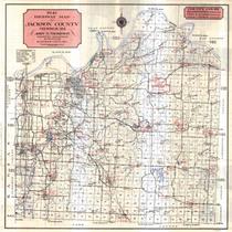
1941 Highway Map of Jackson County, Missouri
-
Description
-
Map of county, state and United States roads in Jackson County, Missouri, including rural schools, churches and cemeteries. Legend includes conditions of roads. Regional map of Kansas City on back.
-
Date
-
1941
-
Object Type
-
Map
-
-
Title
-
1941 Highway Map of Jackson County, Missouri
-
Description
-
Map of county, state and United States roads in Jackson County, Missouri, including rural schools, churches and cemeteries. Legend includes conditions of roads. Regional map of Kansas City on back.
-
Date
-
1941
-
Object Type
-
Map
-

-
Title
-
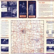
1963 Highway Map of Jackson County, Missouri
-
Description
-
Road map of Jackson County, Missouri depicting U.S., state, and county highways. Map also shows towns, smaller roads within towns outside Kansas City city limits, parks, bodies of water, schools, churches, cemeteries, railroads, significant buildings, and a township and range grid. Verso of map contains a highway map of most of Missouri and a portion of eastern Kansas as well as color photographs of Jackson County landmarks.
-
Date
-
1963
-
Object Type
-
Map
Pages