Pages
-

-
Title
-
1914 Map of Greater Kansas City
-
Description
-
Street map of Kansas City metropolitan area featuring successive circular lines in one mile intervals out from New Union Station. Rosedale, North Kansas City, Independence, and Kansas City, Kansas, are shown, with indexes to streets and street car lines.
-
Date
-
1914
-
Object Type
-
Map
-

-
Title
-
The Berry Company's Map of Kansas City, Kansas
-
Description
-
Land ownership map of the city of Kansas City, Kansas, showing steam and electric railways, parks, schools, cemeteries, businesses, and municipal buildings and landmarks.
-
Date
-
1910~
-
Object Type
-
Map
-

-
Title
-
Bird's Eye View - Kansas City
-
Description
-
Pictorial map showing the cities and towns of Kansas City, Missouri; Harlem, Missouri; Westport, Missouri; Rosedale, Kansas; Argentine, Kansas; Armourdale, Kansas; Armstrong, Kansas; Riverview, Kansas; Kansas City, Kansas; and Wyandotte, Kansas. At the time of its publication, the map had an extensive key listing the numbered buildings, most of which has been removed. Steamboats traveling along the Missouri River can be seen. The map displays the steep bluffs and topography of the region. It also indicates Kansas City's expansion southward away from the Missouri River, the development of the stockyards industry in the West Bottoms and interconnectivity with the surrounding cities and towns that followed completion of the Hannibal Bridge in 1869.
-
Date
-
1885~
-
Object Type
-
Map
-

-
Title
-
Central Industrial District, Kansas City, U.S.A.
-
Description
-
Map of central industrial district area including Kansas City, Missouri and Kansas City, Kansas at the confluence of the Missouri and Kansas Rivers. Shows stockyards, railroad yards, railroad lines, freight houses, street car lines, bus lines and major companies. Reverse side includes aerial views and text, with statistics, promoting the district.
-
Date
-
1936~
-
Object Type
-
Map
-

-
Title
-
Fairfax Industrial District and Environs
-
Description
-
Map of the Fairfax Industrial District and part of neighboring Kansas City, Kansas. The locations of various industrial concerns are shown, along with Fairfax Municipal Airport.
-
Date
-
1940
-
Object Type
-
Map
-

-
Title
-
Kansas City, Kansas
-
Description
-
Street map of Kansas City, Kansas, with indexes to streets, public and semi-public buildings, public schools and parochial schools. Large areas in color indicate industrial districts.
-
Date
-
1941
-
Object Type
-
Map
-

-
Title
-
Kansas City, Kansas: Formerly Wyandotte - Kansas City, Kan., and Armourdale
-
Description
-
Color copy of map of Kansas City, Kansas, showing the original areas of Wyandotte and Armourdale. Map includes additions, streets, businesses, schools, parks, cemeteries, railroads, the Kansas City Stockyards, and the Missouri and Kansas Rivers. Text on the map states
-
Date
-
1886
-
Object Type
-
Map
-

-
Title
-
Kansas City, Kansas: Formerly Wyandotte - Kansas City, Kan., and Armourdale
-
Description
-
Map of Kansas City, Kansas, showing the original areas of Wyandotte and Armourdale. Map includes additions, streets, businesses, schools, parks, cemeteries, railroads, the Kansas City Stockyards, and the Missouri and Kansas Rivers. Text on the map states it was approved by City Engineer and County Surveyor J. H. Lasley on October 15, 1886.
-
Date
-
1886
-
Object Type
-
Map
-

-
Title
-
Kansas City, Missouri, and Wyandott, Kansas
-
Description
-
Street map of Kansas City, Missouri, and Wyandott City (now Kansas City), Kansas. Map shows parks, railroad lines, and water treatment facilities. List of office holders for each city, as well as a legend listing points of interest (hotels, banks, theaters, etc.)
-
Date
-
1871
-
Object Type
-
Map
-

-
Title
-
Kansas City: Mobil Travel Map
-
Description
-
Street map of Kansas City and surrounding area including Wyandotte and Johnson counties in Kansas, North Kansas City, Independence, and Raytown; enlarged map of downtown inset. Indexes suburbs, points of interest, colleges, hospitals, transportation terminals, golf courses, parks, and streets. Includes two suggested tours of Kansas sites.
-
Date
-
1967
-
Object Type
-
Map
-

-
Title
-
Kansas City Sheet
-
Description
-
Topographical map of the Kansas City Metropolitan area at the turn of the century, including outlying areas of Platte and Clay counties in Missouri, and Wyandotte and Johnson counties in Kansas. Township boundaries are shown as are street grids for communities including Kansas City, Harlem, Parkville, Platte City, and Weston in Missouri, and Kansas City, Leavenworth, Merriam, and Shawnee in Kansas.
-
Date
-
1894
-
Object Type
-
Map
-

-
Title
-
Kansas City's Expressways
-
Description
-
Illustrated map showing the planned expressway system in the Kansas City area in 1952. Text printed on the map explains how the freeway system will work and how it will benefit the public. The map displays a plan to route the expressways close to the downtown area of Kansas City, Kansas, that was later changed.
-
Date
-
1952
-
Object Type
-
Map
-

-
Title
-
Map of Greater Kansas City and Suburbs
-
Description
-
Street map of Kansas City area, including Rosedale and Kansas City, Kansas; North Kansas City, Independence, and Mount Washington in Missouri. Shows classes of roads, railroad lines, and streetcar lines as well as clubs and cemeteries. Includes index to streets and streetcar lines.
-
Date
-
1912
-
Object Type
-
Map
-

-
Title
-
Map of Greater Kansas City and Suburbs
-
Description
-
Street map of the greater Kansas City area, including Kansas City, Kansas, Independence, North Kansas City, and large parts of Johnson County, Kansas.
-
Date
-
1927
-
Object Type
-
Map
-

-
Title
-
Map of Kansas City and Suburban Towns
-
Description
-
Black and white cadastral map shows political divisions including Kansas City, Missouri; Kansas City, Kansas; Westport, Missouri; and Wyandotte, Kansas; also shows roads, property owners, railroad lines, and some businesses. Under title: "S. F. Scott & Co. Real Estate and Loan Brokers."
-
Date
-
1881
-
Object Type
-
Map
-

-
Title
-
Map of Kansas City and Suburban Towns
-
Description
-
Two-color cadastral map shows political divisions including Kansas City, Missouri; Kansas City, Kansas; Westport, Missouri; and Wyandotte, Kansas; also shows roads, property owners, railroad lines, and some businesses. Under title: "S. F. Scott & Co. Real Estate and Loan Brokers."
-
Date
-
1881
-
Object Type
-
Map
-

-
Title
-
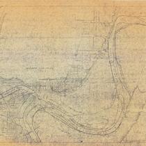
Missouri River Hydrographic Survey: Kaw Bend
-
Description
-
Map of the Kaw Bend of the Missouri River, curving around Fairfax Airport in Kansas City, Kansas. Soundings across the width of the river are listed at every tenth of a mile. Topographic features such as dikes, revetments, railroad lines are indicated, as well as major industrial sites along the river.
-
Date
-
1971
-
Object Type
-
Map
-
-
Title
-
Missouri River, Kansas City to Sioux City
-
Description
-
Map of a stretch of the Missouri River between the Hannibal Bridge in Kansas City, Missouri, and the Quindaro Bend. Shows river soundings and principal topographic features between bluffs, and indicates older river bank lines (1890), levee lines, and railroad lines. Goose Island and the Kansas City Waterworks are in evidence. Printed on the map, "Surveyed Dec. 1922, E. A. B., Jun. Engr. In 47 sheets, Sheet No. 1. Made under the direction of Major C. C. Gee, Corps of Engineers, U.S.A. Submitted by E. C. Constance, Asst. Engr., U.S. Engineer Office, Kansas City, Mo."
-
Date
-
1922/1923
-
Object Type
-
Map
Pages

