Pages
-
-
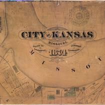
Title
-
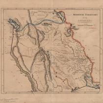
Missouri Territory, Formerly Louisiana
-
Description
-
Map shows area from Mississippi River westward, with rivers, mountains, locations of Native American tribes, and "probable north boundary" marked in blue and "probable south boundary marked in light pink and ivory. Eastern border of the Mississippi River highlighted in orange. Written in pencil in lower left corner, "Carey's General Atlas 1808? LC p 442."
-
Date
-
1808
-
Object Type
-
Map
-
-
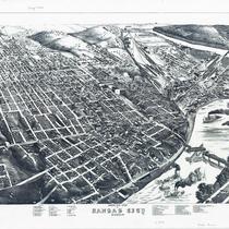
Title
-
Bird's Eye View of Kansas City, Missouri
-
Description
-
Aerial view of Kansas City from the northeast. Buildings, railroad lines, and other features rendered pictorially. Key at bottom of map identifies churches, schools, reservoirs, businesses, etc. Street names are shown. Hannibal Bridge is shown open for river traffic.
-
Date
-
1878
-
Object Type
-
Map
-

-
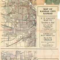
Title
-
Street Car, Trolley Bus and Motor Bus Lines Serving Greater Kansas City
-
Description
-
Map includes street car, motor bus, and trolley bus lines through Kansas City, MO, and linking to Kansas City, KS, Independence, MO, and North Kansas City, MO, and points of interest. Detailed inset map of downtown Kansas City, MO also notes railroad and bus terminals, airline and railroad ticket offices, churches, theaters, clubs, and hotels.
-
Date
-
1951
-
Object Type
-
Map
-

-
Title
-
Greater Kansas City
-
Description
-
Street map of Kansas City and surrounding area including Wyandotte and Johnson Counties in Kansas, North Kansas City, Independence, and Liberty in Missouri. Shows parks, airports, schools, hospitals, and police stations. Includes street index.
-
Date
-
1950~
-
Object Type
-
Map
-

-
Title
-
Missouri Official Highway Map
-
Description
-
Road map of Missouri showing the state highway system and the various type of roads within that system, as well as cities and towns according to population, points of interest, state parks, and national forests. The reverse side of the map shows St. Louis and vicinity and Kansas City and vicinity. Also included is the Missouri State Highway Patrol driving code and safety code for children. Mileage between cities for various routes are also listed.
-
Date
-
1938
-
Object Type
-
Map
-
-
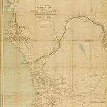
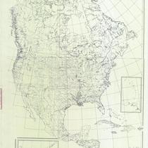
Title
-
Indian Tribes in North and Central America
-
Description
-
Blueprint of remarkably comprehensive map showing, apparently, all known locations of Indian tribes from the Arctic Circle to the northwest corner of South America, including the areas of present-day Canada, Alaska, United States, Mexico, West Indies, and Central America.
-
Object Type
-
Map
-

-
Title
-
Watson's New Sectional Map of Missouri
-
Description
-
Color shaded map of Missouri including information about Missouri government, townships, roads, railroads, an historical sketch of the state, and an insert of St. Louis.
-
Date
-
1870
-
Object Type
-
Map
-

-
Title
-
Map of Miami County, Kansas
-
Description
-
Map of Miami County, Kansas, showing roads, townships, railroads, cemeteries, pipelines, etc.
-
Date
-
1984
-
Object Type
-
Map
-
-
Title
-
Topography of Platte County, Missouri
-
Description
-
Title continues: "From U.S. geological survey topographic atlas sheets surveyed in 1906-1913 in cooperation with Missouri Bureau of Geology and Mines." Detailed topographic map of a large portion of Platte County, Missouri, and a section of the Missouri River which borders it. Bodies of water shown include the Platte River, the Little Platte River, Bean Lake, Iatan Pond, Wellson Slough, Wright Slough, Neirs Slough, Duck Lake, Slabtown Slough, Burns Lake, Horseshoe Lake, and Dry Lake. Railroad lines are in evidence including an electric railroad. Towns depicted are Dearborn, New Market, Camden Point, Bean Lake, Iatan, Weston, Platte City, Tracy, Linkville, Hampton, Tiffany Springs, Farley, Waldron, Barry, Parkville, Barrymoor, Northmoor, and Brenner. Many schools and churches are indicated.
-
Date
-
1914
-
Object Type
-
Map
-

-
Title
-
Greater Kansas City
-
Description
-
Street map of Kansas City and surrounding area including Wyandotte and Johnson counties in Kansas, North Kansas City, Independence, and Liberty. Shows parks, airports, schools, hospitals, and police stations. Includes street index.
-
Date
-
1950
-
Object Type
-
Map
-
-
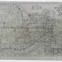
Title
-
Gallup's Map of Wyandotte County, Kansas
-
Description
-
Land ownership map of Wyandotte County, Kansas, showing county roads, roads, railroads, electric railroads, schools, churches, cemeteries, streams, and township boundaries, as well as drilling, oil, gas, dry, and abandoned wells. Includes the townships of Prairie, Quindaro, Wyandotte, Delaware, and Shawnee.
-
Date
-
1923
-
Object Type
-
Map
-

-
Title
-
Transportation Map and Guide of Greater Kansas City
-
Description
-
Map of bus and trolley lines in Kansas City dated May 1941; enlarged map of downtown area inset. Lines are identified by key on map. Also has list of points of interest.
-
Date
-
1941
-
Object Type
-
Map
Pages