Pages
-

-
Title
-
Clay County: Suburban Area
-
Description
-
Map of a part of Clay County from the Platte County line east to Liberty, and from the Missouri River north to Smithville. Drawn by hand is the boundary of the North Kansas City School District, December 9, 1964.
-
Date
-
1962
-
Object Type
-
Map
-

-
Title
-
Clay County: Suburban Area
-
Description
-
Map of part of Clay County, Missouri, showing roads, railroads, public transportation lines, hospitals, schools, and parks.
-
Date
-
1966
-
Object Type
-
Map
-

-
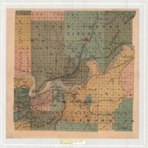
Title
-
Clay County, Missouri
-
Description
-
Map of Clay County, Missouri including parks, highways, schools, hospitals, railroads, etc.
-
Date
-
1965
-
Object Type
-
Map
-

-
Title
-
Official Highway Map of Clay County, Missouri
-
Description
-
Highly detailed map showing various classes of roads and railroads, levees, bridges, schools, dwellings (in rural areas), mines and quarries, etc. in Clay County, Missouri.
-
Date
-
1965
-
Object Type
-
Map
-

-
Title
-
Zoning Map of Kansas City, Missouri
-
Description
-
Zoning map of Kansas City with shading indicating zoning districts. Key on map. "Red areas indicate the location of zoning changes during the period June 1952 to January 1956."
-
Date
-
1956
-
Object Type
-
Map
-

-
Title
-
Kansas City Metropolitan Area
-
Description
-
Large scale map of metro area from Buchanan County, Missouri, in the north to Bates County in the south, and from Douglas County, Kansas in the west to Jackson County, Missouri in the east. Shows roads, township and section lines, parks, creeks and rivers. No detail within towns is shown.
-
Date
-
1955
-
Object Type
-
Map
-

-
Title
-
Kansas City and Vicinity
-
Description
-
Road map of Kansas City and surrounding counties including Ray and Buchanan counties in Missouri, Johnson and Leavenworth counties in Kansas; enlarged maps of St. Joseph, Mo. and Leavenworth, Kan. inset. Reverse side is street map of metropolitan Kansas City. Includes indexes to towns, airports, golf clubs, cemeteries, parks, lakes, and streets.
-
Date
-
1960
-
Object Type
-
Map
-

-
Title
-
Metropolitan Kansas City
-
Description
-
Map of Kansas City metropolitan area depicts Platte, Clay, Jackson, and Cass Counties in Missouri, and Johnson and Wyandotte Counties in Kansas. Interstate, state, and county highways are shown, as well as the city limits of numerous communities, including Kansas City, Independence, Raytown, Grandview, and Belton in Missouri, and Kansas City, Overland Park, Edgerton, Leavenworth, and Tonganoxie in Kansas.
-
Date
-
1966
-
Object Type
-
Map
-

-
Title
-
Kansas City Metropolitan Area
-
Description
-
Map of the Kansas City metropolitan area, showing boundaries of Kansas City and surrounding communities. Map also shows major roads and highways; proposed routes for Interstates 435, 35, 670, 635, and 470; proposed route for U.S. Highway 71; bodies of water; and airports.
-
Date
-
1960
-
Object Type
-
Map
-

-
Title
-
Map of Clay County, Missouri
-
Description
-
Map of Clay County, Missouri, including roads, schools, railroads, churches, streams, and townships. Includes list of county oficials at the top. At bottom of map: "Map No. M-938-24 361."
-
Date
-
1960~
-
Object Type
-
Map
-

-
Title
-
Street Map of Greater Kansas City
-
Description
-
Street map of Kansas City and surounding area, including portions of Platte and Clay counties in Missouri and portions of Wyandotte and Johnson counties in Kansas. Map also shows parks, bodies of water, railroads, and airports.
-
Date
-
1970~/1979~
-
Object Type
-
Map
-
-
Title
-
Kansas City and Surrounding Towns
-
Description
-
Map of Kansas City vicinity and many outlying towns. The city limits indicated for Kansas City, Missouri were inaugurated in 1885. Towns and townships are named and given distinctive colors; railroad lines as well as township section numbers are indicated. Includes Wyandotte County, Kansas, and Clay and Jackson Counties, Missouri.
-
Date
-
1890~
-
Object Type
-
Map
-
-
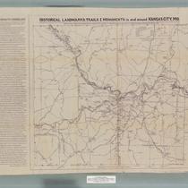
Title
-
Historical Landmarks, Trails & Monuments in and around Kansas City, Missouri
-
Description
-
Map created for the American Pioneer Trails Association with historical data provided by the Native Sons of Kansas City, Missouri, showing the locations of historical landmarks in the area. A Kawsmouth Chronology printed on the left hand side of the map provides a list of important dates in Kansas City history.
-
Date
-
1938
-
Object Type
-
Map
-

-
Title
-
Historical Landmarks, Trails & Monuments in and around Kansas City, Mo.
-
Description
-
Historic areas marked with associated dates including Indian campsites, battle fields, churches, cemeteries, forts, bridges, fords or ferries. Includes Clay, Jackson, and parts of Cass County in Missouri and Indian Territory in Kansas showing the Delaware, Wyandotte, and Shawnee Inidan areas. Along the left side is a chronological list of events, "Kawsmouth Chronology," from 1797 to 1869.
-
Date
-
1942
-
Object Type
-
Map
-

-
Title
-
Kansas City Metropolitan Area: Tour with Cities Service
-
Description
-
Road map of Kansas City and vicinity; indexes nearby cities and towns, points of interest, lakes, parks, rivers, airports, golf and country clubs. Reverse side includes maps of metropolitan Kansas City, downtown Kansas City, and a sight-seeing guide with suggested tours.
-
Date
-
1957
-
Object Type
-
Map
-
-
Title
-
Kansas City Metropolitan Area: For People Going Places
-
Description
-
Road map of Kansas City and vicinity; indexes nearby cities and towns, points of interest, lakes, parks, rivers, airports, golf and country clubs. Reverse side includes maps of metropolitan Kansas City, downtown Kansas City, and a sight-seeing guide with suggested tours.
-
Date
-
1962
-
Object Type
-
Map
-

-
Title
-
Kansas City and Vicinity
-
Description
-
Road map of Kansas City and vicinity, including Platte and Clay Counties, and Johnson, Wyandotte and Leavenworth Counties in Kansas. Indexes nearby cities and towns, points of interest, golf and country clubs, airports, lakes, and rivers. Reverse side features maps of metropolitan and downtown Kansas City, as well as a map of a suggested sight-seeing tour, with principal buildings and parks indicated.
-
Date
-
1962
-
Object Type
-
Map
Pages


