Pages
-
-
Title
-
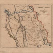
Missouri Territory, Formerly Louisiana
-
Description
-
Map shows area from Mississippi River westward, with rivers, mountains, locations of Native American tribes, and "probable north boundary" marked in blue and "probable south boundary marked in light pink and ivory. Eastern border of the Mississippi River highlighted in orange. Written in pencil in lower left corner, "Carey's General Atlas 1808? LC p 442."
-
Date
-
1808
-
Object Type
-
Map
-

-
Title
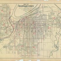
-
Street Car, Trolley Bus and Motor Bus Lines Serving Greater Kansas City
-
Description
-
Map includes street car, motor bus, and trolley bus lines through Kansas City, MO, and linking to Kansas City, KS, Independence, MO, and North Kansas City, MO, and points of interest. Detailed inset map of downtown Kansas City, MO also notes railroad and bus terminals, airline and railroad ticket offices, churches, theaters, clubs, and hotels.
-
Date
-
1951
-
Object Type
-
Map
-

-
Title
-
Missouri Official Highway Map
-
Description
-
Road map of Missouri showing the state highway system and the various type of roads within that system, as well as cities and towns according to population, points of interest, state parks, and national forests. The reverse side of the map shows St. Louis and vicinity and Kansas City and vicinity. Also included is the Missouri State Highway Patrol driving code and safety code for children. Mileage between cities for various routes are also listed.
-
Date
-
1938
-
Object Type
-
Map
-
-
Title
-
Indian Tribes in North and Central America
-
Description
-
Blueprint of remarkably comprehensive map showing, apparently, all known locations of Indian tribes from the Arctic Circle to the northwest corner of South America, including the areas of present-day Canada, Alaska, United States, Mexico, West Indies, and Central America.
-
Object Type
-
Map
-
-
Title
-
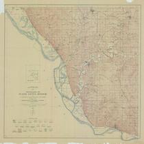
Topography of Platte County, Missouri
-
Description
-
Title continues: "From U.S. geological survey topographic atlas sheets surveyed in 1906-1913 in cooperation with Missouri Bureau of Geology and Mines." Detailed topographic map of a large portion of Platte County, Missouri, and a section of the Missouri River which borders it. Bodies of water shown include the Platte River, the Little Platte River, Bean Lake, Iatan Pond, Wellson Slough, Wright Slough, Neirs Slough, Duck Lake, Slabtown Slough, Burns Lake, Horseshoe Lake, and Dry Lake. Railroad lines are in evidence including an electric railroad. Towns depicted are Dearborn, New Market, Camden Point, Bean Lake, Iatan, Weston, Platte City, Tracy, Linkville, Hampton, Tiffany Springs, Farley, Waldron, Barry, Parkville, Barrymoor, Northmoor, and Brenner. Many schools and churches are indicated.
-
Date
-
1914
-
Object Type
-
Map
-

-
Title
-
Gallup's Map of Wyandotte County, Kansas
-
Description
-
Land ownership map of Wyandotte County, Kansas, showing county roads, roads, railroads, electric railroads, schools, churches, cemeteries, streams, and township boundaries, as well as drilling, oil, gas, dry, and abandoned wells. Includes the townships of Prairie, Quindaro, Wyandotte, Delaware, and Shawnee.
-
Date
-
1923
-
Object Type
-
Map
-

-
Title
-
Overland Trails
-
Description
-
Map depicts overland commerce and emigrant trails west of the Mississippi River. Includes Oregon, California, Mormon Pioneer, Lewis & Clark, Pony Express, Santa Fe, Old Spanish, Juan Bautista de Anza, El Camino Real de los Tejas, Nez Perce, El Camino Real de Tierra Adentro, and other trails and roads. Also includes cities, towns, and landmarks along trails.
-
Date
-
2005
-
Object Type
-
Map
-

-
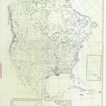
Title
-
Cleartype Outline Map of the United States
-
Description
-
Map of the United States showing railroads and rivers that originated in Kansas City. Depicted are railroads constructed to 1864 and projected railroads to 1864.
-
Object Type
-
Map
-

-
Title
-
Map of Kansas City and Suburban Towns
-
Description
-
Black and white cadastral map shows political divisions including Kansas City, Missouri; Kansas City, Kansas; Westport, Missouri; and Wyandotte, Kansas; also shows roads, property owners, railroad lines, and some businesses. Under title: "S. F. Scott & Co. Real Estate and Loan Brokers."
-
Date
-
1881
-
Object Type
-
Map
-
-
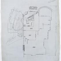
Title
-
Extension of City Limits Kansas City MO, At Different Periods
-
Description
-
Map identifying the areas annexed by the city of Kansas City, Missouri, in the years 1853, 1859, 1875, 1885, 1897, and 1909. The city limits in 1909 were the Missouri River south to 79th Street, and State Line Road east as far as Booth Avenue.
-
Date
-
1909
-
Object Type
-
Map
-
-
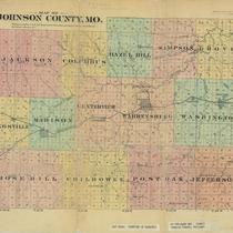
Title
-
Map of Johnson County, MO
-
Description
-
Map of Johnson County, Missouri, showing townships (in color), roads, railroads, post offices, schools, and churches.
-
Date
-
1881
-
Object Type
-
Map
-

-
Title
-
Lewis & Clark's West
-
Description
-
William Clark's 1810 master map of the American West is a full-size, color facsimile of the original manuscript map from the Yale collection of Western Americana in the Beinecke Rare Book and Manuscript Library, New Haven, Connecticut.
-
Date
-
2004
-
Object Type
-
Map
-

-
Title
-
Post Route Map of the States of Illinois, Iowa and Missouri
-
Description
-
Map subtitle states that map depicts "post offices, with the intermediate distances between them and mail routes in operation on the 1st February 1884". Map primarily depicts entire state of Iowa, with adjacent sections of neighboring states, including extreme northern Missouri, eastern Nebraska, Dakota Territory, southern Minnesota, southeast Wisconsin, and northern Illinois, and extreme northwest Indiana. The southern half of the map, depicting Kansas, Arkansas, and the majority of Missouri, has not been located. Map also includes counties in covered territory, railroad lines, and rivers. Outer boundaries of map denote latitude and longitude, as well as local time in relation to Washington, DC.
-
Date
-
1884
-
Object Type
-
Map
Pages