Pages
-
-
Title
-
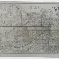
Gallup's Map of Wyandotte County, Kansas
-
Description
-
Land ownership map of Wyandotte County, Kansas, showing county roads, roads, railroads, electric railroads, schools, churches, cemeteries, streams, and township boundaries, as well as drilling, oil, gas, dry, and abandoned wells. Includes the townships of Prairie, Quindaro, Wyandotte, Delaware, and Shawnee.
-
Date
-
1923
-
Object Type
-
Map
-

-
Title
-
Lewis & Clark's West
-
Description
-
William Clark's 1810 master map of the American West is a full-size, color facsimile of the original manuscript map from the Yale collection of Western Americana in the Beinecke Rare Book and Manuscript Library, New Haven, Connecticut.
-
Date
-
2004
-
Object Type
-
Map
-
-
Title
-
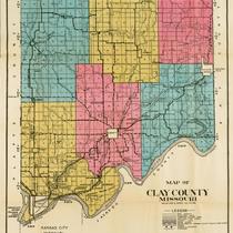
Map of Clay County Missouri
-
Description
-
Map of Clay County, Missouri, including railroads, electric lines, roads, schools, churches, and airports. Includes townships of Platte, Kearney, Washington, Gallatin, Liberty, and Fishing River. Includes cities of Liberty, Excelsior Springs, and North Kansas City. Also includes Kansas City Co. & St. Joe Electric Line.
-
Object Type
-
Map
-
-
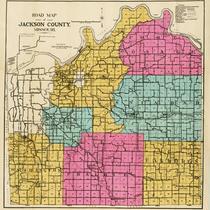
Title
-
Road Map of Jackson County, Missouri
-
Description
-
Road map of Jackson County, Missouri, that includes roads, railroads, electric lines, sections lines, streams, township lines, old trails, schools, and churches. Legend indicates types of roads shown. Includes townships of Blue, Fort Osage, Brooking, Sni-a-bar, Washington, Prairie, and Van Buren.
-
Object Type
-
Map
-

-
Title
-
Lewis and Clark Across Missouri: The Journey Begins
-
Description
-
Map of the state of Missouri depicting the journey of the Lewis and Clark Expedition from Fort Jefferson at the junction of the Ohio and Mississippi Rivers, up the Missouri River, from November, 1803 to July, 1804. Includes dates and locations of each expedition campsite, the hydrography of the Missouri River, land grants, forts, towns and villages of 1803-4.
-
Date
-
2002
-
Object Type
-
Map
-
-
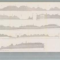
Title
-
Geologic Cross Sections of Kansas City and Jackson County
-
Description
-
Six cross sections of areas of Jackson County, Missouri, and Kansas City, Missouri, illustrate altitude above sea level and types of bedrock. Labels display locations of creeks and rivers, as well as major city thoroughfares including Southwest Boulevard, Armour Boulevard, and 75th Street.
-
Object Type
-
Map
-

-
Title
-
Lewis and Clark Across Missouri: The Journey Ends
-
Description
-
Map of the state of Missouri depicting the return journey of the Lewis and Clark Expedition down the Missouri River to St. Louis in September, 1806. Includes dates and locations of each expedition campsite, the hydrography of the Missouri River, land grants, forts, towns and villages of 1806.
-
Date
-
2002
-
Object Type
-
Map
-
-
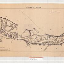
Title
-
Missouri River
-
Description
-
Map of a stretch of the Missouri River between Weston, Missouri, and Parkville, Missouri. Depicts islands, creeks, lakes, railroad lines, the Kansas towns of Leavenworth, Delaware, Connors City and the Missouri towns of Waldron and East Leavenworth. Also identifies some property owners.
-
Date
-
1878
-
Object Type
-
Map
-

-
Title
-
Road Map of Jackson County, Missouri
-
Description
-
Road map of Jackson County, Missouri, including the city of Kansas City and townships of Washington, Prairie, Van Buren, Sniabar, Fort Osage, Brooking, and Blue. Includes hard surface roads, graded roads, oiled roads, earth roads, railroads, electric lines, streams, old trails, and schools and churches. Handwritten notes from unknown source on front and back of map, labeling and other notes.
-
Object Type
-
Map
-
-
Title
-
Buchanan County, Missouri Map
-
Description
-
Land ownership map of Buchanan County, Missouri including the townships of Washington, Marion, Lake, Wayne, Center, Agency, Tremont, Rush, Bloomington, Crawford, Jackson, and Platte. Includes a key for "conventionals" such as roads, auto roads, railroads, railroads (electric), streams, schools. churches, and cemeteries.
-
Date
-
1920~
-
Object Type
-
Map
-
-
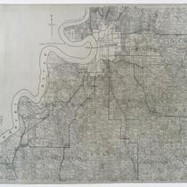
Title
-
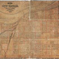
Map of the City of Kansas - Jackson County, Missouri
-
Description
-
Map of the City of Kansas, later known as Kansas City, in Jackson County, Missouri. Major streets, railroad lines, additions and subdivisions are marked. Landmarks and significant buildings are labeled. Harlem on the north side of the Missouri River in Clay County, Missouri, is shown.
-
Date
-
1880
-
Object Type
-
Map
-

-
Title
-
Missouri River: Mouth to Rulo
-
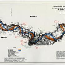
Description
-
Map of a stretch of the Missouri River between Quindaro Bend and Wayne City Bend, showing the principal topographic features within the alluvial valley. Contour intervals of 5 feet in the flood plain and 25 feet on the valley walls are indicated. Shows railroad yards around the Kansas River Bend and the Kansas City Reach, as well as levees, dikes, and railroad lines. The Missouri towns of North Kansas City, Avondale, Randolph, Minneville, Birmingham, and Sugar Creek are in evidence, along with Kansas City, Kansas.
-
Date
-
1946/1947
-
Object Type
-
Map
-

-
Title
-
Missouri River: Mouth to Rulo
-
Description
-
Map of a stretch of the Missouri River between Wayne City Bend and Missouri City Bend, showing principal topographic features within the alluvial valley. Contour intervals of 5 feet in the flood plain and 25 feet on the valley walls are indicated. Shows creeks, levees, dikes, and railroad lines. The Missouri towns of Birmingham, Cement City, South Liberty, Courtney, and Atherton are in evidence, as well as Big Shoal Creek and the Little Blue River.
-
Date
-
1946/1947
-
Object Type
-
Map
-

-
Title
-
Misssouri River: Mouth to Rulo
-
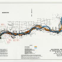
Description
-
Stretch of the Missouri River between Pope Bend and Quindaro Bend, showing principal topographic features within the alluvial valley. Contour intervals of 5 feet in the flood plain and 25 feet on the valley walls are indicated. Shows creeks, Wyandotte Lake, dikes, levees, railroad lines, the Kansas towns of Wolcott, Pomeroy, and Kansas City, and the Missouri town of Parkville.
-
Date
-
1946/1947
-
Object Type
-
Map
-
-
Title
-
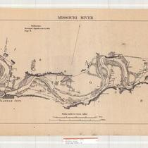
Missouri River
-
Description
-
Map of a stretch of the Missouri River between Quindaro, Kansas, and Missouri City, Missouri. Depicts islands, lakes, railroad lines, the Kansas towns of Wyandotte and Kansas City, and the Missouri towns of Kansas City, Wayne City, and Randolph. Also identifies some property owners.
-
Date
-
1878
-
Object Type
-
Map
Pages