Pages
-

-
Title
-
Cleartype Outline Map of the United States
-
Description
-
Map of the United States showing railroads and rivers that originated in Kansas City. Depicted are railroads constructed to 1864 and projected railroads to 1864.
-
Object Type
-
Map
-

-
Title
-
Missouri Territory, Formerly Louisiana
-
Description
-
Colored map shows area from Mississippi River westward, with rivers, mountains, and lakes indicated. Penciled note on map reads "Mo 1813."
-
Date
-
1813
-
Object Type
-
Map
-
-
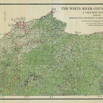
Title
-
The White River Country of Missouri: A Vacation Guide Map
-
Description
-
"Prepared by Missouri State Department of Resources and Development ." Detailed map of the White River Country area in southern Missouri. Legend includes cemeteries, schools, churches, roads, streams, etc.
-
Object Type
-
Map
-

-
Title
-
Kennett Quadrangle
-
Description
-
Topographical map of the Bootheel region of Missouri, including areas of Dunklin County in Missouri and Clay County in Arkansas. Kennett and Hornersville, Missouri and the Saint Francis River are featured, as weel as schools, cemeteries, and churches. Also shown are utility lines, dikes and levees along the river, and mills, factories, and other assorted buildings of interest.
-
Date
-
1940
-
Object Type
-
Map
-

-
Title
-
New Madrid Quadrangle
-
Description
-
Topographical map of areas of Stoddard and New Madrid counties in Missouri and Fulton County, Kentucky, including a segment of the Mississippi River and the city of New Madrid, Missouri. Also depicted are roads of varying grades, railroads, small communities, and levees and dikes along the Mississippi River.
-
Date
-
1939
-
Object Type
-
Map
-

-
Title
-
Map of the State of Missouri
-
Description
-
Map of Missouri showing counties, rivers, towns, mines, and general location of Indian tribes.
-
Date
-
1829
-
Object Type
-
Map
-

-
Title
-
Carte Geographique, Statistique et Historique du Missouri
-
Description
-
Map of Missouri with counties outlined in color. Shows towns, rivers, and mountains. French text on map gives information on climate, population, religion, transportation, commerce, and history. Map reads: "Fonderie et imprimerie de J. Carez."
-
Date
-
1820
-
Object Type
-
Map
-

-
Title
-
Map of Oregon, Washington, Idaho, and part of Montana
-
Description
-
Map of Oregon, Washington, Idaho, and part of Montana showing mountains and mountain passes, rivers, towns, counties in Oregon and Washington, and the Emigrant Road. A plate number, 44, appears at the lower right-hand corner of the map.
-
Date
-
1860
-
Object Type
-
Map
-

-
Title
-
Map of the Yellowstone and Missouri Rivers and Their Tributaries
-
Description
-
Continuation of title: explored by Capt. W. F. Raynolds Top[ographical] Eng[ineers] and 1st Lieut. H. E. Maynadier 10th Inf[antry] Assistant, 1859-60. To accompany a report to the Bureau of Topographical Engineers. Lt. Col. Hartman Bache in charge. Prepared to accompany the Geological Report of F. V. Hayden, M.D. Geologist to the Expedition.Includes the Cheyenne River, the Black Hills, the Bad Lands, Fort Laramie, the Little Missouri River, the Powder River, the Tongue River, the Big Horn River, the Big Horn Mountains, the Sweetwater River, the Wind River, the Platte River, the Popo Agie River, the Snake River, the Yellowstone River, the Missouri River, and the Three Forks of the Missouri River.
-
Date
-
1868
-
Object Type
-
Map
-

-
Title
-
Missouri River, Mouth to Kansas City
-
Description
-
Continuation of title, "Revision from Airplane Photographs, July 15, 1924. In 50 sheets. Sheet No. 49."Map shows a stretch of the Missouri River which includes Randolph Bend, Big Blue Bend, and Sissons Bend. Shows all principal topographic features for a minimum distance of 2000 feet inland, indicating levees, creeks, and railroad lines. The Missouri towns or sites of Cement City, Mt. Washington, Kansas City, Randolph, and Birmingham are in evidence. Standard Oil Co. intake noted, as well as the refinery.
-
Date
-
1924
-
Object Type
-
Map
-

-
Title
-
Missouri River, Kansas City to Sioux City
-
Description
-
Map of a stretch of the Missouri River between Waldron, Missouri, and Parkville, Missouri. Shows river soundings and principal topographic features between bluffs, and indicates older river bank lines (1890), levee lines, and railroad lines. The Kansas towns or stations of Wolcott or Connors City, Pomeroy, and Nearman are in evidence. Printed on the map, "Surveyed Nov.-Dec. 1922 E. A. B., Jun. Engr. In 47 sheets, Sheet No. 2. Made under the direction of Major C. C. Gee, Corps of Engineers, U.S.A. Submitted by E. C. Constance, Asst. Engr., U.S. Engineer Office, Kansas City, Mo."
-
Date
-
1922/1923
-
Object Type
-
Map
-

-
Title
-
A New Lewis and Clark Map
-
Description
-
Map drawn by Lewis and Clark depicts Missouri prior to its statehood, as well as surrounding frontier area, including territory now encompassed by Arkansas, Kansas, and other western states. Map shows the path of the Mississippi, Arkansas, Illinois, and other rivers, and shows general areas occupied by Indian tribes, including the Ozages (sic) and Arkansas.
-
Date
-
1961
-
Object Type
-
Map
-
![Thaxter's Map of the Two Kansas Citys [sic] of Missouri and Kansas](https://kchistory.org/sites/default/files/styles/islandora_imagecache_image_style_medium/public/externals/8b05940a47a4e406f9f68682bf90e68f.jpg?itok=tn2YrC-U&pid=kchistory:106613&iic=true&solr_nav%5Bid%5D=983896902617e0148068&solr_nav%5Bpage%5D=0&solr_nav%5Boffset%5D=15)
-
Title
-
Thaxter's Map of the Two Kansas Citys [sic] of Missouri and Kansas
-
Description
-
Street map of Kansas City, Missouri, and Kansas City, Kansas. Names of principal streets shown. Also shows parks, cemeteries, schools, railroad, cable car, and electric train lines as well as Quindaro and Argentine, Kansas, and Randolph and Harlem, Missouri.
-
Date
-
1890
-
Object Type
-
Map
-

-
Title
-
Portageville Quadrangle
-
Description
-
Topographical map of areas of New Madrid and Pemiscot counties in Missouri and Lake County in Tennessee, including the town of Portageville, Missouri, and a segment of the Mississippi River. Also included are roads of varying grades, railroads, river levees and dikes, as well as schools, churches, and cemeteries.
-
Date
-
1939
-
Object Type
-
Map
-

-
Title
-
Kirkwood Quadrangle
-
Description
-
Topographical map of an area of St. Louis County in eastern Missouri, including the town of Kirkwood and an adjacent segment of the Meramec River. Numerous schools, cemeteries, and churches are depicted, as well as small surrounding communities. Railroads and roads of varying degrees are shown.
-
Date
-
1940
-
Object Type
-
Map
-

-
Title
-
Independence
-
Description
-
Detailed topographical map of area east of Kansas City, showing parts of Clay, Ray, Jackson, and Lafayette Counties, Missouri. Some towns included are Kearney, Lawson, Vibbard, Excelsior Springs, Prathersville, Rayville, Liberty, Missouri City, Orrick, Camden, Independence, Randolph, Minaville, Liberty Landing, Sibley, Levasy, Pink Hill, Napoleon, Adams, Lake City, Buckner Hill, Oak Grove, Grain Valley, Blue Springs, Glendale, Raytown, Converse, Holt, Hainesville, Greensville, Clayville, Robertson, Knoxville, Swanwick, St. Cloud, Elkhorn, Crab Orchard. The Missouri River, Crooked River, Fishing River, numerous creeks and islands, and six railroad lines are featured. At bottom of map, "Edition of Jan. 1894, reprinted Mar. 1910. NOTE-Missouri River Compiled from Surveys made in 1879 Engineer Corps. U.S. Army. Independence, MO."
-
Date
-
1894
-
Object Type
-
Map
-

-
Title
-
St. Charles Quadrangle
-
Description
-
Topographical map of areas of St. Louis and St. Charles counties in Missouri and adjacent areas of Jersey and Madison counties in Illinois. Map also includes segments of the Missouri and Mississippi rivers, as well as the cities of St. Charles and Florissant, Missouri. Map also depicts additional area communities, schools, churches, farms, and minor airports, as well as roads of varying grades and railroads.
-
Date
-
1933
-
Object Type
-
Map
Pages


