-

-
Title
-
Kansas State Highway System
-
Description
-
Map of Kansas showing routes and route numbers for roads, also designating types of road surfaces (e.g. gravel, hard surface, earth, etc.).
-
Date
-
1929-04-01
-
Object Type
-
Map
-

-
Title
-
The Motor Trails of Kansas
-
Description
-
The Santa Fe Trail in the state of Kansas is detailed in this map. Shows counties and other roads and trails in the state.
-
Date
-
1912-08-12
-
Object Type
-
Map
-

-
Title
-
Continental Oil Co. Official Road Map of Missouri
-
Description
-
Road map of Missouri showing the state highway system and the various type of roads within that system, as well as cities and towns according to population. Map also shows small portions of states bordering Missouri and larger portions of Illinois and Kansas. The reverse side of the map shows a small Continental Oil Co. Road Map of the United States including a key to National Parks and Monuments. Also included is a list of Continental Oil Company Service Station locations throughout the country.
-
Object Type
-
Map
-
-
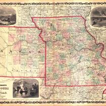
Title
-
Johnson's Missouri and Kansas
-
Description
-
Map of Missouri and the eastern third of Kansas, showing towns, rivers, roads, and railroads. Counties are shown in color; map is possibly a leaf from an atlas.
-
Date
-
1865
-
Object Type
-
Map
-
-
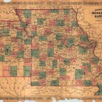
Title
-
Johnson's Missouri and Kansas
-
Description
-
Map of Missouri and the eastern third of Kansas. Counties shown in color. Shows towns, rivers, roads, and railroads. Possibly a leaf from an atlas. Illustrated with three engravings: Fire on the prairie; Santa Fe from the great Missouri Trail; and Spearing fish.
-
Date
-
1860
-
Object Type
-
Map
-

-
Title
-
The Judge Highway Map of Kansas
-
Description
-
Kansas map showing highways. Includes list of counties and population counts for 1910, 1920, and 1930 as well as population of cities and towns.
-
Date
-
1934
-
Object Type
-
Map
-

-
Title
-
Shell Official Road Map of Missouri
-
Description
-
Road map of Missouri showing the state highway system and the various types of roads within that system, as well as state parks, points of interest, airports, and populations of cities and towns. Map also includes small portions of states bordering Missouri; a significant portion of southern Illinois including the cities of Springfield, Evansville; and part of Kansas as far west as Emporia. The reverse side of the map shows a Shell Transcontinental Mileage Chart and an Official Road Map of the United States. Also included are National Parks and monuments in the United States and Canada.
-
Date
-
1935
-
Object Type
-
Map
