Pages
-

-
Title
-
Watson's New Sectional Map of Missouri
-
Description
-
Color shaded map of Missouri including information about Missouri government, townships, roads, railroads, an historical sketch of the state, and an insert of St. Louis.
-
Date
-
1870
-
Object Type
-
Map
-

-
Title
-
Map of Miami County, Kansas
-
Description
-
Map of Miami County, Kansas, showing roads, townships, railroads, cemeteries, pipelines, etc.
-
Date
-
1984
-
Object Type
-
Map
-
-
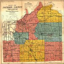
Title
-
Jackson County, Missouri
-
Description
-
Color shaded map showing townships, roads, railroads, streams, schools, and churches in Jackson County, Missouri.
-
Date
-
1916
-
Object Type
-
Map
-

-
Title
-
Map of Cass County, Missouri
-
Description
-
Map of Cass County showing townships in color. Also shows rivers, roads, sections lines, schools, and railroads.
-
Date
-
1883
-
Object Type
-
Map
-

-
Title
-
Road Map of Miami County, Kansas
-
Description
-
Road map of Miami County, Kansas, showing roads, townships, railroads, cemeteries, pipelines, etc.
-
Date
-
1983
-
Object Type
-
Map
-

-
Title
-
Fabulous Johnson County, Kansas
-
Description
-
Plat map of Johnson County, Kansas, with property owner names and includes roads, railroads, townships, schools, churches, cemeteries, etc.
-
Date
-
1965
-
Object Type
-
Map
-

-
Title
-
Clay County, Missouri
-
Description
-
Map of Clay County, Missouri including parks, highways, schools, hospitals, railroads, etc.
-
Date
-
1965
-
Object Type
-
Map
-

-
Title
-
Official Highway Map of Clay County, Missouri
-
Description
-
Highly detailed map showing various classes of roads and railroads, levees, bridges, schools, dwellings (in rural areas), mines and quarries, etc. in Clay County, Missouri.
-
Date
-
1965
-
Object Type
-
Map
-

-
Title
-
Regional Map of Greater Kansas City
-
Description
-
Regional map showing major roads, highways, towns, railways, and bodies of water in Jackson, Clay, Platte, Clinton (part), and Cass (part) counties in Missouri and Johnson, Wyandotte, Leavenworth, Atchison (part), and Douglas counties in Kansas. Map also shows townships and ranges for all the areas outside the boundaries of Kansas City, Missouri and Kansas City, Kansas.
-
Date
-
1930~
-
Object Type
-
Map
-

-
Title
-
1931 Road Map of Jackson County, Missouri
-
Description
-
Map showing roads in Jackson County, Missouri. Legend indicates kind of road (macadam, graded, etc.). Section lines, electric lines, railroad lines, schools, and streams are also shown. Only a few major roads in Kansas City are identified. Shows townships and ranges.
-
Date
-
1931
-
Object Type
-
Map
-

-
Title
-
Wyandotte County, Kansas Street Map
-
Description
-
Street map of Wyandotte County, Kansas, including an index. Legend indicates schools, hospitals, parks, points of interest, railroads, streets, etc.
-
Object Type
-
Map
-

-
Title
-
Texas County, Missouri
-
Description
-
Map of Texas County in Missouri showing townships, towns, section lines, roads, and railroads.
-
Date
-
1910~
-
Object Type
-
Map
-

-
Title
-
Platte Co., Missouri
-
Description
-
Map of Platte County showing roads, railroads, towns, airports, township lines, streams, and schools. Includes list of county officials.
-
Date
-
1965~
-
Object Type
-
Map
-

-
Title
-
Map of Clay County, Missouri
-
Description
-
Map of Clay County, Missouri, including roads, schools, railroads, churches, streams, and townships. Includes list of county oficials at the top. At bottom of map: "Map No. M-938-24 361."
-
Date
-
1960~
-
Object Type
-
Map
-

-
Title
-
Map of Greater Kansas City and Suburbs
-
Description
-
Street map of Kansas City area, including Rosedale and Kansas City, Kansas; North Kansas City, Independence, and Mount Washington in Missouri. Shows classes of roads, railroad lines, and streetcar lines as well as clubs and cemeteries. Includes index to streets and streetcar lines.
-
Date
-
1912
-
Object Type
-
Map
-

-
Title
-
1923 Map of Road Overseer Districts of Jackson County, Missouri
-
Description
-
Map of Jackson County, Missouri, indicating surface conditions of roads, plus railroads, electric lines, streams, etc. Under title of map: "Leo E. Koehler. County Surveyor and Ex-officio County Highway Engineer of Jackson County, Missouri."
-
Date
-
1923
-
Object Type
-
Map
-
-
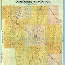
Title
-
Map of Nodaway County, Missouri
-
Description
-
Map showing townships in color, towns, roads, railroad lines, and waterways in Nodaway County, Missouri.
-
Date
-
1882
-
Object Type
-
Map
-

-
Title
-
Parker's Geological Map of the State of Missouri
-
Description
-
Title continues: "showing the location of the principal deposits of iron, lead, zinc, tin, copper, diamonds, gold, silver, platina, nickel, manganese, alabaster, kaolin, coal, oil springs, &c." Photocopy of a map of Missouri showing mineral deposits, railroads, roads, and towns. Includes tabular information giving population by county (1860 census), along with statistics of ore production.
-
Date
-
1865
-
Object Type
-
Map
-

-
Title
-
A New Map of Missouri with Its Roads and Distances
-
Description
-
Map of Missouri showing counties in color, towns, canals, roads, and railroads. At bottom of map is a list of steamboat routes. Distances between towns shown on map.
-
Date
-
1841
-
Object Type
-
Map
Pages

