Pages
-

-
Title
-
Greater Kansas City
-
Description
-
Street map of Kansas City and surrounding area including Wyandotte and Johnson counties in Kansas, North Kansas City, Independence, and Liberty. Shows parks, airports, schools, hospitals, and police stations. Includes street index.
-
Date
-
1950
-
Object Type
-
Map
-
-
Title
-
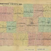
Map of Johnson County, MO
-
Description
-
Map of Johnson County, Missouri, showing townships (in color), roads, railroads, post offices, schools, and churches.
-
Date
-
1881
-
Object Type
-
Map
-

-
Title
-
Kansas City, Missouri, School Districts
-
Description
-
Street map of Kansas City showing grade school and high school district lines; locations of schools also shown.
-
Date
-
1946
-
Object Type
-
Map
-

-
Title
-
Clay County: Suburban Area
-
Description
-
Map of part of Clay County, Missouri, showing roads, railroads, public transportation lines, hospitals, schools, and parks.
-
Date
-
1966
-
Object Type
-
Map
-

-
Title
-
Johnson Co. Suburban Area
-
Description
-
Map of Johnson County including a street index. Legend indicates roads, townships, schools, etc.
-
Date
-
1966
-
Object Type
-
Map
-

-
Title
-
Kansas City, Missouri Location and Boundaries of Schools
-
Description
-
Small map of Kansas City, Missouri, showing schools and school district boundaries and some streets. Includes a list of high schools and their boundaries. In lower right corner: "Arranged and traced by students in mechanical drafting, Central High School, K.C. Mo., vocational department."
-
Date
-
1915
-
Object Type
-
Map
-

-
Title
-
Kansas City, Missouri
-
Description
-
Map of Kansas City showing streets, streetcar lines, railroads, schools, and school district boundaries.
-
Date
-
1930~
-
Object Type
-
Map
-

-
Title
-
Kansas City, Missouri School Districts
-
Description
-
Street map of Kansas City (south of the river) showing school district borders, grade school districts, locations of schools, and street car lines.
-
Date
-
1940
-
Object Type
-
Map
-

-
Title
-
Plan of the City of Leavenworth, Kansas
-
Description
-
Map of Leavenworth including a numbered guide with city and county offices, railroad buildings, hotels, schools, and churches.
-
Date
-
1876
-
Object Type
-
Map
-

-
Title
-
Independence and Vicinity
-
Description
-
Map of Independence, Missouri, including named streets, roads, house numbers, schools, points of interest, etc.
-
Date
-
1949~
-
Object Type
-
Map
-

-
Title
-
Kansas City, Missouri School Districts
-
Description
-
Street map showing elementary, high schools and junior high schools. Also shows location of parks and cemeteries.
-
Date
-
1955
-
Object Type
-
Map
-

-
Title
-
Greater Kansas City
-
Description
-
Map of Kansas City including an alphabetical listing for named streets. Legend includes roads, railroads, parks, schools, ect.
-
Object Type
-
Map
-

-
Title
-
Jackson County Street Map
-
Description
-
Map of Jackson County including highways, parks, schools, and an index of streets.
-
Object Type
-
Map
-

-
Title
-
The White River Country of Missouri: A Vacation Guide Map
-
Description
-
"Prepared by Missouri State Department of Resources and Development ." Detailed map of the White River Country area in southern Missouri. Legend includes cemeteries, schools, churches, roads, streams, etc.
-
Object Type
-
Map
-

-
Title
-
Jackson County, Missouri
-
Description
-
Map shows roads, railroad lines, schools, and political township lines of Jackson County, Missouri, and also shows proposed enlarged school districts, with some school districts unchanged.
-
Date
-
1920
-
Object Type
-
Map
-

-
Title
-
Kansas City, Missouri
-
Description
-
Map of Kansas City showing streets, streetcar lines, railroads, schools, and school district boundaries.
-
Date
-
1930~
-
Object Type
-
Map
Pages
