-

-
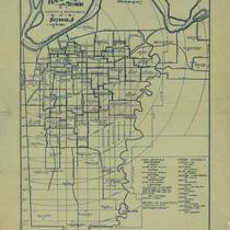
Title
-
Kansas City, Missouri, School Districts
-
Description
-
Street map of Kansas City showing grade school and high school district lines; locations of schools also shown.
-
Date
-
1946
-
Object Type
-
Map
-
-
Title
-
Kansas City, Missouri Location and Boundaries of Schools
-
Description
-
Small map of Kansas City, Missouri, showing schools and school district boundaries and some streets. Includes a list of high schools and their boundaries. In lower right corner: "Arranged and traced by students in mechanical drafting, Central High School, K.C. Mo., vocational department."
-
Date
-
1915
-
Object Type
-
Map
-

-
Title
-
Jackson County, Missouri
-
Description
-
Map shows roads, railroad lines, schools, and political township lines of Jackson County, Missouri, and also shows proposed enlarged school districts, with some school districts unchanged.
-
Date
-
1920
-
Object Type
-
Map
-

-
Title
-
Kansas City, Missouri School Districts
-
Description
-
Map of Kansas City, south of the river, demarcates school district boundaries for the Kansas City, MO, Independence, Blue Springs, Raytown, Center, Hickman Mills, Grandview, and Lee's Summit school districts.
-
Date
-
1982-05-01
-
Object Type
-
Map
-

-
Title
-
School Board Elections Polling Places
-
Description
-
Page 5 from the January 17, 1972 edition of the Kansas City Star. Map shows wards and polling places.
-
Date
-
1972-01-17
-
Object Type
-
Map
-

-
Title
-
Map of Clay County, Missouri
-
Description
-
Map of Clay County, Missouri, including roads, schools, railroads, churches, streams, and townships. Includes list of county oficials at the top. At bottom of map: "Map No. M-938-24 361."
-
Date
-
1960~
-
Object Type
-
Map
-
-
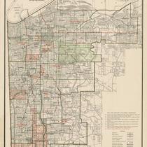
Title
-
Kansas City, Missouri, School Districts
-
Description
-
Street map of Kansas City showing grade school and high school districts as well as the locations of schools. The red Lines indicate high school boundaries and the "Colored" districts are marked in green.
-
Date
-
1951~
-
Object Type
-
Map
