-

-
Title
-
Sinclair 1935 Official Road Map Missouri
-
Description
-
One side of the fold-out map is a road map for the state of Missouri showing pennant flags to give the locations of Sinclair Pennant Hotels or Taverns. These are located in Columbia, Springfield, Rolla, and the Saint Louis area as well as in Tulsa and Miami, Oklahoma. The eastern portion of Kansas, northeast corner of Oklahoma, far north of Arkansas and parts of western Illinois are also shown. Missouri towns and population are listed. The opposite side of the map contains a major recreational road map of the United States with a list of national parks and monuments, military parks, battlefield sites, and cemeteries. This side also contains pictures of dinasaurs and an explanation of why Sinclair uses them. Also has a United States mileage chart.
-
Date
-
1935
-
Object Type
-
Map
-

-
Title
-
Missouri: The Show-Me State
-
Description
-
Map of Missouri with illustrations of important historical events and historical narrative in text around map.
-
Date
-
1935
-
Object Type
-
Map
-

-
Title
-
Kansas City Transportation Guide
-
Description
-
Brochure describing the public transportation system in Kansas City. One side is a street map showing the bus and street car routes, and including an index to points of interest. Reverse side contains descriptions of each bus and street car route and general information about the system, including fares, total miles covered, etc.
-
Date
-
1935
-
Object Type
-
Map
-
-
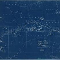
Title
-
Map of the Pony Express Trail
-
Description
-
Blue map (with white lettering) of the Pony Express Trail, including a list of Pony Express riders as well as some historical sketches.
-
Date
-
1935
-
Object Type
-
Map
-

-
Title
-
Piedmont Quadrangle
-
Description
-
Topographical map of areas of Reynolds, Carter, and Wayne counties in Missouri, including the town of Piedmont and segments of the Black and St. Francis rivers. Also depicted are roads of varying grades, railroads, schools, and churches.
-
Date
-
1935
-
Object Type
-
Map
-

-
Title
-
Knobby Creek Quadrangle
-
Description
-
Topographical map of areas of Benton, Morgan, and Camden counties in Missouri, adjacent to the Lake of the Ozarks. Numerous creeks feeding the lake are depicted, as are schools, churches, and camps.
-
Date
-
1935
-
Object Type
-
Map
-

-
Title
-
Shell Official Road Map of Missouri
-
Description
-
Road map of Missouri showing the state highway system and the various types of roads within that system, as well as state parks, points of interest, airports, and populations of cities and towns. Map also includes small portions of states bordering Missouri; a significant portion of southern Illinois including the cities of Springfield, Evansville; and part of Kansas as far west as Emporia. The reverse side of the map shows a Shell Transcontinental Mileage Chart and an Official Road Map of the United States. Also included are National Parks and monuments in the United States and Canada.
-
Date
-
1935
-
Object Type
-
Map
