-
-
Title
-
Proposed Master Plan
-
Description
-
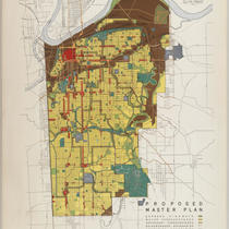
Proposed master plan for Kansas City, Missouri development, including highways, thoroughfares, neighborhood boundaries, residential areas, business & commercial areas, railroad and industrial areas, public spaces, and public schools and recreation areas. Map covers Kansas City, Missouri city limits south of the Missouri River, with connections shown to surrounding communities, including North Kansas City, Missouri, Johnson County, Kansas, and Raytown, Missouri.
-
Date
-
1946
-
Object Type
-
Map
-

-
Title
-
Shewey's Map - City St. Louis
-
Description
-
Map of the city of St. Louis showing streets, parks, ward boundaries, public buildings and institutions, railroad lines and depots, the Mississippi River, and routes for cable cars, electric cars, horse cars, and proposed elevated lines. Includes an inset map of Carondelet.
-
Date
-
1890
-
Object Type
-
Map
