-

-
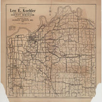
Title
-
Bird's Eye View - Kansas City
-
Description
-
Pictorial map showing the cities and towns of Kansas City, Missouri; Harlem, Missouri; Westport, Missouri; Rosedale, Kansas; Argentine, Kansas; Armourdale, Kansas; Armstrong, Kansas; Riverview, Kansas; Kansas City, Kansas; and Wyandotte, Kansas. At the time of its publication, the map had an extensive key listing the numbered buildings, most of which has been removed. Steamboats traveling along the Missouri River can be seen. The map displays the steep bluffs and topography of the region. It also indicates Kansas City's expansion southward away from the Missouri River, the development of the stockyards industry in the West Bottoms and interconnectivity with the surrounding cities and towns that followed completion of the Hannibal Bridge in 1869.
-
Date
-
1885~
-
Object Type
-
Map
-
-
Title
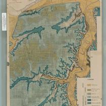
-
General Plan of Distribution System
-
Description
-
Map showing the water distribution system of Kansas City, Missouri, showing distribution lines, discharge lines, and low service lines. The Turkey Creek and proposed East Bottoms pumping stations and the Holly Street and Northeast reservoirs are indicated.
-
Date
-
1920
-
Object Type
-
Map
-
-
Title
-
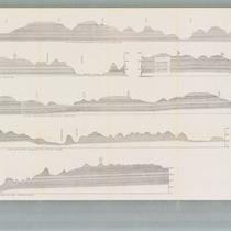
Geologic Cross Sections of Kansas City and Jackson County
-
Description
-
Six cross sections of areas of Jackson County, Missouri, and Kansas City, Missouri, illustrate altitude above sea level and types of bedrock. Labels display locations of creeks and rivers, as well as major city thoroughfares including Southwest Boulevard, Armour Boulevard, and 75th Street.
-
Object Type
-
Map
-

-
Title
-
Geological Map of Jackson County, Missouri
-
Description
-
Map detailing geological features of Kansas City. Different colors are used to show geological features and a street map is superimposed over the geological information.
-
Date
-
1917
-
Object Type
-
Map
-
-
Title
-
Geological Map of Kansas City, Missouri
-
Description
-
Map detailing geological features of Kansas City. Different colors are used to show geological features and a street map is superimposed over the geological information.
-
Date
-
1917
-
Object Type
-
Map
-
-
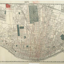
Title
-
Shewey's Map - City St. Louis
-
Description
-
Map of the city of St. Louis showing streets, parks, ward boundaries, public buildings and institutions, railroad lines and depots, the Mississippi River, and routes for cable cars, electric cars, horse cars, and proposed elevated lines. Includes an inset map of Carondelet.
-
Date
-
1890
-
Object Type
-
Map
-
-
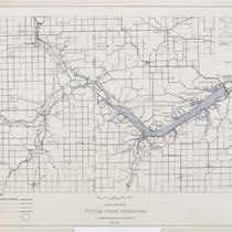
Title
-
Tuttle Creek Reservoir - Big Blue River, Kansas
-
Description
-
Map of Tuttle Creek Reservoir showing surrounding towns, roads, and proposed recreation areas. Inset map shows reservoir's location in Kansas. Reverse of map includes project data, mileage from various locations, and recreation information.
-
Date
-
1961-05
-
Object Type
-
Map
-
-
Title
-
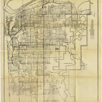
1924 Road Map of Jackson County, MO.
-
Description
-
Map showing different types of roads (macadam, graded, oiled, and earth) as well as railroads, electric lines, section lines, towns, and streams in Jackson County, Missouri.
-
Date
-
1924
-
Object Type
-
Map