-

-
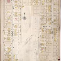
Title
-
Sanborn Map, Kansas City, Vol. 5, 1909-1938, Page p612
-
Description
-
A portion of Kansas City from Nicholson Avenue south to Rochester Avenue and from N. Montgall Avenue east to N. Kansas Avenue, showing buildings, streets, and additions. Large numbers at edges of page refer to page with adjoining area.
-
Date
-
1909/1938
-
Object Type
-
Map
-
-
Title
-
Sanborn Map, Kansas City, Vol. 2, 1896-1907, Page p216
-
Description
-
Northeastern part of early Kansas City from about Nicholson Avenue south to Rochester Avenue and from Montgall Avenue east to East Lynne Avenue, showing buildings, streets, and the area that was formerly Electric Park. Large numbers at edges of page refer to page with adjoining area.
-
Date
-
1896/1907
-
Object Type
-
Map
-

-
Title
-
Sanborn Map, Kansas City, Vol. 3, 1896-1907, Page p370
-
Description
-
Southeastern part of early Kansas City in the area of the second Electric Park opened in May, 1907 at Paseo Boulevard and 46th Street, showing streets, additions and park structures and attractions. Large numbers at edges of page refer to page with adjoining area. At top of map, "Add'l Sheet, June 1907."
-
Date
-
1896/1907
-
Object Type
-
Map
-
-
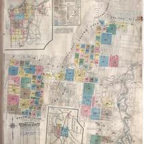
Title
-
Sanborn Map, Kansas City, Vol. 6, 1917-1945, Page f005
-
Description
-
Graphic Map of Volumes and Key to Sanborn Map of Kansas City, Vol. 6 (corrected to January 1946), showing Kansas City area bounded by E. 31st Street on the north, Elmwood Avenue on the east, 71st Street on the south, and the state line on the west. It also shows railroads, surrounding towns, parks, reservoirs, and indicates areas covered by other volumes.
-
Date
-
1917/1945
-
Object Type
-
Map
