Pages
-

-
Title
-
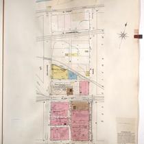
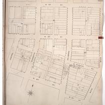
Sanborn Map, Kansas City, Vol. 2, 1896-1907, Page p112
-
Description
-
Northern part of early Kansas City in the River Market district from Main Street east to Oak Street and from E. 3rd Street south to Independence Avenue, showing buildings, streets, and City Hall. Large numbers at edges of page refer to page with adjoining area.
-
Date
-
1896/1907
-
Object Type
-
Map
-

-
Title
-
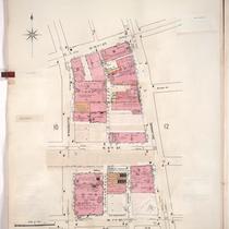
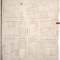
Sanborn Map, Kansas City, Vol. 2, 1909-1937, Page p152
-
Description
-
A portion of Kansas City Old Town from Front Street south to E. 3rd Street and from Grand Avenue east to Cherry, showing buildings, streets, railroads, and additions. Large numbers at edges of page refer to page with adjoining area.
-
Date
-
1909/1937
-
Object Type
-
Map
-

-
Title
-
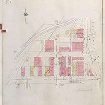
Sanborn Map, Kansas City, Vol. 1, 1909-1938, Page p004
-
Description
-
A portion of Kansas City from W. 3rd Street south to W. 5th Street and from Broadway east to Wyandotte, showing buildings, streets, and additions. Large numbers at edges of page refer to page with adjoining area.
-
Date
-
1909/1938
-
Object Type
-
Map
-

-
Title
-
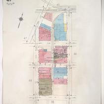
Sanborn Map, Kansas City, Vol. 2, 1896-1907, Page p112s
-
Description
-
Skeleton map of north part of early Kansas City in the River Market district from Main Street east to Oak Street and from E. 3rd Street south to Independence Avenue, showing outlines of buildings at the date of publication. These sheets were used to record new developments.
-
Date
-
1896/1907
-
Object Type
-
Map
-

-
Title
-
Sanborn Map, Kansas City, Vol. 2, 1909-1937, Page p157
-
Description
-
A portion of Kansas City Old Town from E. 3rd Street south to E. Missouri Avenue and from Main Street east to Walnut, showing buildings, streets and additions. Large numbers at edges of page refer to page with adjoining area.
-
Date
-
1909/1937
-
Object Type
-
Map
-
-
Title
-
Sanborn Map, Kansas City, Vol. 1, 1909-1938, Page p006
-
Description
-
A portion of Kansas City from W. Front Street south to W. 3rd Street and from Delaware east to Main Street, showing buildings, streets, and additions. Large numbers at edges of page refer to page with adjoining area.
-
Date
-
1909/1938
-
Object Type
-
Map
-
-
Title
-
Sanborn Map, Kansas City, Vol. 1, 1909-1938, Page p011
-
Description
-
A portion of Kansas City from W. 5th Street south to W. 7th Street and from Wyandotte east to Delaware, showing buildings, streets, and additions. Large numbers at edges of page refer to page with adjoining area.
-
Date
-
1909/1938
-
Object Type
-
Map
-

-
Title
-
Sanborn Map, Kansas City, Vol. 1A, 1939-1949, Page p102
-
Description
-
A portion of Kansas City from W. 5th Street south to W. 7th Street and from Pennsylvania Avenue east to Broadway, showing buildings and streets. Large numbers at edges of page refer to page with adjoining area.
-
Date
-
1939/1949
-
Object Type
-
Map
-
-
Title
-
Sanborn Map, Kansas City, Vol. 1A, 1939-1949, Page p101
-
Description
-
A portion of Kansas City from W. 3rd Street south to W. 5th Street and from Bluff Street east to Broadway, showing buildings, streets, and railroad lines. Large numbers at edges of page refer to page with adjoining area.
-
Date
-
1939/1949
-
Object Type
-
Map
-

-
Title
-
Sanborn Map, Kansas City, Vol. 2, 1909-1937, Page p158
-
Description
-
A portion of Kansas City Old Town from E. 3rd Street south to E. Missouri Avenue and from Walnut east to Oak, showing buildings, streets, and additions. Large numbers at edges of page refer to page with adjoining area.
-
Date
-
1909/1937
-
Object Type
-
Map
-

-
Title
-
Sanborn Map, Kansas City, Vol. 2, 1909-1937, Page p151
-
Description
-
A portion of Kansas City Old Town from E. 1st Street south to E. 3rd Street and from Main Street east to Grand Avenue, showing buildings, streets, railroads, and additions. Large numbers at edges of page refer to page with adjoining area. Volume begins with sheet 151.
-
Date
-
1909/1937
-
Object Type
-
Map
-

-
Title
-
Sanborn Map, Kansas City, Vol. 1, 1939-1958, Page p002
-
Description
-
A portion of Kansas City from W. 5th Street south to W. 7th Street and from Wyandotte east to Delaware, showing buildings and streets. Large numbers at edges of page refer to page with adjoining area.
-
Date
-
1939/1958
-
Object Type
-
Map
-
-
Title
-
Sanborn Map, Kansas City, Vol. 1, 1939-1958, Page p049
-
Description
-
A portion of Kansas City from E. 2nd Street south to E. 5th Street and from Grand Avenue east to Oak Street, showing buildings and streets. Large numbers at edges of page refer to page with adjoining area.
-
Date
-
1939/1958
-
Object Type
-
Map
-

-
Title
-
Sanborn Map, Kansas City, Vol. 1, 1939-1958, Page p056
-
Description
-
A portion of Kansas City from Missouri Avenue south to Admiral Boulevard and from Walnut east to Oak, showing buildings and streets. Large numbers at edges of page refer to page with adjoining area.
-
Date
-
1939/1958
-
Object Type
-
Map
-

-
Title
-
Sanborn Map, Kansas City, Vol. 1, 1909-1938, Page p003
-
Description
-
A portion of Kansas City from W. Front south to W. 3rd Street and from Broadway east to Wyandotte, showing buildings, streets, railroads, and additions. Large numbers at edges of page refer to page with adjoining area.
-
Date
-
1909/1938
-
Object Type
-
Map
-

-
Title
-
Sanborn Map, Kansas City, Vol. 1, 1939-1958, Page p003
-
Description
-
A portion of Kansas City from W. 5th Street south to W. 7th Street and from Delaware east to Main Street, showing buildings and streets. Large numbers at edges of page refer to page with adjoining area.
-
Date
-
1939/1958
-
Object Type
-
Map
-

-
Title
-
Sanborn Map, Kansas City, Vol. 1, 1939-1958, Page p044
-
Description
-
A portion of Kansas City from W. 1st Street south to W. 3rd Street and from Wyandotte east to Main, showing buildings and streets. Large numbers at edges of page refer to page with adjoining area.
-
Date
-
1939/1958
-
Object Type
-
Map
-

-
Title
-
Sanborn Map, Kansas City, Vol. 1, 1939-1958, Page p048
-
Description
-
A portion of Kansas City from E. 5th Street south to Independence Avenue and from Main Street east to Grand Avenue, showing buildings and streets. Large numbers at edges of page refer to page with adjoining area.
-
Date
-
1939/1958
-
Object Type
-
Map
-
-
Title
-
Sanborn Map, Kansas City, Vol. 1, 1895-1907, Page p004s
-
Description
-
Skeleton map of the northern edge of early Kansas City riverfront area from West 4th Street south to West 6th street and from Central east to Main, showing outlines of buildings at the time of publication. These sheets were used to record new developments in the area for future supplemental sheets.
-
Date
-
1895/1907
-
Object Type
-
Map
-
-
Title
-
Sanborn Map, Kansas City, Vol. 1, 1895-1907, Page p005s
-
Description
-
Skeleton map of the northern part of early Kansas City riverfront area from West 4th Street south to West 7th Street and from Washington east to Central showing outlines of buildings at the time of publication. These sheets were used to record new developments in the area for supplemental sheets in the future.
-
Date
-
1895/1907
-
Object Type
-
Map
Pages
