Pages
-

-
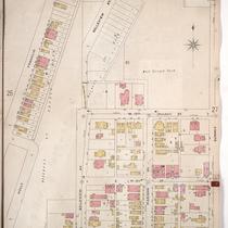
Title
-
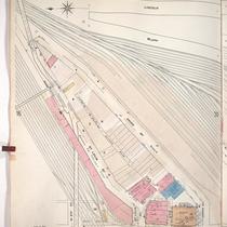
Sanborn Map, Kansas City, Vol. 1, 1909-1938, Page p066
-
Description
-
A portion of Kansas City from 23rd Street Trafficway south to W. 24th Street and from Brook east to Fairmount Avenue, showing buildings, railroads, streets, and additions. Large numbers at edges of page refer to page with adjoining area.
-
Date
-
1909/1938
-
Object Type
-
Map
-
-
Title
-
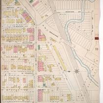
Sanborn Map, Kansas City, Vol. 1, 1909-1938, Page p029
-
Description
-
A portion of Kansas City from Lincoln Street south to Santa Fe and from W. 9th Street east to Union Avenue, showing buildings, streets, and additions. Large numbers at edges of page refer to page with adjoining area.
-
Date
-
1909/1938
-
Object Type
-
Map
-

-
Title
-
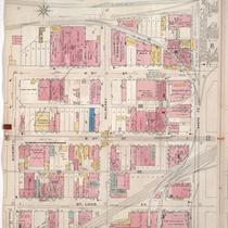
Sanborn Map, Kansas City, Vol. 1, 1909-1938, Page p040
-
Description
-
A portion of Kansas City from W. 12th Street south to W. 13th Street and from Franklin east to Summit Avenue, showing buildings, streets, railroads, and additions. Large numbers at edges of page refer to page with adjoining area.
-
Date
-
1909/1938
-
Object Type
-
Map
-

-
Title
-
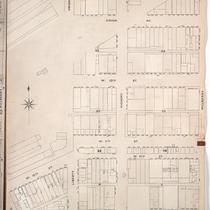
Sanborn Map, Kansas City, Vol. 1A, 1939-1949, Page p189
-
Description
-
A portion of Kansas City from Woodswether Road south to W. 7th Street and from Madison Avenue east to Broadway, showing buildings, railroads and streets. Large numbers at edges of page refer to page with adjoining area
-
Date
-
1939/1949
-
Object Type
-
Map
-

-
Title
-
Sanborn Map, Kansas City, Vol. 1, 1895-1907, Page p023
-
Description
-
Northwestern part of early Kansas City in the West Bottoms from the state line east to Wyoming Street showing buildings, streets, and the Kansas City Stockyards. Large numbers at edges of page refer to page with adjoining area.
-
Date
-
1895/1907
-
Object Type
-
Map
-

-
Title
-
Sanborn Map, Kansas City, Vol. 1, 1895-1907, Page p035
-
Description
-
Northwestern part of early Kansas City in West Bottoms from about W. 15th Street south to W. 17th Street and from the state line east to Wyoming Street. Large numbers at edges of page refer to page with adjoining area.
-
Date
-
1895/1907
-
Object Type
-
Map
-

-
Title
-
Sanborn Map, Kansas City, Vol. 1, 1895-1907, Page p024
-
Description
-
Northwestern part of early Kansas City in West Bottoms from Wyoming Street east to Hickory Street and from W. 13th Street south to W. 15th Street. Large numbers at edges of page refer to page with adjoining area.
-
Date
-
1895/1907
-
Object Type
-
Map
-

-
Title
-
Sanborn Map, Kansas City, Vol. 1, 1895-1907, Page p013
-
Description
-
Northern part of early Kansas City in the West Bottoms from W. 8th Street south to Union Avenue and from Santa Fe Street east to Lincoln Street. Large numbers on the edges of page refer to page with adjoining area.
-
Date
-
1895/1907
-
Object Type
-
Map
-

-
Title
-
Sanborn Map, Kansas City, Vol. 1, 1895-1907, Page p039
-
Description
-
North central part of early Kansas City in West Bottoms showing railroad lines, streets, and buildings. Large numbers at edges of page refer to page with adjoining area.
-
Date
-
1895/1907
-
Object Type
-
Map
-

-
Title
-
Sanborn Map, Kansas City, Vol. 1, 1895-1907, Page p025
-
Description
-
Northern part of early Kansas City in West Bottoms from Mulberry Street east to Holly Street showing railroad lines and buildings. Large numbers at edge of page refer to page with adjoining area.
-
Date
-
1895/1907
-
Object Type
-
Map
-

-
Title
-
Sanborn Map, Kansas City, Vol. 1, 1895-1907, Page p033
-
Description
-
Northwestern part of early Kansas City from W. 15th Street south to W. 17th Street and from Franklin Street east to W. Prospect Place, showing buildings, streets, and railroad lines. Large numbers at edges of page refer to page with adjoining area.
-
Date
-
1895/1907
-
Object Type
-
Map
-
-
Title
-
Sanborn Map, Kansas City, Vol. 1, 1895-1907, Page p054
-
Description
-
North central part of early Kansas City in the West Bottoms area from about W. 24th Street south to W. 25th Street and from Holly Street east to Madison Avenue, showing buildings, streets, and O. K. Creek. Large numbers at edges of page refer to page with adjoining area.
-
Date
-
1895/1907
-
Object Type
-
Map
-

-
Title
-
Sanborn Map, Kansas City, Vol. 1, 1895-1907, Page p020
-
Description
-
Northwestern part of early Kansas City in West Bottoms from Union Avenue south to W. 12th Street and from Mulberry Street east to Santa Fe Street, showing buildings, streets, and railroad lines. Large numbers at edges of page refer to page with adjoining area.
-
Date
-
1895/1907
-
Object Type
-
Map
-
-
Title
-
Sanborn Map, Kansas City, Vol. 1, 1895-1907, Page p014
-
Description
-
Northwestern part of early Kansas City in the West Bottoms district from W. 8th Street south to St. Louis Avenue and from Hickory Street east to Santa Fe Street showing buildings, streets, and railroad lines. Large numbers at edges of page refer to page showing adjoining area.
-
Date
-
1895/1907
-
Object Type
-
Map
-
-
Title
-
Sanborn Map, Kansas City, Vol. 1, 1895-1907, Page p019s
-
Description
-
Skeleton map of northwestern part of early Kansas City in West Bottoms from Union Avenue south to W. 13th Street and from Wyoming Street east to Mulberry Street showing outlines of buildings at the time of publication. These sheets were used to record new developments in the area.
-
Date
-
1895/1907
-
Object Type
-
Map
-

-
Title
-
Sanborn Map, Kansas City, Vol. 1, 1895-1907, Page p040
-
Description
-
North central part of early Kansas City in the West Bottoms from about W. 19th Street south to Cliff Street and from Allen Avenue east to Holly Street, showing buildings, streets, railroad lines, and shops. Large numbers at edges of page refer to page with adjoining area.
-
Date
-
1895/1907
-
Object Type
-
Map
-

-
Title
-
Sanborn Map, Kansas City, Vol. 1, 1895-1907, Page p014s
-
Description
-
Skeleton map of north western part of early Kansas City in the West Bottoms district from W. 8th Street south to St. Louis Avenue and from Hickory Street east to Santa Fe Street showing buildings, street,s and railroad lines. These sheets were used to record new developments in the area.
-
Date
-
1895/1907
-
Object Type
-
Map
-

-
Title
-
Sanborn Map, Kansas City, Vol. 1, 1895-1907, Page p020s
-
Description
-
Skeleton map of northwestern part of early Kansas City in West Bottoms from Union Avenue south to W. 12th Street and from Mulberry Street east to Santa Fe Street showing the outlines of buildings at the time of publication. These sheets were used to record new developments in the area.
-
Date
-
1895/1907
-
Object Type
-
Map
-

-
Title
-
Sanborn Map, Kansas City, Vol. 1, 1895-1907, Page p056
-
Description
-
North central part of early Kansas City in the West Bottoms area from W. 23rd Street south to W. 25th Street and from Fairmount Avenue east to Holly Street, showing buildings, streets, and additions. Large numbers at edges of page refer to page with adjoining area.
-
Date
-
1895/1907
-
Object Type
-
Map
-
-
Title
-
Sanborn Map, Kansas City, Vol. 1, 1895-1907, Page p026
-
Description
-
Northern part of early Kansas City in the West Side neighborhood on the outskirts of the West Bottoms, from Franklin Street east to Summit Street and from W. 12th Street south to W. 14th Street showing streets and residential buildings. Large numbers at edges of page refer to page with adjoining area.
-
Date
-
1895/1907
-
Object Type
-
Map
Pages
