Pages
-

-
Title
-
Sanborn Map, Kansas City, Vol. 4, 1909-1950, Page p539
-
Description
-
A portion of Kansas City from E. 42nd Street south to E. 43rd Street and from Kenwood Avenue east to Harrison Street, showing buildings, streets, and additions. Large numbers at edges of page refer to page with adjoining area.
-
Date
-
1909/1950
-
Object Type
-
Map
-
-
Title
-
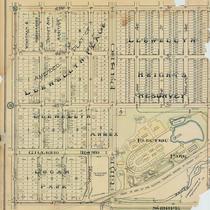
Tuttle & Pike's Atlas of Kansas City and Vicinity
-
Description
-
Single leaf of a cadastral map from a Tuttle & Pike atlas showing the area between Troost and Woodland, from 43rd to 47th. Subdivisions noted are Logan Park, L. Lewellyn Annex, L. Lewellyn Heights Resurvey, and Amended Plat of L. Lewellyn Place. Property owners are not identified. Shows considerable detail of Electric Park. Printed in upper right corner: N 1/2 Sec. 28.
-
Date
-
1907
-
Object Type
-
Map
-

-
Title
-
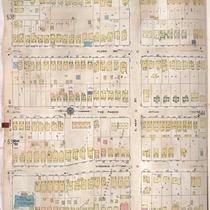
Sanborn Map, Kansas City, Vol. 6, 1917-1945, Page p849
-
Description
-
A portion of Kansas City, Missouri, from about E. 43rd Street south to E. 45th Street and from Bellefontaine east to Indiana Avenue, showing buildings, streets, and additions. Large numbers at edges of page refer to page with adjoining area. At top of map, "New Sheet, Dec. 1931."
-
Date
-
1931
-
Object Type
-
Map
-
-
Title
-
Sanborn Map, Kansas City, Vol. 1, 1895-1907, Page f008
-
Description
-
Key to Sanborn Map of Kansas City, Vol. 1 (corrected to January 1907), showing Kansas City area bounded from the Kansas and Missouri State Line on the west, Cherry on the east, the Missouri River to the north, and East 43rd to the south. Also shows railroads, bridges, parks, and a cemetery. Indicates area covered by volumes 2 and 3.
-
Date
-
1895/1907
-
Object Type
-
Map
-

-
Title
-
Embassy Suites and Westport
-
Description
-
Photograph, looking northwest from the top of the Fountain View (later American Century Investments north tower), toward Westport circa 1987. The Embassy Suites hotel, at at 220 West 43rd Street, occupies the center of the image, with commercial buildings in Westport occupying the background of the image. J. C. Nichols Parkway curves through the upper right, and a building on the St. Luke's Hospital campus occupies the lower left.
-
Date
-
1987~
-
Object Type
-
Photograph
-

-
Title
-
Sanborn Map, Kansas City, Vol. 4, 1909-1957, Page p520
-
Description
-
A portion of Kansas City from W. 42nd Street south to W. 43rd Street and from Roanoke Road east to Pennsylvania Avenue, showing buildings, streets, and additions. Large numbers at edges of page refer to page with adjoining area.
-
Date
-
1909/1957
-
Object Type
-
Map
-

-
Title
-
4212 Washington Street
-
Description
-
Photograph of a house at 4212 Washington Street in the early 1980s. This residence and the St. James Missionary Baptist Church, at the corner of 43rd and Washington, are the only pre-1940 structures remaining on the block, which was part of the historic Steptoe neighborhood, a pre-Civil War African-American neighborhood in the Westport area. The remaining land was reused for a new fire station and a large parking lot.
-
Date
-
1980~/1989~
-
Object Type
-
Photograph
-
-
Title
-
Sanborn Map, Kansas City, Vol. 6, 1917-1945, Page p758
-
Description
-
A portion of northeastern Kansas City from E. 33rd Street to around E. 35th Street and from Bales Avenue east to Monroe Avenue, showing buildings, streets, and additions. A portion from Indiana Avenue east to Askew Avenue on E. 43rd Street is also shown. Large numbers at edges of page refer to page with adjoining area.
-
Date
-
1917/1945
-
Object Type
-
Map
-
-
Title
-
Saint Luke's Hospital
-
Description
-
Photograph looking northwest from the top of the Fountain View building (later American Century north tower) of the St. Luke's Hospital campus, southwest of the intersection of 43rd Street and J. C. Nichols Parkway, circa 1987. The Westport area is visible in the background of the image, and Mill Creek Park at the lower right corner.
-
Date
-
1987~
-
Object Type
-
Photograph
-

-
Title
-
H&R Block Parking Lot
-
Description
-
Photograph of a parking lot at the rear of the H&R Block headquarters, at 4410 Main Street, circa 1980. A portion of a St. Luke's Hospital building can be seen at background left, and the Embassy Suites at 43rd and J. C. Nichols Parkway is visible at background right.
-
Date
-
1980~
-
Object Type
-
Photograph
-

-
Title
-
Plaza Area Plan Transportation Improvements
-
Description
-
Map created by the Kansas City Landmarks Commission as part of a 1980s Plaza Plan presentation, encompassing an area from State Line Road east to The Paseo, and from Westport Road and 39th Street south to 55th Street. The map illustrates proposed transportation improvements along Volker Boulevard, Brookside Boulevard, 47th Street, and 43rd Street. Area plans, dealing with transportation, development, and zoning, among other factors, were developed over time for a number of Kansas City areas and are intended to provide guidance for their growth and design.
-
Date
-
1980~/1989~
-
Object Type
-
Map
-
-
Title
-
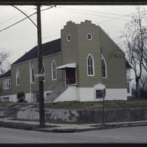
St. Luke's A.M.E. Church
-
Description
-
Photograph of the Saint Luke's A.M.E. Church, in a triangle created by the intersections of the corner of 43rd Street, Archibald Avenue and Roanoke Streets in the early 1980s. The church, established for freed slaves in Kansas City's Steptoe neighborhood after the Civil War, constructed the church building in 1882 and the parsonage at the rear of the property in 1891. A sign reports times for morning worship and church school, and records Dr. Howard S. Gloyd as pastor. The buildings were razed in July 2003 due to deterioration and the widening of 43rd Street. Prior to that, the church was the oldest church in Westport.
-
Date
-
1980~/1989~
-
Object Type
-
Photograph
-
-
Title
-
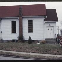
St. James Baptist Church
-
Description
-
Photograph of St. James Baptist Church at 43rd and Washington Streets in the early 1980s. The church and the house at the right edge of the image are, as of 2018, the only pre-1940 structures remaining on the block, which was part of the historic Steptoe neighborhood, a pre-Civil War African-American neighborhood in the Westport area. The remaining land was reused for the new Kansas City Fire Department Station 19 and a large parking lot.
-
Date
-
1980~/1989~
-
Object Type
-
Photograph
-

-
Title
-
Afton Apartments
-
Description
-
Photograph of the Afton Apartment building at 112-22 East 43rd Street in the early 1980s. The colonnade-style building was built circa 1907, and a house at its rear was eventually demolished to build a parking lot for the building. A strip of commercial storefronts built circa 1927, occupied by Bremson Photo Industries at the time of the photo, can be seen at the background of the photo to the west of the Afton.
-
Date
-
1980~/1989~
-
Object Type
-
Photograph
-

-
Title
-
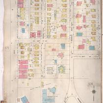
Sanborn Map, Kansas City, Vol. 4, 1909-1957, Page p563
-
Description
-
A portion of Kansas City from W. 43rd Street south to Corbin Terrace and from Madison Avenue east to Pennsylvania Avenue, showing buildings, streets, and additions. Large numbers at edges of page refer to page with adjoining area.
-
Date
-
1909/1957
-
Object Type
-
Map
-

-
Title
-
Sanborn Map, Kansas City, Vol. 4, 1909-1957, Page p530
-
Description
-
A portion of Kansas City from E. 41st Street south to E. 43rd Street and from Main Street east to Oak Street, showing buildings, streets, and additions. Large numbers at edges of page refer to page with adjoining area.
-
Date
-
1909/1957
-
Object Type
-
Map
-
-
Title
-
Sanborn Map, Kansas City, Vol. 4, 1909-1957, Page p543
-
Description
-
A portion of Kansas City from E. 42nd Street south to E. 43rd Street and from Tracy Avenue east to Wayne Avenue, showing buildings, streets, and additions. Large numbers at edges of page refer to page with adjoining area.
-
Date
-
1909/1957
-
Object Type
-
Map
-
-
Title
-
Sanborn Map, Kansas City, Vol. 4, 1909-1957, Page p565
-
Description
-
A portion of Kansas City from E. 43rd Street south to E. 45th Street and from Main Street east to McGee, showing buildings, streets, and additions. Large numbers at edges of page refer to page with adjoining area.
-
Date
-
1909/1957
-
Object Type
-
Map
-

-
Title
-
Sanborn Map, Kansas City, Vol. 4, 1909-1957, Page p518
-
Description
-
A portion of Kansas City from W. 42nd Street south to W. 43rd Street and from Holly Street east to Southwest Trafficway, showing buildings, streets, and additions. Large numbers at edges of page refer to page with adjoining area.
-
Date
-
1909/1957
-
Object Type
-
Map
-

-
Title
-
Sanborn Map, Kansas City, Vol. 4, 1909-1957, Page p571
-
Description
-
A portion of Kansas City from E. 42nd Street south to E. 43rd Street and from Wayne Avenue east to Michigan Avenue, showing buildings, streets, and additions. Large numbers at edges of page refer to page with adjoining area. At top of page, "Add'l Sheet, Oct. 1916."
-
Date
-
1909/1957
-
Object Type
-
Map
Pages
