Pages
-

-
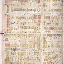
Title
-
Sanborn Map, Kansas City, Vol. 4, 1909-1957, Page p541
-
Description
-
A portion of Kansas City from E. 42nd Street south to E. 43rd Street and from Harrison Street east to Tracy Avenue, showing buildings, streets, and additions. Large numbers at edges of page refer to page with adjoining area.
-
Date
-
1909/1957
-
Object Type
-
Map
-
-
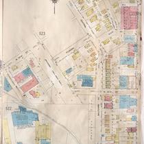
Title
-
Sanborn Map, Kansas City, Vol. 4, 1909-1957, Page p524
-
Description
-
A portion of Kansas City from W. 41st Street south to W. 43rd Street and from Pennsylvania Avenue east to Main Street, showing buildings, streets, and additions. Large numbers at edges of page refer to page with adjoining area.
-
Date
-
1909/1957
-
Object Type
-
Map
-

-
Title
-
Sanborn Map, Kansas City, Vol. 4, 1909-1957, Page p528
-
Description
-
A portion of Kansas City from E. 40th Street south to E. 43rd Street and from Oak Street east to Gillham, showing buildings, streets, and additions. Large numbers at edges of page refer to page with adjoining area.
-
Date
-
1909/1957
-
Object Type
-
Map
-
-
Title
-
Sanborn Map, Kansas City, Vol. 4, 1909-1957, Page p539
-
Description
-
A portion of Kansas City from E. 42nd Street south to E. 43rd Street and from Kenwood Avenue east to Harrison, showing buildings, streets, and additions. Large numbers at edges of page refer to page with adjoining area.
-
Date
-
1909/1957
-
Object Type
-
Map
-

-
Title
-
Sanborn Map, Kansas City, Vol. 4, 1909-1957, Page p556
-
Description
-
A portion of Kansas City from W. 43rd Street south to W. 44th Street Terrace and from Pennsylvania Avenue east to Wornall Road, showing buildings, streets, and additions. Large numbers at edges of page refer to page with adjoining area.
-
Date
-
1909/1957
-
Object Type
-
Map
-
-
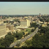
Title
-
St. Luke's Hospital and Westport
-
Description
-
Photograph looking northwest from the top of the Fountain View building (later American Century north tower) along J. C. Nichols Parkway/Broadway Boulevard from roughly 44th Street circa 1987. Buildings on the St. Luke's Hospital campus can be seen at the left edge of the image, and an Embassy Suites Hotel at 220 West 43rd Street at the center of the photo. Buildings in Westport, along Armour Boulevard, and Downtown can be seen in the background of the image. Baltimore Avenue runs north/south at the right edge of the image.
-
Date
-
1987~
-
Object Type
-
Photograph
-
-
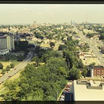
Title
-
J. C. Nichols Parkway and Main Street through Midtown
-
Description
-
Photograph looking northwest from the top of the Fountain View building (later American Century north tower) along J. C. Nichols Parkway/Broadway Boulevard from roughly 44th Street circa 1987. Buildings on the St. Luke's Hospital campus can be seen at the left edge of the image, and an Embassy Suites Hotel at 220 West 43rd Street at the center of the photo. Buildings in Westport, along Armour Boulevard, and Downtown can be seen in the background of the image. Baltimore Avenue runs north/south at the right edge of the image.
-
Date
-
1987~
-
Object Type
-
Photograph
-

-
Title
-
Brush Creek Project Pedestrians Open Space Connections in the Northeast Quadrant
-
Description
-
Map created by the Kansas City Landmarks Commission as part of a 1980s Brush Creek redesign presentation. The map illustrates parks and street connections between 43rd and 50th Streets on the north and south, and Broadway Boulevard and The Paseo on the west and east. Through the 1980s and early 1990s, the city undertook a major redesign of Brush Creek and adjacent areas aimed at beautification and improved flood control.
-
Date
-
1980~/1989~
-
Object Type
-
Map
-

-
Title
-
Plaza Area Plan Area with Specific Guidelines
-
Description
-
Map created by the Kansas City Landmarks Commission as part of a 1980s Plaza Plan presentation, encompassing an area from State Line Road east to The Paseo, and from Westport Road & 39th Street south to 55th Street. The map illustrates an area with specific planning guidelines from 43rd south to Brush Creek Boulevard, and from Main Street east to Warwick Boulevard, and is a detail view of the larger Planning Recommendations map. Area plans, dealing with transportation, development, and zoning, among other factors, were developed over time for a number of Kansas City areas and are intended to provide guidance for their growth and design.
-
Date
-
1980~/1989~
-
Object Type
-
Map
-

-
Title
-
Plaza Area Plan Existing and Proposed Developments
-
Description
-
Map created by the Kansas City Landmarks Commission as part of a 1980s Plaza Plan presentation, encompassing an area from roughly 43rd Street south to 48th Street, and Wornall East to Oak Street. The map illustrates existing buildings, including Fountain View, One Main Plaza, and the Hilton Plaza Hotel; it also includes proposed projects such as Fountain View Two, a realignment of Main Street and Brookside Boulevard, and Brush Creek improvements. Area plans, dealing with transportation, development, and zoning, among other factors, were developed over time for a number of Kansas City areas and are intended to provide guidance for their growth and design.
-
Date
-
1980~/1989~
-
Object Type
-
Map
-

-
Title
-
Plaza Area Plan Area with Specific Guidelines
-
Description
-
Map created by the Kansas City Landmarks Commission as part of a 1980s Plaza Plan presentation, encompassing an area from State Line Road east to The Paseo, and from Westport Road & 39th Street south to 55th Street. The map illustrates an area with specific planning guidelines from 43rd Street south to 46th Street, and along Belleview and Madison Avenues, and is a detail view of the larger Planning Recommendations map. Area plans, dealing with transportation, development, and zoning, among other factors, were developed over time for a number of Kansas City areas and are intended to provide guidance for their growth and design.
-
Date
-
1980~/1989~
-
Object Type
-
Map
-

-
Title
-
Brush Creek Project Residential Actions
-
Description
-
Map created by the Kansas City Landmarks Commission as part of a 1980s Brush Creek redesign presentation, encompassing an area from State Line Road east to The Paseo, and from 43rd Street south to 55th Street. The map denotes smaller areas with numbers 1-4, but does not include a key. Through the 1980s and early 1990s, the city undertook a major redesign of Brush Creek and adjacent areas aimed at beautification and improved flood control.
-
Date
-
1980~/1989~
-
Object Type
-
Map
-
-
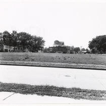
Title
-
Westport Intersection
-
Description
-
View of the intersection of Southwest Trafficway, Madison Avenue, Westport Road, 43rd Street and Belleview Avenue in Westport facing southwest. A building housing Frank's Brake & Clutch Service on the south side of 43rd Street is in view. Billboards for the First National Bank and Holsum Bread can be seen. The First National Bank billboard shows their main location at 10th Street and Baltimore Avenue where the Central Library is located.
-
Object Type
-
Photograph
-

-
Title
-
Sanborn Map, Kansas City, Vol. 6, 1917-1957, Page p777
-
Description
-
A portion of northeastern Kansas City from E. 42nd Street south to about E. 44th Street and from Chestnut Avenue east to Bellefontaine Avenue, showing buildings, streets, and additions. Large numbers at edges of page refer to page with adjoining area.
-
Date
-
1917/1957
-
Object Type
-
Map
-

-
Title
-
Sanborn Map, Kansas City, Vol. 6, 1917-1945, Page p777
-
Description
-
A portion of northeastern Kansas City from E. 42nd Street south to about E. 44th Street and from Chestnut Avenue east to Bellefontaine Avenue, showing buildings, streets, and additions. Large numbers at edges of page refer to page with adjoining area.
-
Date
-
1917/1945
-
Object Type
-
Map
-

-
Title
-
Sanborn Map, Kansas City, Vol. 4, 1909-1950, Page p557
-
Description
-
A portion of Kansas City from Westport Road south to W. 44th Street and from State Line east to Fairmount Avenue, showing buildings, streets, and additions. Large numbers at edges of page refer to page with adjoining area.
-
Date
-
1909/1950
-
Object Type
-
Map
-
-
Title
-
Sanborn Map, Kansas City, Vol. 6, 1917-1957, Page p751
-
Description
-
A portion of Kansas City from E. 42nd Street south to E. 45th Street and from Indiana Avenue east to Myrtle Avenue, showing buildings, streets, and additions. Large numbers at edges of page refer to page with adjoining area. Update at top of page reads "(758) 'NA' May 1945."
-
Date
-
1917/1957
-
Object Type
-
Map
-

-
Title
-
Sanborn Map, Kansas City, Vol. 6, 1917-1957, Page p771
-
Description
-
A portion of northeastern Kansas City from E. 42nd Street south to about E. 44th Street and from Michigan Avenue east to Brooklyn Avenue, showing buildings, streets, and additions. Large numbers at edges of page refer to page with adjoining area.
-
Date
-
1917/1957
-
Object Type
-
Map
-
-
Title
-
Sanborn Map, Kansas City, Vol. 6, 1917-1957, Page p773
-
Description
-
A portion of northeastern Kansas City from E. 42nd Street south to about E. 44th Street and from Brooklyn Avenue east to Wabash Avenue, showing buildings, streets, and additions. Large numbers at edges of page refer to page with adjoining area.
-
Date
-
1917/1957
-
Object Type
-
Map
-

-
Title
-
Sanborn Map, Kansas City, Vol. 6, 1917-1957, Page p752
-
Description
-
A portion of Kansas City from E. 42nd Street south to E. 45th Street and from Myrtle Avenue east to Elmwood, showing buildings, streets, and additions. Large numbers at edges of page refer to page with adjoining area. Update at top of page reads "'NA' June 1941."
-
Date
-
1917/1957
-
Object Type
-
Map
Pages
