-
-
Title
-
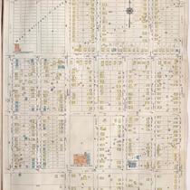
Sanborn Map, Kansas City, Vol. 6, 1917-1957, Page p752
-
Description
-
A portion of Kansas City from E. 42nd Street south to E. 45th Street and from Myrtle Avenue east to Elmwood, showing buildings, streets, and additions. Large numbers at edges of page refer to page with adjoining area. Update at top of page reads "'NA' June 1941."
-
Date
-
1917/1957
-
Object Type
-
Map
-

-
Title
-
Sanborn Map, Kansas City, Vol. 6, 1917-1945, Page p752
-
Description
-
A portion of northeastern Kansas City, Missouri, from E. 42nd Street south to E. 45th Street and from Myrtle Avenue east to Elmwood Avenue, showing buildings, streets, and additions. Large numbers at edges of page refer to page with adjoining area.
-
Date
-
1917/1945
-
Object Type
-
Map
