-
-
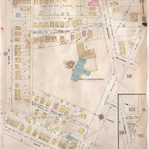
Title
-
Sanborn Map, Kansas City, Vol. 4, 1909-1950, Page p518
-
Description
-
A portion of Kansas City from W. 42nd Street south to W. 43rd Street and from Holly Street east to Roanoke Road, showing buildings, streets, and additions. Large numbers at edges of page refer to page with adjoining area.
-
Date
-
1909/1950
-
Object Type
-
Map
-
-
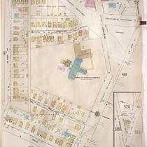
Title
-
Sanborn Map, Kansas City, Vol. 4, 1909-1957, Page p518
-
Description
-
A portion of Kansas City from W. 42nd Street south to W. 43rd Street and from Holly Street east to Southwest Trafficway, showing buildings, streets, and additions. Large numbers at edges of page refer to page with adjoining area.
-
Date
-
1909/1957
-
Object Type
-
Map
-

-
Title
-
Sanborn Map, Kansas City, Vol. 1, 1895-1907, Page p095
-
Description
-
Southern part of early Kansas City on the outskirts of Westport from High Street south to Archibald and from past Greenwood Place east to Belleview, showing buildings, streets, and additions. Large numbers at edges of page refer to page with adjoining area.
-
Date
-
1895/1907
-
Object Type
-
Map
