Pages
-

-
Title
-
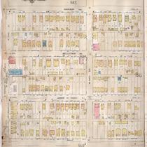
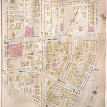
Sanborn Map, Kansas City, Vol. 6, 1917-1945, Page p830
-
Description
-
A portion of Kansas City from E. 42nd Street south to E. 43rd Street and from Bellefontaine Avenue east to Indiana Avenue, showing buildings, streets, and additions. Large numbers at edges of page refer to page with adjoining area.
-
Date
-
1917/1945
-
Object Type
-
Map
-
-
Title
-
Sanborn Map, Kansas City, Vol. 6, 1917-1957, Page p830
-
Description
-
A portion of Kansas City from E. 42nd Street south to E. 43rd Street and from Bellefontaine Avenue east to Indiana Avenue, showing buildings, streets, and additions. Large numbers at edges of page refer to page with adjoining area. Noted at top of page, "New Sheet Dec. 1931."
-
Date
-
1917/1957
-
Object Type
-
Map
-
-
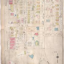
Title
-
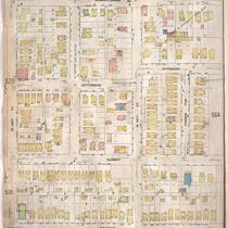
Sanborn Map, Kansas City, Vol. 4, 1909-1950, Page p524
-
Description
-
A portion of Kansas City from W. 42nd Street south to W. 43rd Street and from Pennsylvania Avenue east to Main Street, showing buildings, streets, and additions. Large numbers at edges of page refer to page with adjoining area.
-
Date
-
1909/1950
-
Object Type
-
Map
-
-
Title
-
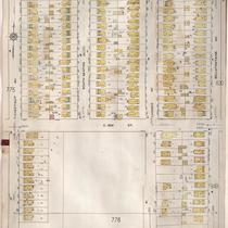
Sanborn Map, Kansas City, Vol. 4, 1909-1950, Page p556
-
Description
-
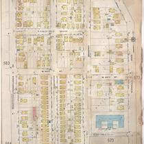
A portion of Kansas City from W. 43rd Street south to W. 44th Street Terrace and from Pennsyvlania Avenue east to Wornall Road, showing buildings, streets, and additions. Large numbers at edges of page refer to page with adjoining area.
-
Date
-
1909/1950
-
Object Type
-
Map
-
-
Title
-
Sanborn Map, Kansas City, Vol. 4, 1909-1950, Page p528
-
Description
-
A portion of Kansas City from E. 40th Street south to E. 43rd Street and from Oak Street east to Gillham Road, showing buildings, streets, and additions. Large numbers at edges of page refer to page with adjoining area.
-
Date
-
1909/1950
-
Object Type
-
Map
-

-
Title
-
Sanborn Map, Kansas City, Vol. 4, 1909-1950, Page p541
-
Description
-
A portion of Kansas City from E. 42nd Street south to E. 43rd Street and from Harrison Street east to Tracy Avenue, showing buildings, streets, and additions. Large numbers at edges of page refer to page with adjoining area.
-
Date
-
1909/1950
-
Object Type
-
Map
-
-
Title
-
Sanborn Map, Kansas City, Vol. 4, 1909-1950, Page p561
-
Description
-
A portion of Kansas City from W. 43rd Street south to W. 44th Street and from Holly Street east to Madison Avenue, showing buildings, streets, and additions. Large numbers at edges of page refer to page with adjoining area.
-
Date
-
1909/1950
-
Object Type
-
Map
-
-
Title
-
Sanborn Map, Kansas City, Vol. 4, 1909-1950, Page p571
-
Description
-
A portion of Kansas City from E. 42nd Street south to E. 43rd Street and from Wayne Avenue east to Michigan Avenue, showing buildings, streets, and additions. Large numbers at edges of page refer to page with adjoining area. At top of map, "Add'l Sheet, Oct. 1916."
-
Date
-
1909/1950
-
Object Type
-
Map
-
-
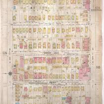
Title
-
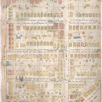
Sanborn Map, Kansas City, Vol. 4, 1909-1950, Page p530
-
Description
-
A portion of Kansas City from E. 41st Street south to E. 43rd Street and from Main Street east to Oak Street, showing buildings, streets, and additions. Large numbers at edges of page refer to page with adjoining area.
-
Date
-
1909/1950
-
Object Type
-
Map
-

-
Title
-
Sanborn Map, Kansas City, Vol. 4, 1909-1950, Page p522
-
Description
-
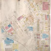
A portion of Kansas City from Westport Road south to W. 43rd Street and from Pennsylvania Avenue east to Wornall Road, showing buildings, streets, and additions. Large numbers at edges of page refer to page with adjoining area.
-
Date
-
1909/1950
-
Object Type
-
Map
-
-
Title
-
Sanborn Map, Kansas City, Vol. 4, 1909-1950, Page p565
-
Description
-
A portion of Kansas City from E. 43rd Street south to E. 45th Street and from Main Street east to McGee, showing buildings, streets, and additions. Large numbers at edges of page refer to page with adjoining area.
-
Date
-
1909/1950
-
Object Type
-
Map
-
-
Title
-
Sanborn Map, Kansas City, Vol. 4, 1909-1950, Page p520
-
Description
-
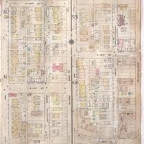
A portion of Kansas City from W. 42nd Street south to W. 43rd Street and from Roanoke Road east to Pennsylvania Avenue, showing buildings, streets, and additions. Large numbers at edges of page refer to page with adjoining area.
-
Date
-
1909/1950
-
Object Type
-
Map
-
-
Title
-
Sanborn Map, Kansas City, Vol. 4, 1909-1950, Page p563
-
Description
-
A portion of Kansas City from W. 43rd Street south to Corbin Terrace and from Madison Avenue east to Pennsylvania Avenue, showing buildings, streets, and additions. Large numbers at edges of page refer to page with adjoining area.
-
Date
-
1909/1950
-
Object Type
-
Map
-

-
Title
-
Sanborn Map, Kansas City, Vol. 4, 1909-1950, Page p518
-
Description
-
A portion of Kansas City from W. 42nd Street south to W. 43rd Street and from Holly Street east to Roanoke Road, showing buildings, streets, and additions. Large numbers at edges of page refer to page with adjoining area.
-
Date
-
1909/1950
-
Object Type
-
Map
-

-
Title
-
Sanborn Map, Kansas City, Vol. 4, 1909-1950, Page p543
-
Description
-
A portion of Kansas City from E. 42nd Street south to E. 43rd Street and from Tracy Avenue east to Wayne Avenue, showing buildings, streets, and additions. Large numbers at edges of page refer to page with adjoining area.
-
Date
-
1909/1950
-
Object Type
-
Map
-
-
Title
-
Sanborn Map, Kansas City, Vol. 4, 1909-1950, Page p539
-
Description
-
A portion of Kansas City from E. 42nd Street south to E. 43rd Street and from Kenwood Avenue east to Harrison Street, showing buildings, streets, and additions. Large numbers at edges of page refer to page with adjoining area.
-
Date
-
1909/1950
-
Object Type
-
Map
-

-
Title
-
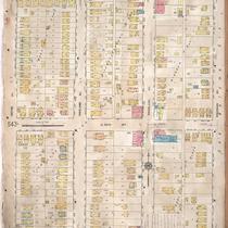
Sanborn Map, Kansas City, Vol. 6, 1917-1945, Page p758
-
Description
-
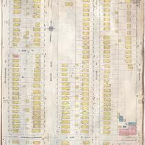
A portion of northeastern Kansas City from E. 33rd Street to around E. 35th Street and from Bales Avenue east to Monroe Avenue, showing buildings, streets, and additions. A portion from Indiana Avenue east to Askew Avenue on E. 43rd Street is also shown. Large numbers at edges of page refer to page with adjoining area.
-
Date
-
1917/1945
-
Object Type
-
Map
-
-
Title
-
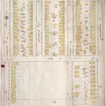
Sanborn Map, Kansas City, Vol. 6, 1917-1957, Page p777
-
Description
-
A portion of northeastern Kansas City from E. 42nd Street south to about E. 44th Street and from Chestnut Avenue east to Bellefontaine Avenue, showing buildings, streets, and additions. Large numbers at edges of page refer to page with adjoining area.
-
Date
-
1917/1957
-
Object Type
-
Map
-
-
Title
-
Sanborn Map, Kansas City, Vol. 6, 1917-1945, Page p777
-
Description
-
A portion of northeastern Kansas City from E. 42nd Street south to about E. 44th Street and from Chestnut Avenue east to Bellefontaine Avenue, showing buildings, streets, and additions. Large numbers at edges of page refer to page with adjoining area.
-
Date
-
1917/1945
-
Object Type
-
Map
-

-
Title
-
Sanborn Map, Kansas City, Vol. 4, 1909-1950, Page p557
-
Description
-
A portion of Kansas City from Westport Road south to W. 44th Street and from State Line east to Fairmount Avenue, showing buildings, streets, and additions. Large numbers at edges of page refer to page with adjoining area.
-
Date
-
1909/1950
-
Object Type
-
Map
Pages
