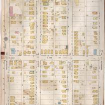
-
-
Title
-
Sanborn Map, Kansas City, Vol. 6, 1917-1957, Page p830
-
Description
-
A portion of Kansas City from E. 42nd Street south to E. 43rd Street and from Bellefontaine Avenue east to Indiana Avenue, showing buildings, streets, and additions. Large numbers at edges of page refer to page with adjoining area. Noted at top of page, "New Sheet Dec. 1931."
-
Date
-
1917/1957
-
Object Type
-
Map
-

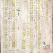
-
Title
-
Sanborn Map, Kansas City, Vol. 6, 1917-1957, Page p777
-
Description
-
A portion of northeastern Kansas City from E. 42nd Street south to about E. 44th Street and from Chestnut Avenue east to Bellefontaine Avenue, showing buildings, streets, and additions. Large numbers at edges of page refer to page with adjoining area.
-
Date
-
1917/1957
-
Object Type
-
Map
-

-
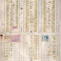
Title
-
Sanborn Map, Kansas City, Vol. 6, 1917-1957, Page p751
-
Description
-
A portion of Kansas City from E. 42nd Street south to E. 45th Street and from Indiana Avenue east to Myrtle Avenue, showing buildings, streets, and additions. Large numbers at edges of page refer to page with adjoining area. Update at top of page reads "(758) 'NA' May 1945."
-
Date
-
1917/1957
-
Object Type
-
Map
-
-
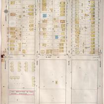
Title
-
Sanborn Map, Kansas City, Vol. 6, 1917-1957, Page p771
-
Description
-
A portion of northeastern Kansas City from E. 42nd Street south to about E. 44th Street and from Michigan Avenue east to Brooklyn Avenue, showing buildings, streets, and additions. Large numbers at edges of page refer to page with adjoining area.
-
Date
-
1917/1957
-
Object Type
-
Map
-
-
Title
-
Sanborn Map, Kansas City, Vol. 6, 1917-1957, Page p773
-
Description
-
A portion of northeastern Kansas City from E. 42nd Street south to about E. 44th Street and from Brooklyn Avenue east to Wabash Avenue, showing buildings, streets, and additions. Large numbers at edges of page refer to page with adjoining area.
-
Date
-
1917/1957
-
Object Type
-
Map
-

-
Title
-
Sanborn Map, Kansas City, Vol. 6, 1917-1957, Page p752
-
Description
-
A portion of Kansas City from E. 42nd Street south to E. 45th Street and from Myrtle Avenue east to Elmwood, showing buildings, streets, and additions. Large numbers at edges of page refer to page with adjoining area. Update at top of page reads "'NA' June 1941."
-
Date
-
1917/1957
-
Object Type
-
Map
-
-
Title
-
Sanborn Map, Kansas City, Vol. 6, 1917-1957, Page p775
-
Description
-
A portion of northeastern Kansas City from E. 42nd Street south to about E. 44th Street and from Wabash Avenue east to Chestnut Avenue, showing buildings, streets, and additions. Large numbers at edges of page refer to page with adjoining area.
-
Date
-
1917/1957
-
Object Type
-
Map
