-

-
Title
-
20 West 43rd Street
-
Description
-
Photograph of a house at 20 West 43rd Street in the early 1980s, covered in ivy and with lit lamps in the window. Numerous houses at its rear along Baltimore Street were demolished to create parking lots for adjacent businesses. The house was later converted to use as office space.
-
Date
-
1980~/1989~
-
Object Type
-
Photograph
-
-
Title
-
20 West 43rd Street
-
Description
-
Photograph of a house at 20 West 43rd Street in the early 1980s, covered in ivy and with lit lamps in the window. Numerous houses at its rear along Baltimore Street were demolished to create parking lots for adjacent businesses. The house was later converted to use as office space.
-
Date
-
1980~/1989~
-
Object Type
-
Photograph
-

-
Title
-
301-21 East 43rd Street
-
Description
-
Photograph of a block of Kansas City sixplex colonnade apartments at 301-21 East 43rd Street, at the corner of 43rd and McGee, circa 1981. These apartments, in a variation on a style common in the city, were built in the early 1920s, and remain standing as of 2018.
-
Date
-
1980~/1989~
-
Object Type
-
Photograph
-

-
Title
-
Saint Luke's Hospital
-
Description
-
Photograph of St. Luke's Hospital, looking southwest from J. C. Nichols Parkway south of 43rd Street, during the 1980s. Mill Creek Park is in the foreground of the image. St. Luke's relocated to the site in 1923, and the building pictured was constructed in the 1960s.
-
Date
-
1980~/1989~
-
Object Type
-
Photograph
-

-
Title
-
Afton Apartments
-
Description
-
Photograph of the Afton Apartment building at 112-22 East 43rd Street in the early 1980s. The colonnade-style building was built circa 1907, and a house at its rear was eventually demolished to build a parking lot for the building.
-
Date
-
1980~/1989~
-
Object Type
-
Photograph
-
-
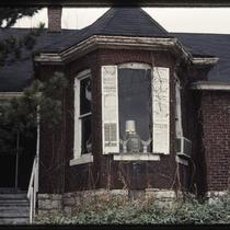
Title
-
St. Luke's A.M.E. Church and Parsonage
-
Description
-
Photograph of the Saint Luke's A.M.E. Church, in a triangle created by the intersections of the corner of 43rd Street, Archibald Avenue and Roanoke Streets in the early 1980s. The church, established for freed slaves in Kansas City's Steptoe neighborhood after the Civil War, constructed the church building in 1882 and the parsonage at the rear of the property in 1891. It was razed in July 2003 due to building deterioration and the widening of 43rd Street. Prior to that, the church was the oldest church in Westport.
-
Date
-
1980~/1989~
-
Object Type
-
Photograph
-
-
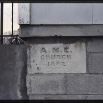
Title
-
St. Luke's A.M.E. Church Cornerstone
-
Description
-
Photograph of the Saint Luke's A.M.E. Church cornerstone, in a triangle created by the intersections of the corner of 43rd Street, Archibald Avenue and Roanoke Streets in the early 1980s. The stone records the date of the church's construction as 1882. The church was established for freed slaves in Kansas City's Steptoe neighborhood after the Civil War, and the parsonage at the rear of the property was added in 1891. The buildings were razed in July 2003 due to deterioration and the widening of 43rd Street. Prior to that, the church was the oldest church in Westport.
-
Date
-
1980~/1989~
-
Object Type
-
Photograph
-

-
Title
-
St. Luke's A.M.E. Church and Parsonage
-
Description
-
Photograph of the Saint Luke's A.M.E. Church, in a triangle created by the intersections of the corner of 43rd Street, Archibald Avenue and Roanoke Streets in the early 1980s. The church, established for freed slaves in Kansas City's Steptoe neighborhood after the Civil War, constructed the church building in 1882 and the parsonage at the rear of the property in 1891. The buildings were razed in July 2003 due to deterioration and the widening of 43rd Street. Prior to that, the church was the oldest church in Westport.
-
Date
-
1980~/1989~
-
Object Type
-
Photograph
-

-
Title
-
4212 Washington Street
-
Description
-
Photograph of a house at 4212 Washington Street in the early 1980s. This residence and the St. James Missionary Baptist Church, at the corner of 43rd and Washington, are the only pre-1940 structures remaining on the block, which was part of the historic Steptoe neighborhood, a pre-Civil War African-American neighborhood in the Westport area. The remaining land was reused for a new fire station and a large parking lot.
-
Date
-
1980~/1989~
-
Object Type
-
Photograph
-
-
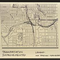
Title
-
Plaza Area Plan Transportation Improvements
-
Description
-
Map created by the Kansas City Landmarks Commission as part of a 1980s Plaza Plan presentation, encompassing an area from State Line Road east to The Paseo, and from Westport Road and 39th Street south to 55th Street. The map illustrates proposed transportation improvements along Volker Boulevard, Brookside Boulevard, 47th Street, and 43rd Street. Area plans, dealing with transportation, development, and zoning, among other factors, were developed over time for a number of Kansas City areas and are intended to provide guidance for their growth and design.
-
Date
-
1980~/1989~
-
Object Type
-
Map
-
-
Title
-
St. Luke's A.M.E. Church
-
Description
-
Photograph of the Saint Luke's A.M.E. Church, in a triangle created by the intersections of the corner of 43rd Street, Archibald Avenue and Roanoke Streets in the early 1980s. The church, established for freed slaves in Kansas City's Steptoe neighborhood after the Civil War, constructed the church building in 1882 and the parsonage at the rear of the property in 1891. A sign reports times for morning worship and church school, and records Dr. Howard S. Gloyd as pastor. The buildings were razed in July 2003 due to deterioration and the widening of 43rd Street. Prior to that, the church was the oldest church in Westport.
-
Date
-
1980~/1989~
-
Object Type
-
Photograph
-

-
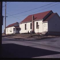
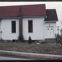
Title
-
St. James Baptist Church
-
Description
-
Photograph of St. James Baptist Church at 43rd and Washington Streets in the early 1980s. The church and the house at the right edge of the image are, as of 2018, the only pre-1940 structures remaining on the block, which was part of the historic Steptoe neighborhood, a pre-Civil War African-American neighborhood in the Westport area. The remaining land was reused for the new Kansas City Fire Department Station 19 and a large parking lot.
-
Date
-
1980~/1989~
-
Object Type
-
Photograph
-
-
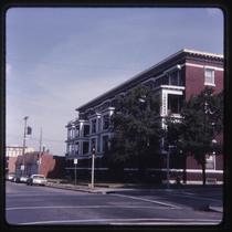
Title
-
Afton Apartments
-
Description
-
Photograph of the Afton Apartment building at 112-22 East 43rd Street in the early 1980s. The colonnade-style building was built circa 1907, and a house at its rear was eventually demolished to build a parking lot for the building. A strip of commercial storefronts built circa 1927, occupied by Bremson Photo Industries at the time of the photo, can be seen at the background of the photo to the west of the Afton.
-
Date
-
1980~/1989~
-
Object Type
-
Photograph
-
-
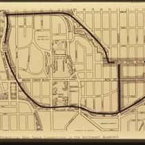
Title
-
Brush Creek Project Pedestrians Open Space Connections in the Northeast Quadrant
-
Description
-
Map created by the Kansas City Landmarks Commission as part of a 1980s Brush Creek redesign presentation. The map illustrates parks and street connections between 43rd and 50th Streets on the north and south, and Broadway Boulevard and The Paseo on the west and east. Through the 1980s and early 1990s, the city undertook a major redesign of Brush Creek and adjacent areas aimed at beautification and improved flood control.
-
Date
-
1980~/1989~
-
Object Type
-
Map
-
-
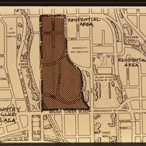
Title
-
Plaza Area Plan Area with Specific Guidelines
-
Description
-
Map created by the Kansas City Landmarks Commission as part of a 1980s Plaza Plan presentation, encompassing an area from State Line Road east to The Paseo, and from Westport Road & 39th Street south to 55th Street. The map illustrates an area with specific planning guidelines from 43rd south to Brush Creek Boulevard, and from Main Street east to Warwick Boulevard, and is a detail view of the larger Planning Recommendations map. Area plans, dealing with transportation, development, and zoning, among other factors, were developed over time for a number of Kansas City areas and are intended to provide guidance for their growth and design.
-
Date
-
1980~/1989~
-
Object Type
-
Map
-
-
Title
-
Plaza Area Plan Existing and Proposed Developments
-
Description
-
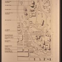
Map created by the Kansas City Landmarks Commission as part of a 1980s Plaza Plan presentation, encompassing an area from roughly 43rd Street south to 48th Street, and Wornall East to Oak Street. The map illustrates existing buildings, including Fountain View, One Main Plaza, and the Hilton Plaza Hotel; it also includes proposed projects such as Fountain View Two, a realignment of Main Street and Brookside Boulevard, and Brush Creek improvements. Area plans, dealing with transportation, development, and zoning, among other factors, were developed over time for a number of Kansas City areas and are intended to provide guidance for their growth and design.
-
Date
-
1980~/1989~
-
Object Type
-
Map
-
-
Title
-
Plaza Area Plan Area with Specific Guidelines
-
Description
-
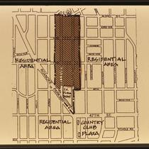
Map created by the Kansas City Landmarks Commission as part of a 1980s Plaza Plan presentation, encompassing an area from State Line Road east to The Paseo, and from Westport Road & 39th Street south to 55th Street. The map illustrates an area with specific planning guidelines from 43rd Street south to 46th Street, and along Belleview and Madison Avenues, and is a detail view of the larger Planning Recommendations map. Area plans, dealing with transportation, development, and zoning, among other factors, were developed over time for a number of Kansas City areas and are intended to provide guidance for their growth and design.
-
Date
-
1980~/1989~
-
Object Type
-
Map
-
-
Title
-
Brush Creek Project Residential Actions
-
Description
-
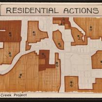
Map created by the Kansas City Landmarks Commission as part of a 1980s Brush Creek redesign presentation, encompassing an area from State Line Road east to The Paseo, and from 43rd Street south to 55th Street. The map denotes smaller areas with numbers 1-4, but does not include a key. Through the 1980s and early 1990s, the city undertook a major redesign of Brush Creek and adjacent areas aimed at beautification and improved flood control.
-
Date
-
1980~/1989~
-
Object Type
-
Map
