Pages
-

-
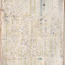
Title
-
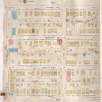
Sanborn Map, Kansas City, Vol. 4, 1909-1957, Page p555
-
Description
-
A portion of Kansas City from W. 41st Street south to Westport Road and from Terrace east to Holly, showing buildings, streets, and additions. Large numbers at edges of page refer to page with adjoining area.
-
Date
-
1909/1957
-
Object Type
-
Map
-

-
Title
-
Sanborn Map, Kansas City, Vol. 4, 1909-1950, Page p574
-
Description
-
A portion of Kansas City from E. 44th Street south to E. 47th Street and from Walnut Street east to Kenwood Avenue, showing buildings, streets, and additions. Large numbers at edges of page refer to page with adjoining area. At top of map, "Add'l Sheet, Oct. 1916."
-
Date
-
1909/1950
-
Object Type
-
Map
-

-
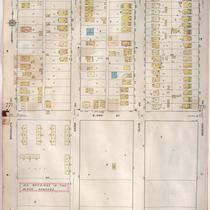
Title
-
Sanborn Map, Kansas City, Vol. 4, 1909-1950, Page p573
-
Description
-
A portion of Kansas City from W. 44th Street south to W. 47th Street and from Pennsyvlania Avenue east to Main Street, showing buildings, streets, and additions. Large numbers at edges of page refer to page with adjoining area. At top of map, "Add'l Sheet, Oct. 1916."
-
Date
-
1909/1950
-
Object Type
-
Map
-

-
Title
-
Valentine Road
-
Description
-
Postcard of Valentine Road
-
Object Type
-
Postcard
-

-
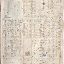
Title
-
Sanborn Map, Kansas City, Vol. 4, 1909-1950, Page p557
-
Description
-
A portion of Kansas City from Westport Road south to W. 44th Street and from State Line east to Fairmount Avenue, showing buildings, streets, and additions. Large numbers at edges of page refer to page with adjoining area.
-
Date
-
1909/1950
-
Object Type
-
Map
-
-
Title
-
Sanborn Map, Kansas City, Vol. 6, 1917-1957, Page p751
-
Description
-
A portion of Kansas City from E. 42nd Street south to E. 45th Street and from Indiana Avenue east to Myrtle Avenue, showing buildings, streets, and additions. Large numbers at edges of page refer to page with adjoining area. Update at top of page reads "(758) 'NA' May 1945."
-
Date
-
1917/1957
-
Object Type
-
Map
-

-
Title
-
Sanborn Map, Kansas City, Vol. 6, 1917-1957, Page p771
-
Description
-
A portion of northeastern Kansas City from E. 42nd Street south to about E. 44th Street and from Michigan Avenue east to Brooklyn Avenue, showing buildings, streets, and additions. Large numbers at edges of page refer to page with adjoining area.
-
Date
-
1917/1957
-
Object Type
-
Map
-
-
Title
-
Sanborn Map, Kansas City, Vol. 6, 1917-1957, Page p773
-
Description
-
A portion of northeastern Kansas City from E. 42nd Street south to about E. 44th Street and from Brooklyn Avenue east to Wabash Avenue, showing buildings, streets, and additions. Large numbers at edges of page refer to page with adjoining area.
-
Date
-
1917/1957
-
Object Type
-
Map
-
-
Title
-
Sanborn Map, Kansas City, Vol. 6, 1917-1957, Page p752
-
Description
-
A portion of Kansas City from E. 42nd Street south to E. 45th Street and from Myrtle Avenue east to Elmwood, showing buildings, streets, and additions. Large numbers at edges of page refer to page with adjoining area. Update at top of page reads "'NA' June 1941."
-
Date
-
1917/1957
-
Object Type
-
Map
-
-
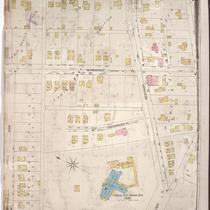
Title
-
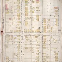
Sanborn Map, Kansas City, Vol. 1, 1895-1907, Page p095
-
Description
-
Southern part of early Kansas City on the outskirts of Westport from High Street south to Archibald and from past Greenwood Place east to Belleview, showing buildings, streets, and additions. Large numbers at edges of page refer to page with adjoining area.
-
Date
-
1895/1907
-
Object Type
-
Map
-

-
Title
-
Sanborn Map, Kansas City, Vol. 4, 1909-1957, Page p554
-
Description
-
A portion of Kansas City from W. 42nd Street south to Westport Road and from State Line east to Terrace, showing buildings, streets, and additions. Large numbers at edges of page refer to page with adjoining area.
-
Date
-
1909/1957
-
Object Type
-
Map
-

-
Title
-
Sanborn Map, Kansas City, Vol. 4, 1909-1957, Page p557
-
Description
-
A portion of Kansas City from Westport Road south to W. 44th Street and from State Line east to Fairmount, showing buildings, streets, and additions. Large numbers at edges of page refer to page with adjoining area.
-
Date
-
1909/1957
-
Object Type
-
Map
-
-
Title
-
Sanborn Map, Kansas City, Vol. 4, 1909-1957, Page p561
-
Description
-
A portion of Kansas City from Westport Road south to W. 44th Street and from Holly Street east to Madison Avenue, showing buildings, streets, and additions. Large numbers at edges of page refer to page with adjoining area.
-
Date
-
1909/1957
-
Object Type
-
Map
-

-
Title
-
Sanborn Map, Kansas City, Vol. 4, 1909-1957, Page p559
-
Description
-
A portion of Kansas City from Westport Road south to W. 44th Street and from Fairmount Avenue east to Holly Street, showing buildings, streets, and additions. Large numbers at edges of page refer to page with adjoining area.
-
Date
-
1909/1957
-
Object Type
-
Map
-
-
Title
-
Sanborn Map, Kansas City, Vol. 6, 1917-1945, Page p771
-
Description
-
A portion of northeastern Kansas City from E. 42nd Street south to about E. 44th Street and from Michigan Avenue east to Brooklyn Avenue, showing buildings, streets, and additions. Large numbers at edges of page refer to page with adjoining area.
-
Date
-
1917/1945
-
Object Type
-
Map
-

-
Title
-
Sanborn Map, Kansas City, Vol. 6, 1917-1945, Page p775
-
Description
-
A portion of northeastern Kansas City from E. 42nd Street south to about E. 44th Street and from Wabash Avenue east to Chestnut Avenue, showing buildings, streets, and additions. Large numbers at edges of page refer to page with adjoining area.
-
Date
-
1917/1945
-
Object Type
-
Map
-

-
Title
-
Sanborn Map, Kansas City, Vol. 6, 1917-1945, Page p751
-
Description
-
A portion of northeastern Kansas City, Missouri, from E. 42nd Street south to E. 45th Street Terrace and from Indiana Avenue east to Myrtle Avenue, showing buildings, streets, and additions. Large numbers at edges of page refer to page with adjoining area. (This volume begins with page 751.)
-
Date
-
1917/1945
-
Object Type
-
Map
-

-
Title
-
Sanborn Map, Kansas City, Vol. 6, 1917-1945, Page p752
-
Description
-
A portion of northeastern Kansas City, Missouri, from E. 42nd Street south to E. 45th Street and from Myrtle Avenue east to Elmwood Avenue, showing buildings, streets, and additions. Large numbers at edges of page refer to page with adjoining area.
-
Date
-
1917/1945
-
Object Type
-
Map
-

-
Title
-
Sanborn Map, Kansas City, Vol. 6, 1917-1945, Page p773
-
Description
-
A portion of northeastern Kansas City from E. 42nd Street south to about E. 44th Street and from Brooklyn Avenue east to Wabash Avenue, showing buildings, streets, and additions. Large numbers at edges of page refer to page with adjoining area.
-
Date
-
1917/1945
-
Object Type
-
Map
-

-
Title
-
Sanborn Map, Kansas City, Vol. 6, 1917-1957, Page p775
-
Description
-
A portion of northeastern Kansas City from E. 42nd Street south to about E. 44th Street and from Wabash Avenue east to Chestnut Avenue, showing buildings, streets, and additions. Large numbers at edges of page refer to page with adjoining area.
-
Date
-
1917/1957
-
Object Type
-
Map
Pages
